Summary of climate disasters on the planet, September 17–23, 2025
Imagine: you are on board an airplane—and suddenly it plunges downward.
On the same day, passengers on two separate flights across different continents experienced this nightmare — severe turbulence that is fast becoming a real threat to millions of people.
While flight crews battle air pockets in the sky, cataclysms are raging on the ground.
In this episode, we’ll cover the most devastating climate events of the past week, from September 17 to 23, 2025, and explore the most dangerous side of turbulence — and the potential risks it poses to air travel in the near future.
Super Typhoon Ragasa
On September 22, Super Typhoon Ragasa — also known as Nando — swept across the Philippines. Sustained wind speeds exceeded 265 km/h (165 mph), with gusts reaching 295 km/h (183 mph) — equivalent to a Category 5 tropical hurricane.
Along the coasts of the provinces of Batanes, Cagayan, and Ilocos, wave heights reached 14 meters (46 ft). Ragasa became the strongest tropical cyclone on the planet this year.
The typhoon’s center passed over the Babuyan archipelago, dangerously close to the densely populated island of Luzon. Nearly 25,000 people were evacuated in advance and placed in temporary shelters.
The storm damaged power transmission lines, uprooted countless trees, and triggered floods and landslides in several regions.
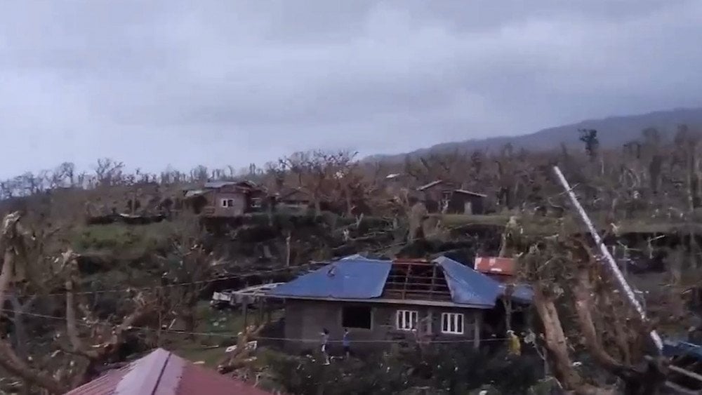
Aftermath of Super Typhoon Ragasa in Cagayan Province, the Philippines
Domestic flights, ferry routes, and fishing operations were suspended.
Schools and government offices in 29 provinces, including the capital, Manila, temporarily halted operations.
Thousands of hectares of rice and corn fields ready for harvest were flooded or destroyed by the winds, threatening the food security of the entire region.
In the northern province of Benguet, one person was killed and seven others injured after a landslide struck a major highway.
A tragedy also occurred at sea: a fishing boat carrying 13 people capsized under massive waves and winds — 7 people died.
The island of Taiwan was also affected by Typhoon Ragasa. Starting on September 22, its outer bands brought unprecedented rainfall to the island’s east — in some areas, around 1,000 mm (39 in) of rain fell.
On September 23, in Hualien County, rains overflowed a lake that had formed earlier this summer as a result of a landslide. As a result, 60 million tons of water broke through a natural dam and rushed down the valley toward the tourist town of Guangfu.
Eyewitnesses said it looked like a tsunami: raging torrents of water mixed with silt and mud swept through entire districts, destroying houses and vehicles.
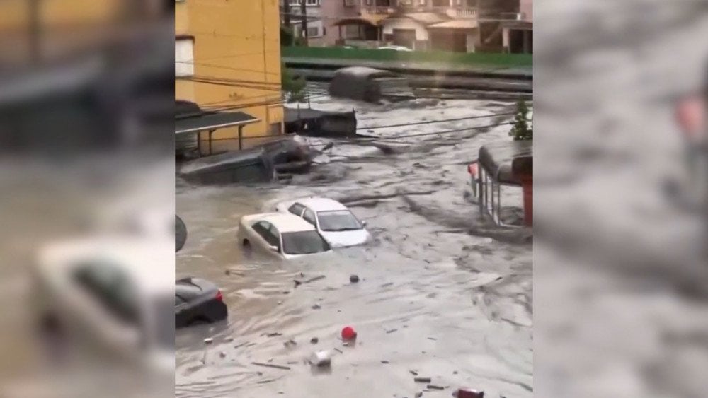
Typhoon Ragasa struck Taiwan: torrential rains turned streets into raging rivers, sweeping away everything in their path
Residents were forced to take refuge on the upper floors of buildings.
Bridges and roads in the county were closed, and train services were suspended.
At least 17 people were confirmed dead, with another 17 missing.
On September 24, the typhoon reached mainland China, affecting residents of Hong Kong, Macau, and the provinces of Guangdong and Guangxi.
In Guangdong Province, more than 2 million people were evacuated as a precaution. In the city of Yangjiang, powerful wind gusts uprooted over 50,000 trees, damaged numerous buildings, and caused mass power outages.
In Hong Kong, the highest danger level was declared, and more than 100 people were injured.

Aftermath of Typhoon Ragasa — tens of thousands of trees uprooted in Yangjiang City, Guangdong Province, China
USA
On September 18, thunderstorms brought by the remnants of Tropical Storm Mario triggered powerful landslides and flash floods in Southern California.
The areas of Oak Glen, Forest Falls, and Potato Canyon in San Bernardino County were severely affected, where in some locations, nearly four months’ worth of rain fell within just one hour.
Rivers of mud flooded roads and homes, and ten people, trapped in their vehicles on the highway, remained stuck for about ten hours before rescuers managed to clear a path.
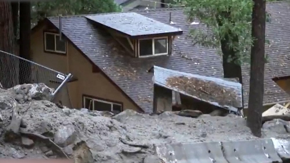
Southern California hit by sudden downpours and landslides, USA
Flooding also reached the desert region. In Death Valley National Park, torrential rains turned roads into muddy rivers, forcing the closure of several routes.
A tragedy occurred near the city of Barstow: torrents of water swept away a car carrying a father and his two-year-old son. Sadly, the child did not survive.
During the storm, over 9,200 lightning strikes were recorded — an anomalously high number for such an arid region.
September in Southern California is usually almost rainless, but this time, the land affected by the 2020 fires received an abnormal amount of precipitation. Scorched soil caused the slopes to lose their ability to retain moisture and triggered devastating mudslides and debris flows.
Georgia
Starting September 20, a storm accompanied by torrential rainfall struck Georgia. The Adjara Republic was hit hardest: roads, residential buildings, and farmlands were flooded, and power transmission lines were damaged.
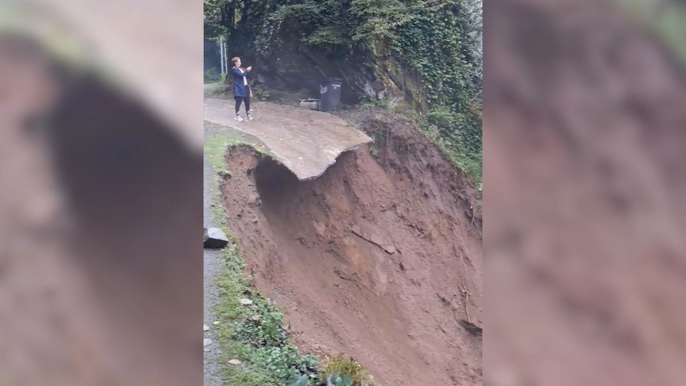
Part of a road collapsed after heavy rain in Adjara, Georgia
The city of Batumi — the capital of the Autonomous Republic of Adjara, one of the country’s largest cities and its main seaside resort — was also severely affected. Strong winds toppled trees in parks and squares, while the heavy rains polluted the main water intake, leaving much of the city without drinking water.
Powerful surf damaged the coastline and beach infrastructure.
Along almost the entire Adjaran coast, waves washed ashore large amounts of algae and debris, forcing authorities to impose a strict ban on swimming in the sea.
In the Khelvachauri municipality, the river overflowed its banks and flooded one of Adjara’s most picturesque areas — the Machakhela Valley — and cut it off from the outside world. Some residents were evacuated to safer locations. The region’s tourist infrastructure suffered serious damage: cafés and restaurants, including a popular venue within the Machakhela National Park, were flooded.
In the Keda municipality, two people were injured when a residential building collapsed.
On September 21, continuous rain caused severe damage to several municipalities in the Samegrelo–Upper Svaneti region, particularly Tsalenjikha, Khobi, and Poti.
Heavy rain flooded streets and residential homes in the Khobi municipality, Samegrelo–Upper Svaneti region, Georgia
Commercial facilities, ground floors of residential buildings, and gardens were flooded. Local residents have had their household appliances and furniture damaged, and their winter supplies destroyed.
The rains also damaged bridge culverts, and some roads became blocked by landslides.
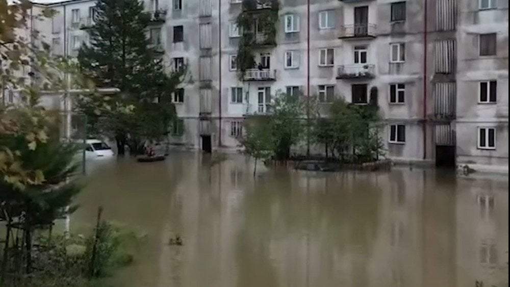
Russia
Starting on September 17, the Republic of Dagestan was struck by extreme downpours, bringing chaos and destruction to people’s daily lives.
In Makhachkala, the capital of the republic, half of the monthly rainfall fell within just three hours. The city’s streets instantly turned into rivers, and cars floated in torrents of water.
In the following days, the situation worsened: in less than two days — September 19–20 — 96.3 mm (3.8 in) of rain fell, an amount that usually accumulates over two months (the average for September is 48 mm (1.9 in)).
The city administration urged residents not to drink tap water, fearing contamination of the water supply system.
Most of the foothill region of Dagestan, including major cities such as Izberbash, Kaspiysk, and Makhachkala, was hit by the severe storm.
Cars stalled right on the streets, and some were carried away by the current. In some areas, the water rose so high that it poured into homes through windows.

Aftermath of extreme rainfall in Makhachkala — muddy floodwaters burst into apartments through windows, Republic of Dagestan, Russia
73 settlements were left without electricity. Internet and mobile communication were disrupted, and some districts experienced a complete blackout.
Because of destroyed bridges and landslides, 40 villages were cut off from transport connections. Bridges over the Ulluchay River, the Shura-Ozen River, and on the Madzhalis–Varsit–Shilansha road were destroyed.
In the mountains of Dagestan, snow fell much earlier than usual this year, catching shepherds by surprise. In the Gumbetovsky District, at an altitude of more than 2.5 km (1.55 mi), a flock of several thousand sheep was trapped in the snow. The animals could not get out on their own, as mountain trails were buried under deep snow.
During the night of September 21, residents of the village Argvani set out in an SUV and a bulldozer to rescue the shepherds. Thanks to their efforts, the livestock was moved to a safe area, preventing major losses.
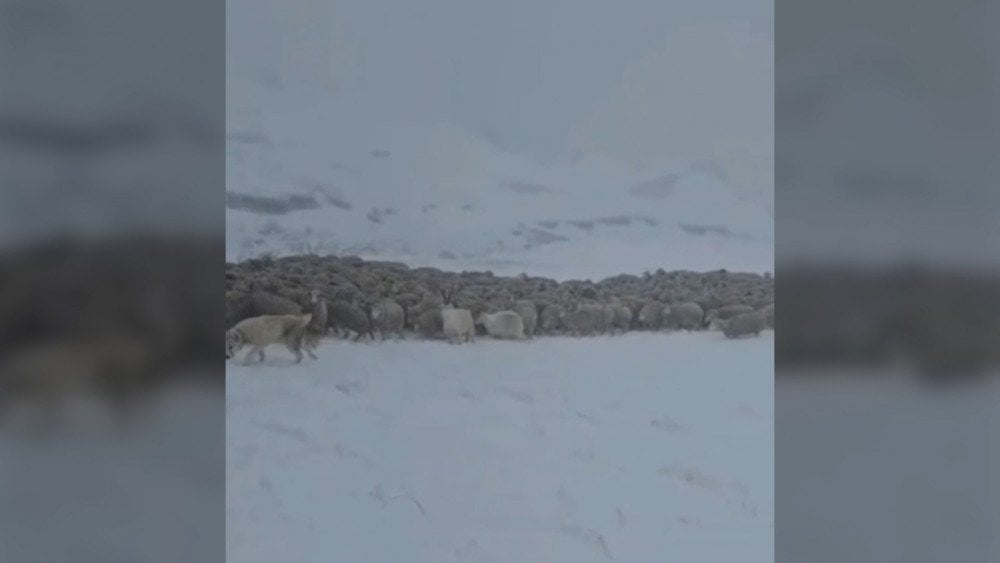
In the mountains of Dagestan, a flock of sheep was trapped in snow — Russia
Turkey
On September 18, large-scale wildfires once again engulfed southern and western Turkey. The most intense blaze broke out in the resort province of Antalya. Fanned by strong winds, the flames spread rapidly across mountain slopes and forested areas, turning popular tourist destinations into disaster zones.
Large resources were deployed to extinguish the fire: 13 helicopters, 4 firefighting planes, and about 800 rescue workers.
A major fire ignited near the city of Alanya and quickly approached residential areas. Flames came dangerously close to the villages of Yaylakonak and Şıhlar. Fortunately, there were no fatalities, though one person suffered from smoke inhalation and was hospitalized.
In Antalya, residents from over 200 homes were evacuated due to the fires.
Another large wildfire broke out in the city of Belek, where bars and technical facilities caught fire on the grounds of the five-star hotel Titanic Deluxe Golf Belek.
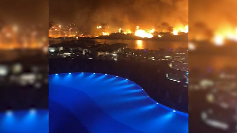
A wildfire approached a popular hotel in Turkey
Authorities decided to evacuate hotel guests and staff from the danger zone.
Argentina
A state of emergency was declared across the central provinces of Argentina after powerful storms struck during the night of September 20.
The worst-hit areas were the provinces of La Pampa, Buenos Aires, and Santa Fe.
In the city of Santa Rosa, La Pampa Province, a massive hailstorm turned streets into icy rivers. The size of the hailstones was shocking: in the towns of Ordóqui and around Trenque Lauquen, they reached the size of chicken eggs, and in some places — as large as tennis balls. Social media was flooded with videos showing hail bursting out of drainage systems, even erupting from toilets in residents’ homes, and tearing down gutters and pipes.
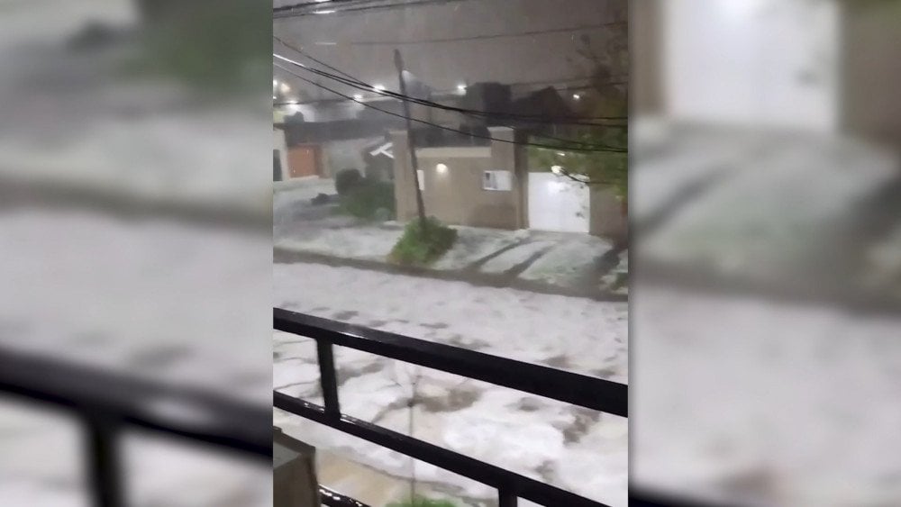
After the severe storm, the streets of Santa Rosa were covered with a thick layer of hail, La Pampa Province, Argentina
In Merlo, Buenos Aires Province, a family with three children was trapped inside their home after strong winds tore off a structure, which then collapsed onto the façade.
In Santa Fe Province, the cities of Cacique Ariacaiquín and La Brava were hit by squall winds that completely ripped the roofs off dozens of houses, forcing residents to evacuate urgently.
In Mendoza Province, snowfall and a temperature drop to −12 °C (10 °F) led to a two-day closure of the Cristo Redentor Pass — a key land route between Argentina and Chile.
Remarkably, despite the severe material damage, no casualties were reported.
Brazil
Last week, southern Brazil was hit by a series of storms with heavy rain and hail, affecting the states of Paraná, São Paulo, Rio Grande do Sul, and Santa Catarina.
Wind speeds reached critical levels for the region — at Campo de Marte Airport, gusts were recorded at up to 98 km/h (61 mph).
The wind knocked down trees and structures that were not designed to withstand such squalls. In the state of São Paulo, at least eight people were injured and sought medical attention, and in the city of the same name, the Bras metro station was closed due to the collapse of part of the roof.
In Paraná State, a woman was killed by a falling tree, and on September 20, a tornado swept through the small town of Barra Bonita in Santa Catarina, leaving behind a trail of destruction.
On September 22, at the Toyota plant in Porto Feliz, winds exceeding 100 km/h (62 mph) literally tore apart a massive warehouse building, injuring 10 people.
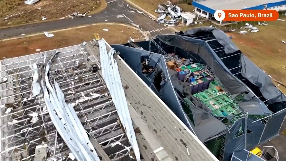
Powerful wind damaged a warehouse building at the Toyota factory in Porto Feliz, São Paulo State, Brazil
The aftermath of the storm was catastrophic: thousands of homes lost their roofs, while fallen trees and power lines paralyzed transportation and left millions without electricity — in Paraná alone, 1.1 million power outages were recorded.
Several cities also faced widespread water supply disruptions.
During the storm, an aviation incident occurred: on September 21, Latam Airlines flight LA3279, en route from Chapecó (Santa Catarina) to Guarulhos (São Paulo), encountered hail and severe turbulence shortly after takeoff, causing panic among passengers.
According to eyewitnesses, the incident lasted about 15 minutes and felt like a roller coaster ride. The experience was terrifying — the cabin was filled with screams and panic. The aircraft’s nose section was damaged, but it landed safely at its destination, and no one on board was injured.
Spain
On September 21, a Ryanair Boeing 737, operating flight FR4615 from Vitoria in northern Spain to Palma de Mallorca, encountered severe turbulence during its descent.
At that moment, all 180 passengers were already seated and wearing their seatbelts, which prevented injuries among them — but not among the flight attendants, who were still on their feet checking the cabin’s readiness for landing. Two of them were seriously injured: one was thrown upward and hit the ceiling, while another was struck by a food trolley. The remaining crew members sustained minor injuries. After landing, all were provided with medical assistance at the airport.
Eyewitnesses reported being shocked by the intensity of the turbulence, which arose suddenly after an otherwise calm flight.
Familiar air routes are turning into high-risk zones. According to a 2024 report by the International Civil Aviation Organization (ICAO), nearly 75% of all serious onboard injuries were caused by turbulence. The most tragic incident occurred in Brazil on August 9, 2024, when an ATR-72 aircraft operated by Voepass Linhas Aéreas, flying from Cascavel (Paraná) to Guarulhos (São Paulo), crashed within just one minute after plunging from an altitude of over 5 km (3.1 mi). All passengers and crew perished in the crash.
In recent years, research has recorded a significant increase in both the frequency and intensity of turbulence. This alarming topic has already been covered by major media outlets around the world. However, despite the clear trend, so-called “experts” continue to insist that turbulence is merely an inconvenience, not a serious safety threat.
There are several types of turbulence: convective, orographic, and the most dangerous and least studied — clear-air turbulence.
Convective turbulence occurs during convective storms, particularly thunderstorms.
Orographic turbulence arises when airflows interact with surface irregularities such as mountains and hills.
Clear-air turbulence (CAT) involves sudden, intense fluctuations of air currents that cannot be detected visually, since they occur in cloudless skies. This phenomenon cannot yet be forecasted or tracked by radar.
Modern science still does not understand the true nature of what is happening and currently attributes the emergence of clear-air turbulence to sudden changes in wind direction or speed.
However, this does not explain why aircraft entering such zones sometimes plunge dozens of meters (hundreds of feet) within seconds.
The heating of the atmosphere certainly plays a role in strengthening turbulence and jet streams, but the real causes lie much deeper — in electromagnetic anomalies associated with processes occurring within the Earth’s interior.
Back in April 2023, researchers of the ALLATRA scientific community presented findings on the nature of clear-air turbulence and the emergence of anomalous air pockets, issuing bleak forecasts about the growing intensity of this phenomenon.
According to their conclusions, disruptions in the Earth’s magnetic field within regions of atypical magnetic anomalies alter the ionization of atmospheric molecules, weakening the bonds between them — meaning that air itself ceases to provide lift for aircraft.
If humanity fails to take decisive action, a moment will come when neither airplanes nor helicopters will be able to rise into the air — or, if they do, there will be no guarantee they can land safely.
To ignore the rapid escalation of turbulence means to expose millions of people to deadly risk.
Sadly, in today’s societal model — where human life holds little value — such anomalies are neither studied seriously nor publicly discussed. On the contrary, they are kept secret as long as possible to avoid panic and protect profits. After all, how many airlines would dare to announce that flying has become dangerous?
Draw your own conclusions.
You can watch the video version of this article here:
Leave a comment