Summary of climate disasters on the planet: March 4 – 11, 2025
Each new natural anomaly shows how rapidly cataclysms are progressing throughout the world.
This article presents only a small part of the climate events that occurred in just one week, from March 5 to 11, 2025.
Argentina
On March 7, the forces of nature struck the provinces of central Argentina, bringing torrential rainfall—extreme in some areas—as well as severe storms with strong winds and hail. The greatest destruction occurred in the port city of Bahía Blanca, after about five months’ worth of rain fell in just a few hours—350 mm (13.8 in) of precipitation (the average monthly norm for March is 70.6 mm (2.78 in)).
This also set a new daily rainfall record—151 mm (5.94 in)—which doubled the previous maximum from 50 years ago, recorded on February 23, 1975.
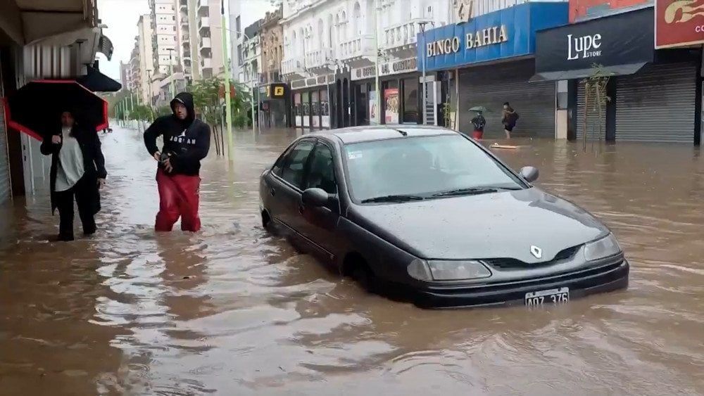
Record rainfall flooded the streets of Bahía Blanca, Argentina
Streets and entire districts of the city turned into raging rivers, with water levels exceeding one meter (3.28 ft). The currents were so powerful that people had to seek refuge on rooftops and even in trees.
Authorities cut off parts of the power supply to reduce the risk of electric shock. Public transportation was suspended, offices and government institutions were closed. The airport ceased operations due to water accumulation on the runway.
Residents of the city were in shock at how rapidly water entered their homes. Many lost furniture, appliances, and personal belongings. Shop owners suffered major losses—the disaster destroyed their stores and inventory.
The regional intensive care hospital, Dr. José Penna Hospital, was seriously affected. Ambulances in the garage were flooded. Critically important departments, including neonatal care, were inundated, and the staff had to evacuate newborns. Nurses carried infants, still connected to medical equipment, to safe areas.

Medical staff evacuate infants from flooded hospital, Bahía Blanca, Argentina
As of March 9, the destructive storm had claimed the lives of at least 16 people, with dozens reported missing. More than 1,400 residents were evacuated from the affected areas.
People experienced fear and vulnerability in the face of the disaster, and the destruction was so extensive that the timeline for the city’s recovery remains uncertain.
It is worth noting that this is already the second large-scale climate disaster to hit Bahía Blanca in the past 15 months. In December 2023, a storm with strong winds caused destruction in the city and claimed 13 lives. At that time, it took 45 days to restore the city.
Ecuador
Less than four months ago, Ecuador was suffering from a severe drought, but today the country faces the opposite extreme—powerful and prolonged rains have caused floods, landslides, and ground failures.
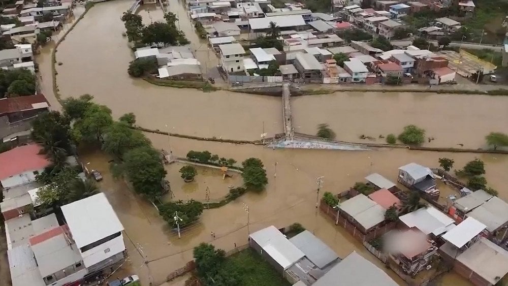
Widespread flooding in Ecuador
In March, the western and southern provinces of the country were especially affected by the disaster: Manabí, Guayas, Los Ríos, El Oro, Esmeraldas, Loja, and Chimborazo, where 22 rivers overflowed their banks, and in another 25 rivers, water levels rose rapidly.
A red level of danger was declared in 6 provinces.
On March 8 in the city of Portoviejo, Manabí Province, extreme rainfall fell within an hour, and in some areas the water reached the neck of an adult person.
On March 10, heavy rains caused damage in Loja Province in southern Ecuador. The Malacatos River, which flows through the city, overflowed its banks. Floodwaters swept people away in the streets and destroyed a bridge in Simón Bolívar Park.
Since early February of this year, rains have damaged 16 bridges, more than 23,000 houses, destroyed thousands of hectares of crops, and killed nearly 50,000 animals. According to the National Secretariat for Risk Management (SNGR) as of March 10, the disaster has already claimed at least 18 lives, with a total of 83,699 people affected.
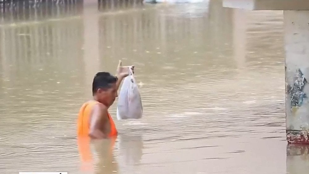
A man makes his way out of a catastrophic flood zone, Manabí province, Ecuador
Tropical Cyclone Alfred
Tropical Cyclone Alfred formed on February 22 in the Coral Sea, 1,300 km (808 mi) north of Brisbane, Australia.
According to meteorologists, Alfred was expected to dissipate over the ocean, as is typical for cyclones moving along similar trajectories.
However, on March 4 it suddenly veered westward toward the Australian coast, and three days later made landfall near Brisbane, the country’s largest city by area and third-largest by population. Its strength was equivalent to a tropical storm according to the U.S. National Weather Service classification, or a Category 2 storm on the Australian tropical cyclone intensity scale.
Tropical cyclones very rarely reach this far south along Australia’s eastern coast, where densely populated regions are located. The last time something similar happened was half a century ago, when Tropical Cyclone Zoe struck Australia’s coast near the border of Queensland and New South Wales in 1974.
The cyclone’s slow movement caused torrential rains, storm surges, and strong winds in coastal areas several days before landfall.
In some areas of the country’s east coast, total rainfall over five days exceeded 1,000 mm (39.37 in).
In Queensland, the city of Gold Coast and its famous canal network were among the first to be hit. In Upper Springbrook, 1,111 mm (43.74 in) of rain fell. Floodwaters turned city streets into rivers, and bull sharks appeared in the overflowing waterways. Destructive wind gusts reaching 100 km/h (62 mph) toppled trees and tore roofs off buildings.
On March 10, Brisbane recorded 275.2 mm (10.83 in) of rain in just one day, making it the wettest day in 50 years.
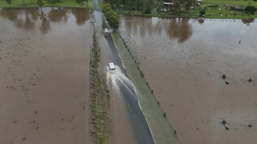
Tropical cyclone Alfred caused severe flooding in Australia
As a result of the storm, 330,000 homes and businesses in Queensland lost power. No other natural disaster has caused a more widespread power outage in the region’s history.
Tragedy struck in New South Wales: in the town of Dorrigo, a strong current swept a person away.
Kazakhstan
On the evening of March 7, residents of the city of Almaty witnessed a rare natural phenomenon—a snowfall accompanied by thunder and lightning. Eyewitnesses admitted that they saw this for the first time in their lives, and some even mistook the rumble for the sound of an earthquake beginning.

Snowfall with thunder and lightning in Kazakhstan
USA
An EF2 tornado struck Seminole County, Florida, on the morning of March 10. Wind speeds exceeded 185 km/h (115 mph). The National Weather Service called this tornado a rare event for Central Florida, where only 10% of such twisters reach EF1 or EF2 strength.
The tornado left a trail of destruction about 6.5 km (4 mi) long. In the city of Longwood, one house was completely destroyed, and several others were severely damaged. Trees were downed throughout the area, power lines were damaged, and debris was scattered.
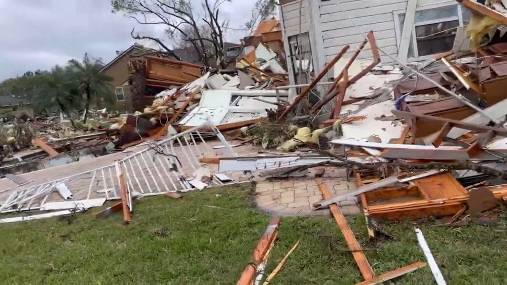
Aftermath of a destructive tornado, Seminole county, Florida, USA
The FOX 35 TV studio, located in Lake Mary, was in the storm’s direct path. During a live broadcast, while the anchor was reporting the approaching threat, the tornado suddenly passed directly over the building. Fortunately, the structure withstood the force of the storm, and those inside were unharmed. However, both witnesses and viewers of the channel experienced genuine shock at how suddenly anyone can find themselves at the heart of a disaster.
Spain
Another powerful tornado struck the Spanish municipality of La Algaba in Seville Province on March 8, frightening local residents. People unfamiliar with this phenomenon mistook the roar of the storm for a plane crash. The wind tore off roofs, damaged buildings and power lines. The industrial zone was especially hard hit—according to preliminary estimates, one company alone suffered damages exceeding €200,000.
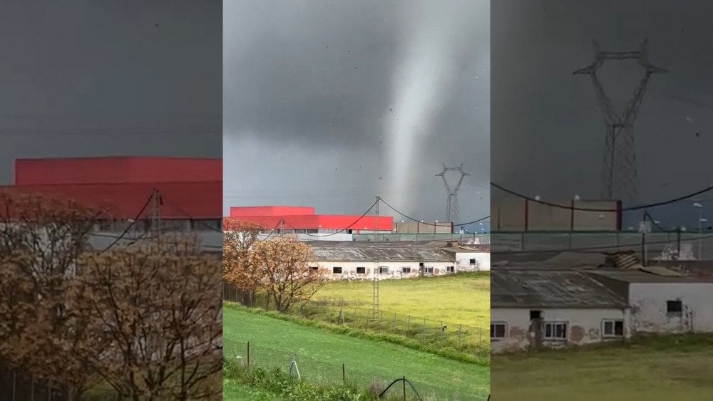
Powerful tornado in La Algaba, Seville province, Spain
Temperature Anomalies
In early March, Europe experienced an anomalous heatwave, with temperatures more typical of May. In some countries, deviations from the norm exceeded 12°C (21.6°F).
In Croatia on March 6, the air temperature in the city of Zadar reached +20°C (68°F).
In Lithuania on March 6, the Druskininkai weather station recorded a new national daily record—+18.4°C (65.1°F). This is 4°C (7.2°F) higher than the previous record set 30 years ago.
In Latvia, the beginning of March became the warmest on record. For five consecutive days, temperatures reached record highs.According to the Latvian Environment, Geology and Meteorology Centre, over 60 temperature records were broken.
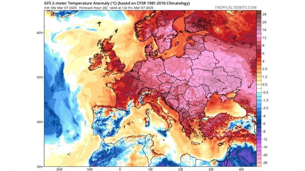
Anomalous heat recorded across Europe in March
In Belarus, all 48 weather stations in the country recorded temperatures above the absolute maximums for early March.
Maximum temperatures in Belarus: Minsk — +16.9°C (62.4°F); Brest — +18.4°C (65.1°F); Pinsk — +18.5°C (65.3°F); Gomel — +18.8°C (65.8°F); Bobruisk — +17.6°C (63.7°F); Samokhvalovichi — +19.7°C (67.5°F).
Ukraine was also in the epicenter of the heatwave. Maximum temperatures were recorded in the following cities: Kyiv — +19.2°C (66.6°F), Chernihiv — +18.7°C (65.7°F), Rivne — +16.6°C (61.9°F), Zhytomyr — +18.3°C (64.9°F), Chernivtsi — +21.4°C (70.5°F). In the city of Ivano-Frankivsk, on March 6, the temperature nearly reached the typical highs of July and August, the hottest months of the year—+22.9°C (73.2°F).
In Belgium, the commune of Uccle broke the 1892 record with a temperature of +19.1°C (66.4°F).
And in the United Kingdom, due to the anomalously warm weather, a large wildfire broke out on the heather moorlands in Greater Manchester County.
Turbulence
On March 8, an incident occurred in the sky involving Turkish Airlines flight TK759 from Dubai to Istanbul. Some passengers reported that during the flight, the airliner entered a zone of severe turbulence, which felt like a sudden free fall.

Chaos on board Dubai–Istanbul flight after encountering severe turbulence
The increasing frequency of turbulence incidents, unusual behavior of storms and tropical cyclones, prolonged droughts, extreme rainfall, shifts in typical wind patterns, and sharp temperature anomalies—all of this is the result of an imbalance in the ocean-atmosphere system, caused by the record heating of the World Ocean.
If no action is taken, in the near future we can expect the emergence of new, even more extreme climate events that go far beyond the previous norms.
To address this global issue, the efforts of scientists, policymakers, businesses, and, without a doubt, the public must be united. Through shared effort and resources, we can develop and implement comprehensive solutions.
But it’s important to understand that action must be taken together, as one humanity!
Leave a comment