Summary of Climate Disasters on the Planet, March 16–22, 2026
A terrifying storm struck a megacity in Pakistan.
Hawaii was hit by its worst flood in 20 Years.
A rare and powerful tropical cyclone unleashed chaos in Australia.
And the Canary Islands — the islands of eternal spring — have seen snowfall.
In this episode, you will learn what climate events took place around the world from March 16 to 22, 2026, and what lies behind them.
Spain
On March 18, the unusually powerful Storm Therese struck the Canary Islands, unleashing real chaos. The region, beloved by tourists for its sunshine and mild climate, found itself in the grip of extreme weather. The disaster paralyzed transportation: dozens of flights were canceled or diverted, and ports were closed.
In Tenerife, in the area of Izaña, wind gusts reached 122 km/h (76 mph). The Teide National Park was blanketed in snow, and icicles began to form in resort areas. Meanwhile, the average minimum temperature in March in this region is 15 °C. +15°C (59°F).
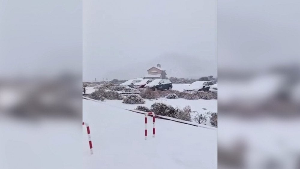
A rare snowfall for this region occurred on the island of Tenerife, Spain
Due to the snowfall, roads were closed. In the north of the island, a landslide damaged a water supply canal, causing water outages.
On the island of Lanzarote, in the municipality of Arrecife, waves up to 5 m (16 ft) high destroyed waterfronts, piers, and beach infrastructure.
Off the coast of the island of Fuerteventura, near the town of Corralejo, two people in a boat were rescued from the raging sea.
On the island of Gran Canaria, record-breaking rainfall was recorded, triggering flash floods and landslides. In the municipality of Vega de San Mateo, more than 100 mm (3.9 in) of rain fell in less than 24 hours. A massive boulder blocked the main mountain road GC-60.
The Canary archipelago has a volcanic origin: its islands are cut through by deep dry ravines that, during heavy rains, within minutes, can turn into raging torrents carrying rocks and mud, posing a serious threat to people.
In the municipality of Mogán, rainwater flooded a ravine, leaving about 200 residents of the town of Arguineguín isolated.
Torrential rains during Storm Therese caused flooding on the island of Gran Canaria, Spain
The flooding damaged a pumping station in the municipality of La Aldea de San Nicolás, leaving residents without water.
In Gáldar, the Los Pérez dam overflowed — for the third time in its entire history.
Pakistan
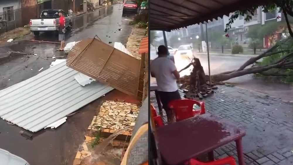
On the evening of March 18, a powerful storm struck Pakistan’s multi-million city of Karachi, in Sindh Province.
Nearly all districts of the mеgacity were affected: in the Maripur area, winds reaching 97 km/h (60 mph) uprooted trees and power poles, tore off roofs and billboards.
The storm damaged 645 transformer feeders, causing 70% of the power supply system of the utility company K-Electric to fail, leaving most of Karachi without electricity.
In one district, a building wall suddenly collapsed, which, according to eyewitnesses, had already been weakened by recent rains. Dozens of people were buried under the rubble. By late night, the bodies of 19 victims had been recovered. Local residents transported the dead and injured to the city hospital on their own.
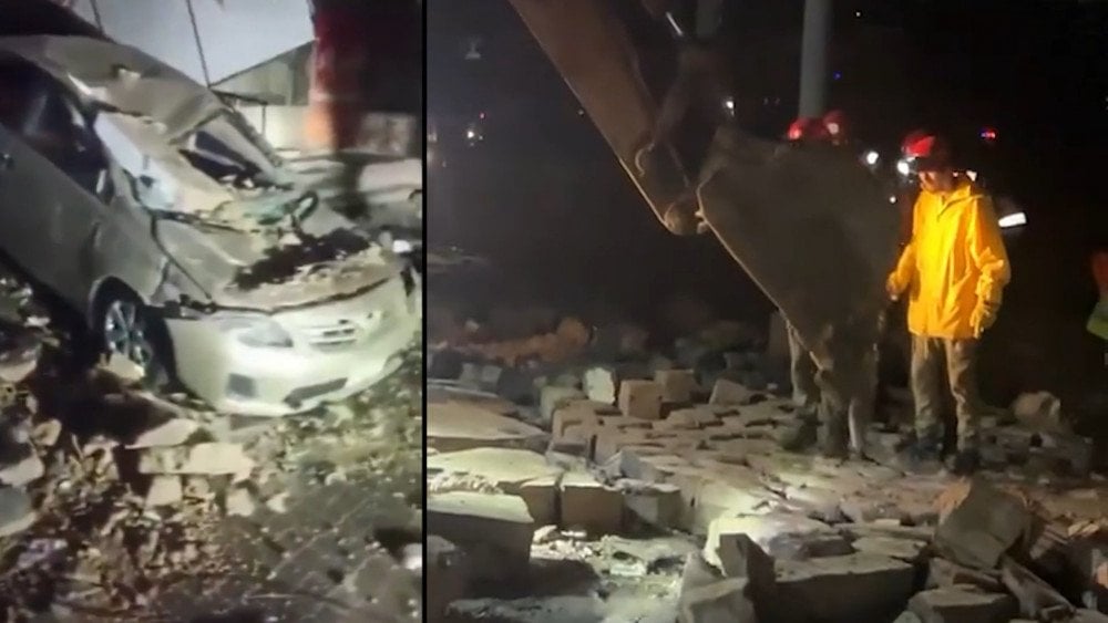
The storm caused severe destruction in Karachi, Pakistan
In rural areas of Sindh Province and border regions of Balochistan, torrential rains and hail destroyed crops, mango orchards, and date plantations.
In several districts of Balochistan Province, lowlands were flooded, while landslides on mountainous sections of highways N-50 and N-70 complicated traffic.
In the city of Karachi and other parts of Sindh, storm winds, thunderstorms, and hail killed at least 24 people, while 60 others were injured.
United States
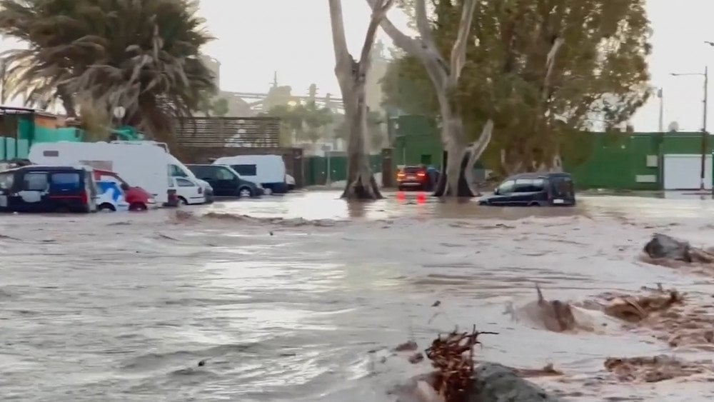
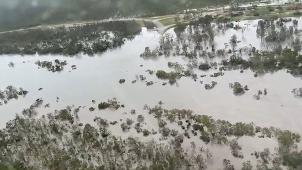
Starting on March 16, Hawaii experienced its most severe flooding in more than 20 years. The cause was a “Kona Low” cyclone — an atmospheric system that disrupts the usual wind circulation and brings prolonged torrential rains to the islands.
The storm hit hardest in Oahu and Maui, the two most popular tourist islands in the archipelago. In less than 48 hours, up to 500 mm (19.7 in) of rain fell in some areas onto soil already saturated by previous rainfall. Rivers burst their banks, and large areas—including residential neighborhoods and resort areas—were flooded. More than 5,500 people in northern Oahu were ordered to evacuate.
The Hawaii National Guard was deployed to help people trapped by the rapidly rising water. Rescuers evacuated people from rooftops and pulled them from flooded homes. Emergency response teams rescued more than 200 people.
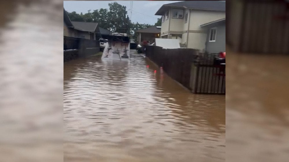
A “Kona Low” cyclone caused severe flooding in Hawaii, United States
On March 20, authorities declared a state of emergency due to the imminent threat of a dam breach on the northern coast of Oahu.
As a result of the disaster in Hawaii, hundreds of homes were damaged. Roads, schools, hospitals, and other public facilities were also affected.
Preliminary damage exceeded one billion dollars.
Malawi
Starting on March 16, torrential rains struck Malawi, causing destructive flooding and landslides across the country.
The disaster damaged infrastructure: roads were eroded, and water and power supply systems were disrupted — 588 power poles collapsed and 111 transformers were damaged.

Flooding destroyed a road in Malawi
At hydroelectric power plants, part of the equipment had to be shut down in order to clear debris carried by rivers. As a result, power generation at the Nkula Hydroelectric Power Station decreased by 25 MW.
In Lilongwe District in Malawi’s Central Region, a major landslide occurred, covering about 36 hectares (89 acres). The area became unsuitable for living and agriculture. The rapid rise of water also led to the deaths of livestock and poultry.
In Nkhata Bay District in the country’s Northern Region, the port was seriously damaged.
In the city of Mangochi, Southern Region, two children died while trying to cross an overflowing river.
As of March 19, the disaster had claimed at least 13 lives across the country, while dozens of people were injured.
Brazil
In mid-March, a cyclone formed over the Atlantic off the southeastern coast of Brazil and remained almost stationary for five days. According to meteorologists, the reason for such unusual behavior was a blocking anticyclone that prevented the cyclone from moving into the open ocean. This disruption in air mass circulation led to the formation of destructive storms in several Brazilian states.
In the state of Mato Grosso do Sul, torrential rain struck the city of Maracaju on March 18. Within one hour, it saw 121 mm (4.8 in) of rain. Floodwaters inundated a public school, a wholesale supermarket, and residential homes. Streets turned into rivers, and traffic jams formed at the entrance to the BR-267 roundabout.

Torrential rains flooded a supermarket in the city of Maracaju, Mato Grosso do Sul State, Brazil
From March 16 to 18, the city of Santarém, Pará State, saw 168 mm (6.6 in) of rain, which makes up 52% of the average March monthly norm of 325.5 mm (12.8 in).
More than 2,000 residents in 19 districts found themselves in disaster zones, while over 430 people lost their homes.
On March 21, an extratropical cyclone off the coast of Argentina triggered dangerous weather conditions in the Brazilian state of Rio Grande do Sul. At a time when the region was experiencing heat close to 40°C (104°F), hurricane-force winds and heavy rains struck the area. In the municipality of Lajeado, wind gusts reached 107 km/h (66 mph).
In the city of Uruguaiana, the disaster tore roofs off buildings, toppled trees and power poles: in the city center, a swimming pool collapsed from the roof of a building, while in the União das Vilas district, power lines that had sagged after the storm snagged a motorcyclist while he was riding.
Aftermath of hurricane-force winds in Rio Grande do Sul State, Brazil
In the municipality of Alegrete, metal sheets from a damaged building were blown through the streets. In Restinga Sêca, the ERS-149 highway was blocked due to fallen trees, while in the municipality of Taquari, more than 10,000 homes were left without electricity. In the city of Passo Fundo, a tree fell onto a bus and a car.
On March 22, torrential rains exceeding 100 mm (3.9 in) caused flooding in the northern part of the state: 101 mm (4 in) of rain fell in the city of Quatro Irmãos, and 90 mm (3.5 in) fell in the city of Coxilha.
Australia
Tropical Cyclone Narelle formed on March 16 in the Coral Sea, off the coast of Queensland. Rapidly intensifying, it reached Category 4, but shortly before landfall it weakened slightly and on March 20 struck the coast of North Queensland with sustained winds of around 200 km/h (124 mph), corresponding to a Category 3 tropical hurricane on the Saffir–Simpson scale. By March 19, Tropical Cyclone Narelle had reached Category 5 on the Australian tropical cyclone intensity scale.
This was the first storm system of such strength to affect the Cape York Peninsula since 1899.
Fortunately, Narelle passed between the major settlements of Lockhart River and Coen without causing significant damage there. In the Archer River area, north of Coen, 400 mm (15.7 in) of rain fell in less than 24 hours. The water level beneath the recently built Archer River Bridge rose from 5 to 13 m (16.4 to 42.7 ft) within just a few hours.
Tropical Cyclone Narelle caused severe flooding in Queensland State, Australia
Due to downed power lines, hundreds of homes were left without electricity. Mobile communication was also disrupted. Storm surge flooding inundated coastal roads all the way to the city of Cairns, washing trees, sections of promenades, pedestrian walkways, and benches away into the ocean. On some beaches, winds and tides created large sand drifts.
Many roads were closed due to debris and overflowing rivers and streams. Cooktown Airport remained the only accessible transport hub for delivering people and cargo to isolated communities.
The tourist town of Port Douglas, known as the gateway to the famous Great Barrier Reef and the Daintree Rainforest, also felt the impact of the tropical cyclone: the beach was severely eroded despite being located about 400 km (249 mi) from where Narelle made landfall.
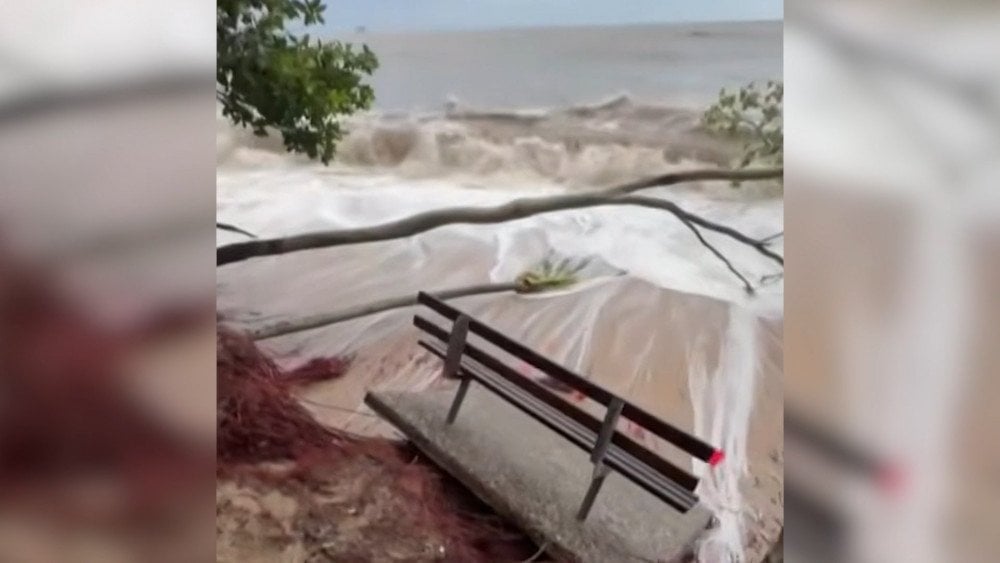
Tropical Cyclone Narelle caused storm surge that washed away part of a beach and toppled trees in Queensland State, Australia
Australia’s Northern Territory was also affected by the disaster. On the night of March 22, the cyclone struck the eastern part of the Top End, where people had still not recovered from recent flooding.
In the city of Katherine, many buildings had already been cleared of mud and debris, but cleanup operations were partially suspended due to the threat of upcoming flooding. The city’s mayor said that volunteers were simply exhausted: for two weeks they had tirelessly helped restore areas devastated by the previous wave of flooding, and now they were forced to return to clear the same places again and again.
Soon the cyclone weakened into a tropical depression, but as it moved westward, it continued bringing torrential rain and strong winds. During the 24 hours leading into the morning of March 23, more than 202.5 mm (8 in) of rain fell in the town of Adelaide River.
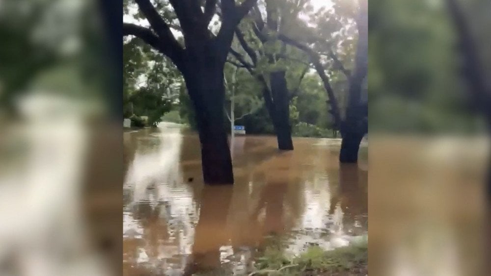
Flooded areas of the town of Adelaide River, Australia, after the passage of Tropical Cyclone Narelle
As a precautionary measure, hundreds of residents of the remote settlement of Numbulwar were evacuated to the city of Darwin.
It is worth noting that ocean temperatures along Narelle’s path were 1–2°C (1.8–3.6°F) above average, which was one of the reasons for the cyclone’s unusual strength in the region. The Coral Sea, where the cyclone formed, is one of the ocean areas that has warmed by nearly 0.5°C (0.9°F) in recent decades, according to climatologist Andrew Watkins, adjunct professor at Monash University and member of the Climate Council.
In recent years, the ocean has been warming faster than expected. Recent studies show that warming is occurring not only at the surface, but also in deep bottom layers.
The ocean floor is an active geological medium through which thermal energy is constantly transferred into the water. Underwater volcanoes, faults, mid-ocean ridges, and hydrothermal vents create a true “deep heating circuit” of the planet. When Earth’s geodynamic activity intensifies, as is happening today, the upward heat flow increases, and the ocean receives additional energy.
Despite the existence of numerous studies confirming the significant contribution of geothermal energy to ocean warming, this factor is still barely considered in most climate models.
Why is this important? Because the ocean is the planet’s thermal regulator. It redistributes and dissipates heat, stabilizing the climate. But today, its cooling capacity is being disrupted by micro- and nanoplastics. These particles hinder the natural release of heat, turning the ocean into an “energy trap.”
As a result, the number and intensity of natural disasters across the planet are already increasing rapidly. And it’s just the beginning.
We cannot wait until disasters reach an entirely new level, when megastorms, megatornadoes, and megahurricanes become the norm.
If we fail to act now, the consequences of increasing geodynamic activity and humanity’s interference with natural processes through plastic pollution could become far greater than anything humanity has ever faced before.
Watch the video version of this article here:
Leave a comment