Dangerous Manifestations of Climate Disasters in 2024 | Part 3
Part 3
In this article summarizing the climate outcomes of 2024, we will focus on storms and some lesser-known atmospheric anomalies that have impacted different regions of the planet.
The past year has tested humanity’s resilience. It brought not only natural disasters with devastating aftermath but also entirely new manifestations of natural forces—phenomena that specialists encountered for the first time.
But most importantly, it is already clear what can be done right now to counter this threat.
Storms
Recently, and especially in 2024, storms have become extremely powerful, spreading across vast territories.
On December 7, Storm Darragh brought chaos to multiple countries in Western Europe: Ireland, the United Kingdom, the Netherlands, France, Germany, and Belgium.

Fallen trees during Storm Darragh blocked railway tracks in France
Ferry services between Ireland and the United Kingdom were completely halted. This dealt a major blow to logistics in both countries, as 90% of goods arriving in Ireland are transported via ferry routes.
Thousands of flights were canceled or rerouted. Fallen trees and utility poles blocked railway tracks and highways.
Winds reaching speeds of up to 150 km/h (93 mph) caused widespread Internet and mobile network outages, leaving more than 2 million homes and businesses in Ireland and the United Kingdom without power.
A 120-meter (394-foot) barge ran aground off the coast of France after hurricane-force winds pushed it across the English Channel from the United Kingdom.
In September 2024, Storm Boris brought powerful winds and torrential rainfall to Central and Eastern Europe. It became one of the 10 costliest climate disasters of 2024 worldwide. The affected countries included Austria, Poland, the Czech Republic, Romania, Slovakia, Hungary, Moldova, Ukraine, and Germany.
In the Austrian Alps, winds reaching 146 km/h (91 mph) and nearly 48 hours of continuous snowfall created extreme conditions. In the mountains of Tyrol, snowdrifts reached heights of 1 meter (3.3 feet) in some areas.
In Romania, on September 14, nearly 160 mm (6.3 inches) of rainfall was recorded. Rescuers evacuated people by boat, and a helicopter was deployed for emergency response.
In the Polish town of Stronie Śląskie, located in the Lower Silesian Voivodeship, a dam breach led to the collapse of a bridge and the flooding of streets and homes.
The Czech Republic was hit hardest. In some regions there, over half a year’s worth of rainfall—463.7 mm (18.3 inches)—fell in just four days, as recorded at the Jeseník meteorological station.
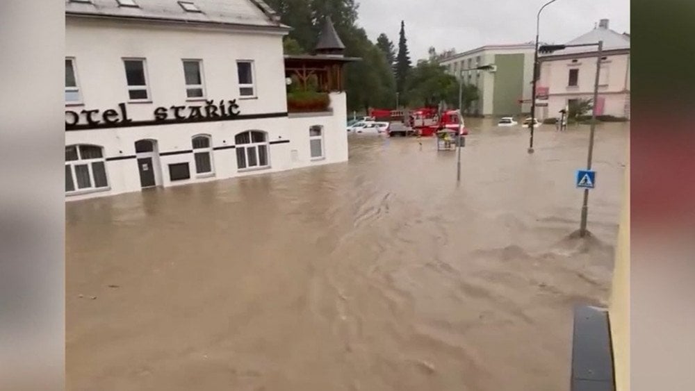
Large-scale flood after Storm Boris, Czech Republic
Towns and villages in the Jeseníky Mountains were submerged as raging floodwaters rose up to 2 meters (6.6 feet) in some areas, cutting them off from the outside world. Northern and Southern Moravia were particularly hard-hit.
Across 8,500 km (5,280 miles) of European rivers, water levels doubled the average annual peak.
Storm Boris managed to unleash an enormous amount of rain because it became trapped between two high-pressure zones, remaining stationary for an extended period.
In Australia, a storm system described by meteorologists as a “rain bomb” also moved extremely slowly. On December 30, it struck Queensland, delivering an extraordinary amount of rainfall for the region. In some areas of Hervey Bay, up to 180 mm (7.1 inches) of rain fell overnight.
In Kingaroy, located in the South Burnett region, a December record of 149 mm (5.9 inches) of rain was set within 24 hours (on December 30, 2024).
Most of it—120 mm (4.7 inches)—fell in just two hours. One of the most dangerous characteristics of this storm was its rapid intensification within just one hour. This is why many people were caught off guard. Homes and businesses were flooded. On some roads, water levels reached 1 meter (3.3 feet).
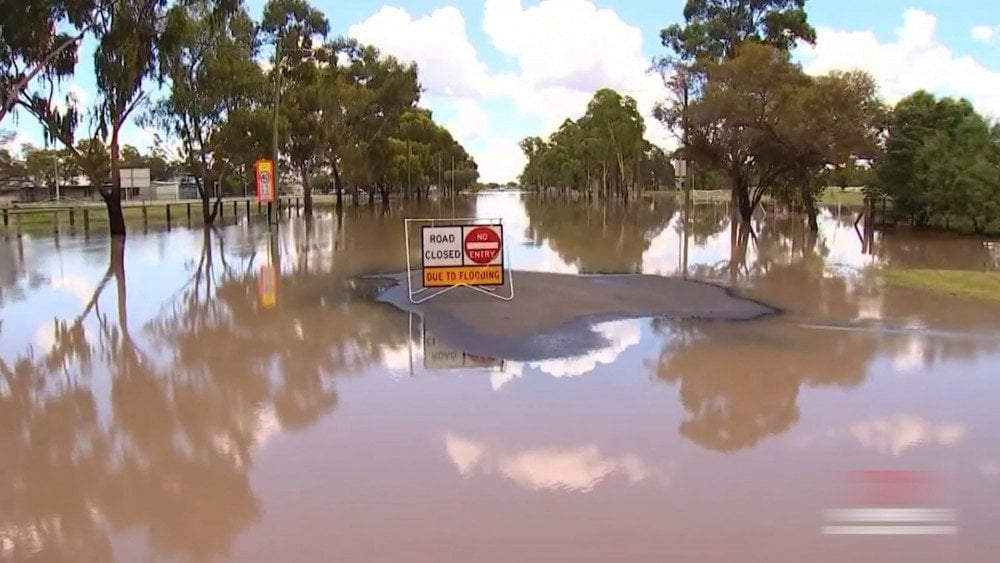
Flooded city of Kingaroy after the storm, described by specialists as a “rain bomb,” Australia
Meteorologists estimate that such extreme floods occur no more than once in 100 years.
The storm that struck the Pacific coast of the United States and Canada on November 19 was classified as a “bomb cyclone” due to its rapid development. Its intensification rate was twice the threshold required for this classification.
This storm became one of the most severe ever recorded in the region. Its aftermath was worsened by the simultaneous impact of a powerful atmospheric river.
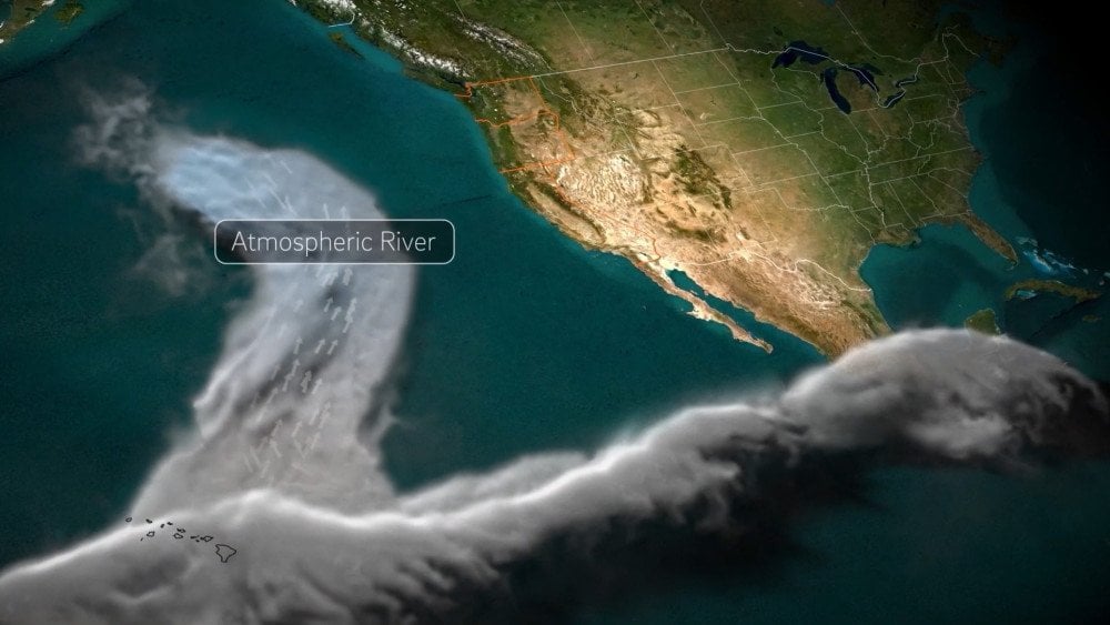
Model of the atmospheric river forming and developing. Source: Scripps Institution of Oceanography
An atmospheric river is a powerful, narrow stream of moisture in the atmosphere capable of delivering enormous amounts of precipitation to coastal areas—comparable to the flow of a major river.
When these two phenomena interacted, they intensified each other, making the situation unpredictably dangerous.
One of the alarming characteristics of recent storms is their ability to rapidly gain strength while moving slowly, inevitably leading to torrential rainfall. A similar trend is observed in tropical cyclones. More details on this can be found in Part 2 of the Annual Summary of Climate Disasters.
Wind during storms is increasingly reaching speeds typical of tropical cyclones.
On March 31, the city of Fuzhou in Jiangxi Province, China, was hit by a convective storm with wind speeds comparable to a Category 1 tropical cyclone—35.9 m/s (129.2 km/h or 80.3 mph). This set a record for the region.
On April 6 and 7, a powerful storm struck Western Cape Province, South Africa. Winds reaching 44 m/s (158.4 km/h or 98.4 mph) blew trucks off a bridge. According to the hurricane scale, this corresponds to Category 2.
On March 28, Storm Nelson brought wind gusts of 50.8 m/s (183 km/h or 113.7 mph) to Brittany, France, which is equivalent to a Category 3 hurricane.
On March 14, a powerful cyclone hit southern Kamchatka, Russia. The wind knocked people off their feet, uprooted trees and traffic lights, and easily blew cars off the roads. Wind gusts reached 60 m/s (216 km/h or 134.2 mph)—equivalent to a Category 4 hurricane!

A structure overturned by powerful hurricane winds, Kamchatka, Russia
The unusual intensity of storms is also evident in the phenomenon known as “lake-effect snow.”
This phenomenon frequently occurs in the U.S. and Canada when Arctic cold air collides with the abnormally warm waters of the Great Lakes.
However, at the end of November, the amount of snowfall during this event was simply staggering.

Abnormally high snow accumulation, Northeastern U.S.
A powerful multi-day blizzard swept across the Northeastern U.S. and Ontario, Canada. In the U.S., the most affected states were Pennsylvania, Ohio, Michigan, and New York.
In some areas, snow fell at a rate of up to 10 cm (4 inches) per hour, setting absolute records. On November 29, a record daily snowfall of 57 cm (22.4 inches) was recorded in Erie, Pennsylvania, U.S.. From November 30 to December 2, Barnes Corners, New York, U.S., received 167 cm (65.7 inches) of snow in just three days. Meanwhile, in Gravenhurst, Ontario, Canada, an unprecedented 140 cm (55.1 inches) of snow fell.
Road traffic was paralyzed. The snowstorm was accompanied by thunderstorms and waterspouts—phenomena that are extremely rare during cold seasons.
The lake-effect also occurred in Italy when, in December, the cold air from Storm Elena passed over the warm waters of the Adriatic, triggering anomalous downpours along the coast and heavy snowfall in the Apennine Mountains.

Impassable road after an extreme snowfall, Campo di Giove, Abruzzo Region, Italy
During the Christmas holidays, the Abruzzo Region was completely snowed in. In Campo di Giove, the snow depth reached nearly 1.5 meters (4.9 feet).
From December 23 to 27, Storm Elena affected several other European countries, including Italy, Slovenia, Croatia, Bosnia and Herzegovina, Serbia, and Greece.
In Croatia, hurricane-force winds destroyed the country’s largest solar power plant, which had been built just a year earlier near Obrovac. The plant covered 14.5 hectares (35.8 acres) and had a generation capacity of 5 MW.
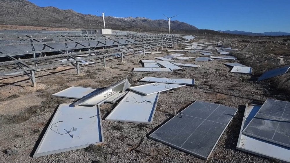
The largest solar power plant in the country completely destroyed by storm winds, Croatia
In some areas of Serbia, extreme snowfall halted railway traffic for five days.
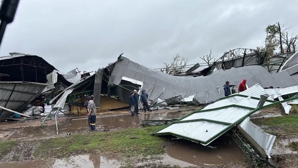
Storm-force winds, torrential rains, and heavy snowfall paralyzed life in Bosnia and Herzegovina, turning many regions into disaster zones. In Eastern Drvar, power supply and mobile communications were lost, while snowdrifts reached several meters, blocking roads. Even ambulances were unable to reach patients.
Modern storms have become so unpredictable that forecasting them is an increasingly difficult challenge. Experts are making more and more frequent miscalculations in predicting storm behavior. This is deeply concerning, as less time remains for preparation.
On December 14, just a day before Subtropical Cyclone Bigua made landfall in Brazil, forecast models showed completely different storm development scenarios, leaving meteorologists at a loss.
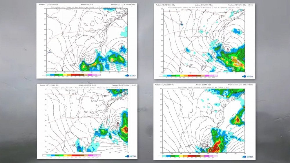
Completely different predictive models for the development of the subtropical cyclone Bigua, Brazil
It brought strong winds with speeds of up to 100 km/h (62 mph) to the state of Rio Grande do Sul , which left 230,000 consumers without electricity and caused infrastructure damage in several cities.
In April, powerful storms rarely hit the UK. Over the last 10 years, only one similar event had occurred—Storm Hannah, which struck the country in April 2019.
However, in April 2024, the UK experienced two such events within just three days.
On April 5, Storm Kathleen paralyzed airports, railway services, and ferry transportation. Wind speeds exceeded 31 m/s (112 km/h or 69.5 mph).
Just three days later, on April 8, the southern regions of the UK were hit by Storm Pierrick, which triggered a massive tidal surge. Coastal areas were devastated by powerful waves.

Huge waves caused by Storm Pierrick destroying coastal areas, United Kingdom
Another unseasonal event was recorded in southern Africa. Snowfall is extremely rare in the region—it occurs only in mountainous areas during winter and usually does not cause serious consequences.
However, in 2024, starting on September 20, snowstorms hit Lesotho and South Africa. Snowdrifts in some areas reached 2 meters (6.6 feet). The Eastern Cape, KwaZulu-Natal, Free State, and Gauteng provinces in South Africa were particularly affected. This snowfall was unexpectedly late and abnormally intense, exceeding even the mid-winter norm (winter in the Southern Hemisphere lasts from June to August). Even more astonishing for residents was the snowfall on November 5 in Eastern Cape Province, as summer had already begun in the country by that time.

Snowy summer in the Southern Hemisphere, Eastern Cape Province, South Africa
Recently, and particularly in 2024, there has been a noticeable surge in the activity of severe thunderstorms, also known as convective storms, across various regions of the world. Higher ocean temperatures and increased air humidity have created ideal conditions for the formation of such storms. These storms are accompanied by squall winds, torrential rains, hail, and frequent tornado outbreaks.
The formation of thunderstorms is becoming increasingly rapid and difficult to predict.
On April 7, a severe storm struck Bangladesh. In some areas, it lasted only 15 minutes, but within that time, it destroyed more than 750 homes and severely damaged agriculture. In Bhola District alone, more than 7,000 people were affected, and 13 lost their lives. The storm was not forecasted in advance, and many farmers were killed by lightning strikes while working outdoors.

Destruction caused by storm winds, Bhola District, Banglades
The combination of destructive natural phenomena during severe thunderstorms results in immense economic losses, increasingly comparable to the damage caused by hurricanes.
A report by Munich Re, the world’s largest reinsurance company, states that severe thunderstorms caused enormous damage: in the USA alone, they were responsible for US$ 57bn in losses. This is only slightly below the 2023 record of $66 billion.
From May 6 to May 9, a series of powerful convective storms struck the central U.S. The National Weather Service (NWS) issued over 300 warnings for life-threatening conditions, including lightning, large hail, and destructive wind gusts. Additionally, more than 60 tornado warnings were issued. In Oklahoma, a storm spawned an extremely dangerous EF4 tornado, causing massive destruction in the city of Barnsdall. This storm outbreak alone resulted in $6.6 billion in damages.

Aftermath of an extremely powerful tornado in Barnsdall, Oklahoma, U.S.
In July, an Austrian insurance company estimated the total damage from a hailstorm in Vorarlberg at approximately €1.2 million. More than 5,000 hectares (12,355 acres) of crops were destroyed.
During severe thunderstorms, hail becomes more intense, and hailstones grow larger.
On May 24, in Turin, Italy, record-breaking hail fell. Roads were completely covered, paralyzing traffic. Snowplows had to clear the hail drifts.

Streets turned white after a hailstorm, Turin, Italy
From May 15, prolonged hailstorms swept across much of France. Thousands of hectares of vineyards were severely damaged, leading to near-total crop loss in some areas.
On May 19, in Lublin Voivodeship, Poland, the storm completely destroyed agricultural crops.
On May 20, in the village of Buitenpost, Friesland Province, Netherlands, rain and hail were so intense that they began flooding buildings through the drainage system.
Massive hailstones damage property, destroy crops, and now threaten people's health and even lives.

X-ray images of a skull fracture caused by a large hailstone, sustained by a girl in Sabinas, Coahuila, Mexico
In Slovenia, the July hailstorm damaged roofs of houses, numerous vehicles, and destroyed photovoltaic power stations.
On March 25, a severe convective storm struck Zhejiang Province, China. In Yiwu County, wind speeds reached at least 32.7 m/s (117.7 km/h or 73.1 mph), hitting the highest level on the Beaufort scale (Category 12).
Massive hailstones, the size of eggs, caused significant damage to vehicles: windshields were shattered, and car bodies were dented with large impacts. PICC received 11,400 claims related to hail damage to vehicles. Some people were injured by the large hailstones.
Meteorologists calculated that an egg-sized hailstone weighing just 30 grams (1.06 ounces), falling from a height of one kilometer (0.62 miles), hits with the force of a 3-kilogram (6.6-pound) weight dropped from 10 meters (32.8 feet).

Large hail damaged the roof of a building in Guangzhou, China (left).
Giant hail in Solís de Mataojo, Lavalleja Department, Uruguay (right)
On April 26, Uruguay was struck by severe storms. Several departments were hit by large hail. In Solís de Mataojo, Lavalleja Department, hailstones reached 8 cm (3.1 inches) in diameter. They dented cars and damaged roofs of houses.
On the same day, in the Río Negro River area, strong wind gusts caused significant destruction, toppling hundreds of trees. Experts struggled to determine the exact cause of the phenomenon. One hypothesis suggests that it may have been a microburst.
Destruction caused by extremely strong winds, Uruguay
In recent years, microbursts have been occurring with alarming frequency. These phenomena form due to a downward airflow, which, upon hitting the ground, generates intense horizontal wind gusts reaching up to 250 km/h (155 mph). This is equivalent to dumping an enormous bucket of water from the sky over a radius of about 5 km (3.1 miles). As a result, microbursts can cause damage comparable to that of a moderate tornado.
On June 8, in Cartago, Costa Rica, strong winds tore off the roof of the “Fello Meza” Stadium. According to experts from the National Meteorological Institute (IMN), this was a “downward microburst.”
A similar event occurred in early November during Cyclone Martina in Russia, affecting Lotoshino and Ruza urban districts in Moscow Oblast. The powerful wind gusts left countless broken trees, and two roofs from residential buildings were torn off and thrown approximately 100 meters (328 feet) from the structures.
Microbursts are capable of causing massive destruction over a localized area, which is exactly what happened on October 12 in the state of Goiás, Brazil, in the municipality of Três Ranchos. A sports field was completely destroyed, reduced to a pile of debris, as if it had been hit by an explosion. At the same time, nearby buildings—including fragile solar panels—remained undamaged.

“Microburst” destroyed a sports field in the municipality of Três Ranchos, Goiás, Brazil
Microbursts are still unpredictable, making them extremely dangerous.
Turbulence
The destabilization of the atmosphere not only triggers extreme weather events but also intensifies turbulence, which poses a serious problem for air travel. The sharp increase in cases of severe turbulence leading to injuries of varying severity can no longer be ignored.
On March 11, during a flight from Sydney, Australia, to Auckland, New Zealand, 50 people were injured due to severe turbulence. 12 of them were hospitalized.
On March 29, a United Airlines aircraft had to make an emergency landing at an airport in northern New York State. 22 passengers were injured, seven of whom were taken to hospitals.
On April 3, during a Southwest Airlines flight from New Orleans to Orlando, two people were injured due to turbulence.
For the same reason, on August 11, six flight attendants on EVA Air flight BR 238 from Jakarta to Taipei sustained injuries.

Chaos inside an EVA Air aircraft flying from Jakarta to Taipei after severe turbulence
Starting July 1, Korean Air discontinued in-flight service 40 minutes before landing, recommending that passengers always keep their seatbelts and belongings fastened. This rule was introduced after the number of turbulence-related incidents nearly doubled in 2024. According to global turbulence statistics for South Korea’s national airlines, in Q1 2023, 3,473 cases were recorded, while in Q1 2024, the number surged to 6,246 cases.
This is just one part of the story. The year 2024 has been marked by numerous aviation incidents. What is particularly concerning is that planes are now suddenly losing altitude more frequently. Back in April 2023, at the Global Crisis: There Is a Way Out forum, scientists predicted that due to the emergence of atypical magnetic anomalies, flights would become nearly impossible because airliners would start falling into air pockets. Unfortunately, this prediction is coming true.
A Madrid–Montevideo Air Europa flight was forced to make an emergency landing in Natal, Brazil. After entering a turbulence zone, the aircraft suddenly began losing altitude. In a matter of seconds, passengers experienced sheer terror. Those who were not wearing seatbelts were thrown into the cabin ceiling, and one person became trapped in the overhead luggage compartment. Approximately 30 people sustained injuries and were hospitalized, four of whom were placed in intensive care.
A London–Singapore flight plummeted nearly 2,000 meters (6,562 feet) in just three minutes. Many passengers smashed their heads through overhead compartments. The crew managed to execute an emergency landing in Bangkok airport.

Emergency situation inside the aircraft flying from London to Singapore after a rapid loss of altitude
Of the 229 people on board, 104 were injured, with six in critical condition, mostly suffering head injuries. One passenger died during the incident after suffering a heart attack.
Another aviation disaster ended in tragedy.
On August 9, a Voepass Linhas Aéreas ATR-72 aircraft, operating flight 2283 from Cascavel (Paraná) to Guarulhos (São Paulo), crashed over a residential area in Vinhedo Municipality. 57 passengers and 4 crew members were killed. Within one minute, the aircraft plunged from 5,181.6 meters (17,000 feet).

Moment of impact and burning wreckage of the Voepass Linhas Aéreas ATR-72 after the crash
The flat spiral trajectory in which the plane descended, according to aviation expert Lito Souza, is unprecedented.
Currently, all such incidents are classified as either technical failures or clear-air turbulence.
However, the main cause remains overlooked, while the number of aviation incidents is rising as rapidly as global climate catastrophes. After all, these are interconnected links of the same chain.
One of the key drivers of the escalating climate disasters is the overheated ocean, which transfers energy to the atmosphere, intensifying destructive cataclysms. Some researchers warn that without intervention, the situation could lead to catastrophic consequences for all living beings.
To address the climate crisis, it is crucial to investigate all contributing factors behind ocean heating. It is also necessary to accelerate the adoption of technologies that could help cool the ocean and thus improve the global climate situation.
The primary focus should be on atmospheric water generators, which have the potential to significantly improve global conditions within 2–3 years if widely implemented. Such actions require international cooperation. Scientists, policymakers, businesses, and society must unite their efforts.
This innovative approach to solving the climate crisis was presented at COP16 in Colombia. More details can be found in the documentary “Climate Crisis and Ocean Pollution: Global Challenges and Solutions.”
You can watch the video version of this article here:
Leave a comment