Summary of Climate Disasters on the Planet, March 8–15, 2026
Wind overturned dozens of trucks in the USA.
Lava from the Piton de la Fournaise volcano reached the ocean.
A landfill collapse in Indonesia. Crocodiles on flooded streets in Australia.
The largest deep-focus earthquake in Italy.
More details are provided below in the summary of past week’s climate events, from March 8 to 15, 2026.
We will also reveal the dangers hidden deep within our planet’s interior.
Australia
Torrential tropical rains struck the Top End region in Australia’s Northern Territory, triggering severe flooding.
Over five days, from March 4 to 9, 571.5 mm (22.5 in) of rainfall was recorded at the Daly River Police Station weather station; around 241 mm (9.5 in) fell at Katherine Bridge, while central and western areas received 100–200 mm (3.9–7.9 in).
The most severe aftermath was recorded in the town of Katherine, which experienced its worst flood in the past 28 years. Water inundated streets and low-lying areas, damaging homes, businesses, and urban infrastructure.
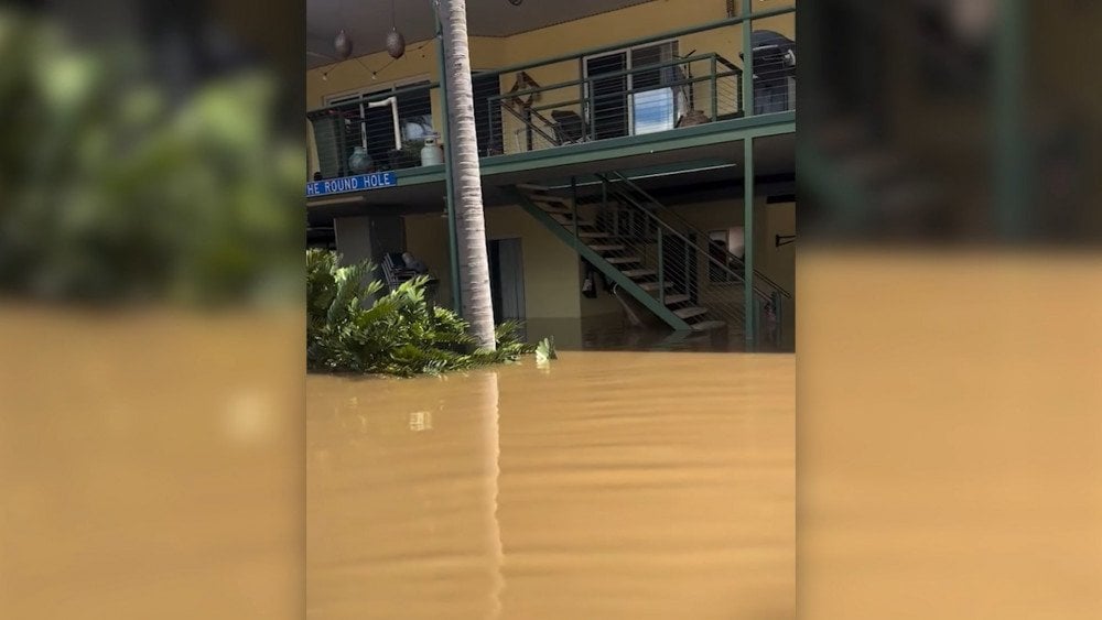
Flooding in Australia: a building submerged after torrential rains
The disaster also affected small remote communities surrounding Katherine. Some of them had to be evacuated for the second time this year. About 300 residents of the town of Daily River returned home just two weeks ago following the previous disaster. But the catastrophe struck again: more than 570 mm (22.4 in) of rain fell here within five days, causing the most severe flooding ever recorded in the region.
As of 3:45 PM on March 13, the water level at the gauge near the Daly River Police Station reached 16.26 m (53.3 ft), slightly exceeding the previous record of 16.25 m (53.3 ft) set in 1998.
People were rescued from vehicles and homes using boats and helicopters.
In flooded areas, especially along the Daly River and in Katherine, both saltwater and freshwater crocodiles were spotted — some even in residential neighborhoods and on the local football field. The city’s mayor admitted that she had never seen so many reptiles after a flood before.

After severe flooding in Katherine, Australia, crocodiles appeared on the streets
More than 100,000 crocodiles inhabit the Northern Territory, and when muddy floodwaters inundate urban streets, they become a serious threat to people.
Powerful downpours also rapidly raised water levels in rivers across the state of Queensland, triggering floods in several river basins simultaneously.
Over three days, extreme rainfall totals were recorded: 396 mm (15.6 in) in Boondooma, a rural area in the South Burnett Region; 381 mm (15.0 in) in Marodian, a rural district in the Fraser Coast Region; 279 mm (11.0 in) in the suburb of Bundaberg South; 263 mm (10.4 in) in the city of Gympie.
The disaster severely disrupted transportation: around 760 roads across the state were damaged.
The most critical situation developed in the city of Bundaberg, where the Burnett River overflowed its banks, flooding hundreds of homes and businesses. Key bridges connecting the northern and southern parts of the city were closed, leaving around 10,000 people cut off from the outside world.
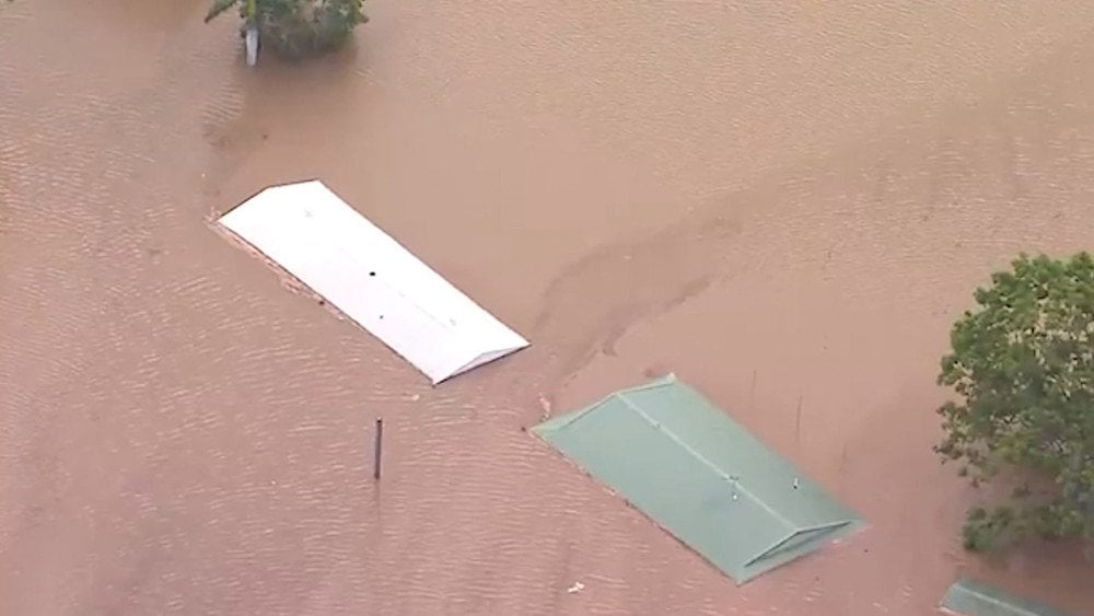
Aftermath of record rainfall in Bundaberg, Australia: buildings completely submerged under water
On March 12, in the Wide Bay–Burnett region near the town of Kilkivan, two tourists from China were found dead in a flooded car.
The flooding caused severe damage to the region’s agriculture: around 1,200 head of cattle perished, and more than 1,000 km (621 mi) of fencing was damaged.
USA
On March 10, a powerful storm system unleashed a series of tornadoes across the Midwestern United States.
One of the most destructive twisters struck the small town of Lake Village. The EF3 tornado tore directly through residential neighborhoods. Footage from the scene shows streets where buildings were literally ripped apart, with fragments of roofs and walls scattered across yards and roads.
According to emergency services, more than 100 homes sustained severe damage, while around 30 were completely destroyed.
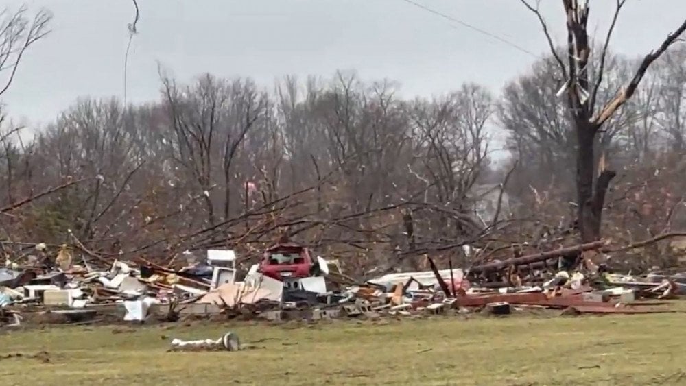
A powerful tornado ripped buildings apart and snapped trees in Lake Village, Indiana, USA
The tornado also brought down trees and power lines, leaving parts of the town without electricity.
As a result of the disaster, an elderly couple lost their lives. Another 11 people were injured.
The same storm system also brought another rare weather phenomenon to the region — giant hail in Illinois. Some ice stones reached 15 cm (5.9 in) in diameter. Residents shared photos and videos showing hailstones barely fitting into the palm of a hand. According to meteorologists, such a size could set a new state record.
The hail damaged vehicles, shattered windows, and destroyed rooftops.

Giant hail fell in Illinois, USA
On March 12, a massive storm front stretching more than 3,000 km (1,864 mi) struck the western and central United States, affecting around 80 million people.
In the town of Centennial, Wyoming, wind gusts reached 175.4 km/h (109 mph; 48.7 m/s). The wind tore roofs off homes and damaged power lines. At the height of the storm, more than one million households in Minnesota, Wisconsin, Illinois, and Michigan experienced widespread power outages.
In the state of Colorado, the storm triggered a dust storm and sharply reduced visibility. On highways, powerful crosswinds overturned dozens of heavy trucks, and after several such accidents, about 50 km (31 mi) of Interstate 25 was closed to traffic.
On March 14, a powerful cyclone formed over the central United States. More than 50 cm (19.7 in) of snow fell within 24 hours in Minnesota and Wisconsin. Strong winds caused blizzard conditions and drastically reduced visibility on roads.
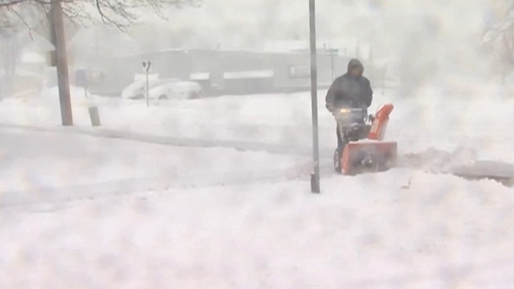
The USA under the grip of a cyclone: blizzards and snowstorms paralyzed transportation as crews worked to clear sidewalks
In Minnesota alone, police recorded more than 100 traffic accidents. Severe weather also seriously disrupted air travel: more than 600 flights were canceled at Minneapolis–Saint Paul International Airport, while delays also affected other major airports across the region.
Ethiopia
On March 10, after several days of torrential rainfall, devastating floods and landslides struck the Gamo Zone in the South Ethiopia Region. The districts of Kamba, Gacho Baba, and Bonke were the hardest hit.
Water-saturated mountain slopes suddenly collapsed during the night while people were sleeping, burying villages beneath thick layers of mud and debris.
As a result, around 190 homes were destroyed, roads were blocked, and bridges were flooded. Vast areas of farmland were devastated.
More than 3,400 residents were forced to flee their homes and take shelter in churches and other public buildings.
Relentless downpours complicated search-and-rescue operations. One person was pulled out alive after spending three days trapped beneath a landslide.
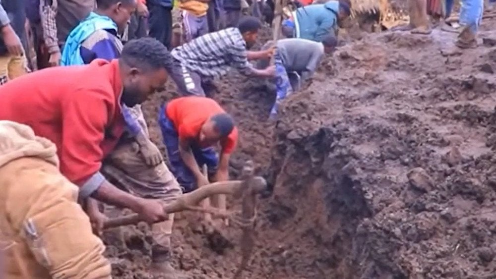
Search-and-rescue operations after a landslide in southern Ethiopia
As of March 14, at least 107 people had lost their lives. Dozens more remain missing.
Indonesia
On March 8, a massive landfill collapse occurred at the Bantargebang landfill — the largest waste processing site in Southeast Asia — located in the city of Bekasi.
The landfill has been operating since 1989 and covers an area of around 110 hectares (272 acres). Up to 8,000 tons of waste from Jakarta, the country’s capital, are delivered there every day. In some places, the waste mounds exceed 50 m (164 ft) in height — comparable to a 16-story building.
The landslide was triggered by torrential rains that had continued for several days. Particularly intense rainfall — 264 mm (10.4 in) within 24 hours — was recorded on March 8. Water penetrated deep into the waste mass, making it unstable and causing the layers to shift.
The catastrophe occurred while several trucks were waiting to unload. A gigantic mountain of waste about 50 m (164 ft) high buried five garbage trucks and a coffee kiosk. The landslide also blocked the landfill’s service road and covered around 40 m (131 ft) of the Ciketing River channel.
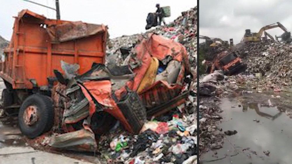
Torrential rains triggered a landfill collapse — garbage trucks were buried under debris in Bekasi, West Java Province, Indonesia
During the rescue operation, 19 excavators and 7 ambulances were deployed. Six people were pulled out alive from beneath the debris. Sadly, seven others could not be saved.
Seismic and Volcanic Activity
A new extremely powerful eruptive episode occurred at the Kīlauea volcano in Hawaii. According to the United States Geological Survey Hawaiian Volcano Observatory (HVO), on March 10 lava fountains inside the Halemaʻumaʻu Crater exceeded 400 m (1,312 ft) in height.
The ash cloud rose to an altitude of around 9 km (5.6 mi), disrupting flights at Hilo International Airport.
During nine hours of continuous eruption, volcanic rocks fell across communities near Kīlauea, with some fragments reported to be as large as a soccer ball. For safety reasons, certain sections of Highway 11 were closed.
In Hawaiʻi Volcanoes National Park and near the Volcano Golf Course, continuous ashfall and thin strands of volcanic glass — known as Pele’s hair — were also observed. These fibers pose a danger to the respiratory system.
One person with asthma experienced breathing difficulties and sought medical assistance.
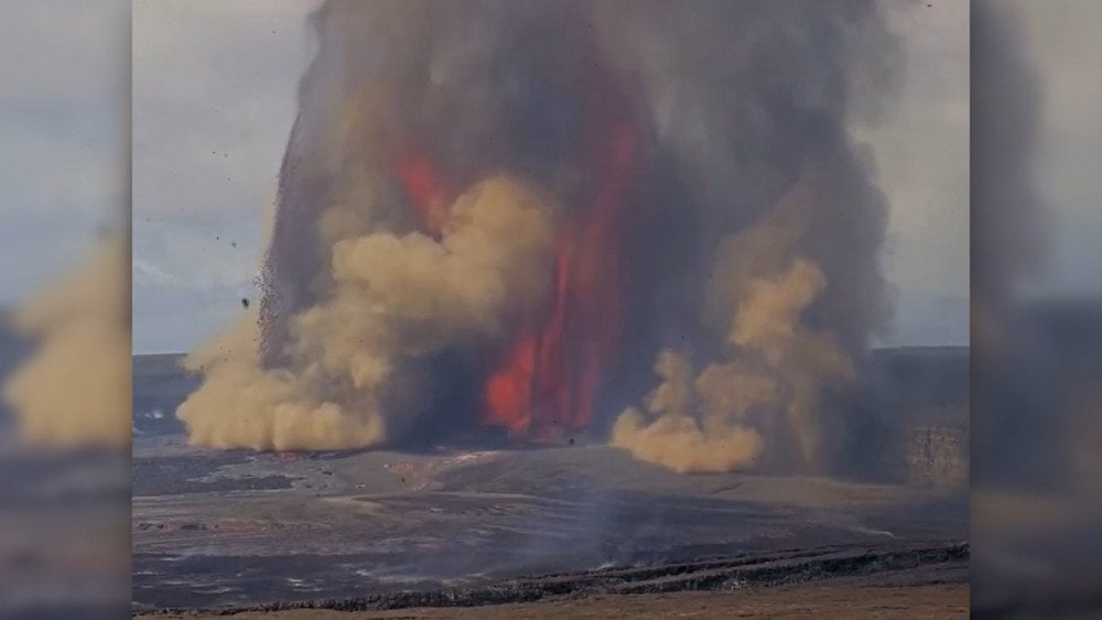
Eruption of Kīlauea volcano, Hawaii, USA
After nearly a month of continuous eruption, a lava flow on one of the slopes of the French volcano Piton de la Fournaise entered a new phase.
On the morning of March 12, the lava resumed movement and approached the RN2 national highway. It advanced at a speed of approximately 25–30 m/h (82–98 ft/h), gradually descending the southeastern slope of Grand Brûlé toward the ocean.
Then, on March 13, for the first time in almost 20 years, the lava flow crossed the highway, completely cutting off transportation between the southern and eastern parts of the island, and continued moving toward the coastline.
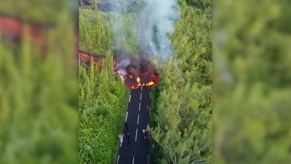
The lava flow from Piton de la Fournaise volcano crossed the highway, Réunion Island, France
The flow reached approximately 15 m (49 ft) in width and nearly 1.5 m (4.9 ft) in height.
According to the Piton de la Fournaise Volcanological Observatory, the volcano’s magmatic system continues to be replenished with magma, sustaining the eruption.
During the night of March 16, the lava reached the ocean. When the basaltic lava came into contact with seawater, dense plumes of steam mixed with volcanic gases and tiny glass-like particles formed.
The resulting so-called “laze” — acidic steam containing hydrochloric acid and particles of volcanic glass — can irritate the eyes and respiratory tract and reduce visibility.
A strong odor spread through the surrounding area, while the irritating gas caused burning sensations in the eyes and throat. Around 50 people were relocated to a safe zone. However, tourists continue to visit the area despite strict restrictions prohibiting access to the trail.

The glowing lava flow of Piton de la Fournaise volcano, France, attracts the attention of a tourist
According to the National Seismological Center, on the morning of March 13 at 10:39 LT, a powerful M6.5 earthquake struck off the coast of Chile. The epicenter was located 41 km (25.5 mi) southwest of the city of Huasco in the Atacama Region. The hypocenter lay at a depth of around 26 km (16.2 mi). The earthquake was felt across a vast territory — from Atacama to Valparaíso, including the capital, Santiago. Particularly strong shaking, reaching intensity VI on the Mercalli scale, was recorded in the cities of La Serena, Coquimbo, and La Higuera.
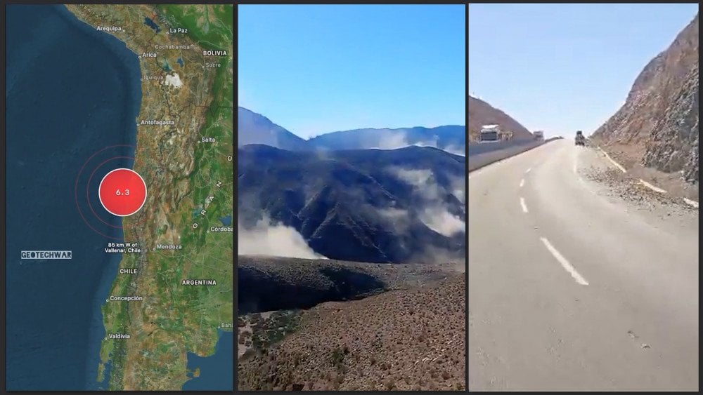
Powerful earthquake off the coast of Chile
The Mercalli scale is a macroseismic intensity scale that classifies the strength of earthquake shaking based on observed effects: people’s sensations, structural damage, and changes in the natural environment. The scale consists of 12 intensity levels (I–XII).
Residents reported that the shaking lasted almost four minutes. A series of aftershocks followed the main quake.
Rockfalls and small landslides occurred in areas near the epicenter. No reports of casualties or major destruction were received.
On March 13 at 03:35 LT, an M5.5 earthquake was recorded in the Niksar district of Tokat Province in northern Türkiye. The hypocenter lay at a depth of 6.37 km (4 mi).
Seismic tremors were also felt by residents of neighboring provinces: Samsun, Amasya, Çorum, Ordu, Sivas, and Sinop. As a result of the disaster, plaster crumbled in some buildings and suspended ceilings were damaged. Small cracks also appeared in the walls of a regional boarding high school.
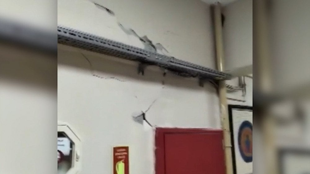
Aftermath of the earthquake in Tokat Province, Türkiye: cracks appeared in building walls
The nighttime earthquake triggered widespread panic. Residents left their homes and remained outside until morning, fearing aftershocks.
People described the intense fear and anxiety they experienced in their comments. Several individuals sought medical attention due to stress and minor injuries sustained during evacuation.
As a precautionary measure, schools in Tokat Province were closed for one day.
Echoes of the March 13 earthquake in Türkiye were also felt by residents of Sochi in Russia. Witnesses wrote on social media that tremors were felt early in the morning in the city’s Central and Adler districts.
It is important to note that increased seismic activity had already been observed off the coast of Sochi in March this year. According to the Unified Geophysical Service of the Russian Academy of Sciences, a series of M4.4–4.7 tremors occurred in the Black Sea within 20 km (12.4 mi) of the coast: on March 3 at 12:09 LT — M4.4; on March 3 at 13:05 LT — M4.7; and on March 6 at 04:29 LT — M4.5. In all cases, the hypocentral depth was 10 km (6.2 mi).
People reported chandeliers swaying and windows rattling inside homes. Fortunately, there were no casualties or infrastructure damage.
According to specialists, throughout the entire period of instrumental observations in this part of the Black Sea basin, such series of earthquakes with magnitudes above 4 had never previously been recorded.
On March 9, a strong deep-focus M5.9 earthquake occurred near Naples beneath the Tyrrhenian Sea.
Deep-focus earthquakes are a poorly studied type of seismic activity characterized by hypocenters located at depths greater than 300 km (186 mi).
According to the Italian National Institute of Geophysics and Volcanology (INGV), the hypocenter of the event was located at a depth of 410 km (255 mi). Due to the great depth, seismic waves propagated over a vast distance, and the tremors were felt across the Italian Peninsula — from Naples to Milan and Verona.
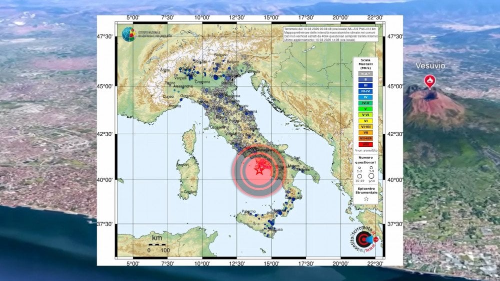
The epicenter of the deep-focus earthquake in Italy on the map showing the intensity of the tremors
The earthquake also affected railway traffic. As a precautionary measure, some trains in Rome were temporarily canceled. On lines north of Naples, infrastructure inspections caused travel delays of up to 1.5 hours.
The March 9 seismic M5.9 event became the largest deep-focus earthquake ever recorded in this region.
This event is just one manifestation of processes occurring deep within our planet. Let us briefly examine the physics behind these phenomena.
Excess energy that has appeared in the Earth’s outer core directly affects the geodynamics of the mantle — causing it to melt with increased intensity. It is precisely this melting of mantle material that leads to deep-focus earthquakes occurring at depths greater than 300 km (186 mi), and today reaching even 800 km (497 mi).
For a long time, the mechanism behind these phenomena remained unclear to scientists, because at the enormous temperatures and pressures present at such depths, quakes would seemingly be impossible. The mantle material must undergo plastic deformation rather than brittle fracture like it occurs in the Earth's crust. Nevertheless, such seismic events are now being recorded regularly.
According to the hypothesis of ALLATRA scientists, deep-focus earthquakes represent powerful intra-mantle explosions.
They often serve as triggers for strong earthquakes in the Earth’s crust, amplifying their destructive effects, and can also provoke volcanic eruptions.
The danger of these processes also lies in the enormous volume of released energy. Intra-mantle explosions transform mechanical energy into thermal and electrical energy, generating powerful electromagnetic impulses. These impulses propagate through the Earth’s layers and reach the atmosphere, causing disturbances in the magnetic field and redistribution of electrical charges.
Thus, deep-focus earthquakes are capable of triggering an entire cascade of dangerous processes on the Earth’s surface. Their real threat remains seriously underestimated, while the number of such events continues to grow exponentially.
Watch the video version of this article here:
Leave a comment