Summary of climate disasters on the planet, August 13–19, 2025
Billions of people live behind an information curtain; they know nothing about the real climate situation on the planet or about what awaits humanity in the near future.
In this episode, we will lift the curtain on statistics: how anomalies turn into the “norm” and why that leaves so many people misled.
Read the summary of climate disasters of the past week, from August 13 to 19, 2025 — and keep a calculator handy — we’ll be tallying up the figures that usually remain behind the scenes.
India and Pakistan
Since August 14, northern and northwestern Pakistan have been hit by catastrophic floods caused by monsoon rains.
The hardest hit was Khyber Pakhtunkhwa Province. The districts of Buner, Bajaur, Swat, Shangla, Mansehra, and Battagram were declared disaster zones. In Buner District, more than 100 mm (3.9 in) of rain fell in just one hour.
Powerful torrents of water with mud and huge boulders rushed down from the mountains. The disaster destroyed more than ten villages, damaged roads, and swept away vehicles. The flood was so sudden that people did not have time to leave their homes. According to local residents, they had never seen anything like this before.
On August 15, in the village of Kadar Nagar, a house where preparations for a wedding were underway was swept away. As a result of the tragedy, 28 people died.
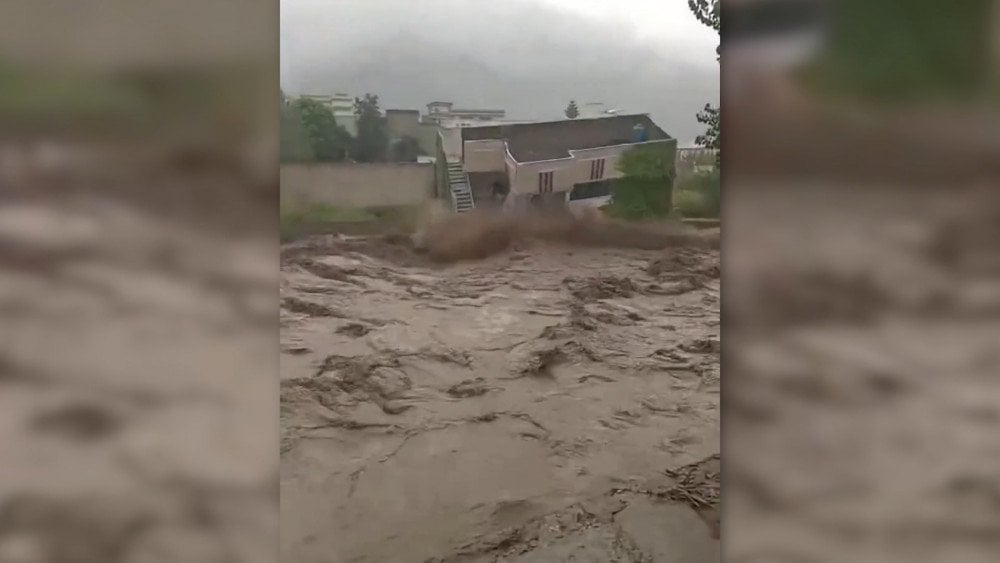
Catastrophic flood destroys houses in Khyber Pakhtunkhwa Province, Pakistan
More than 3,500 tourists were evacuated, and dozens are reported missing.
Due to damaged roads, dozens of villages were cut off from the outside world, and rescuers had to reach some affected areas on foot. About 2,000 rescuers were deployed.
On August 16, a rescue helicopter delivering humanitarian aid to the disaster zone crashed. All five people on board died.
Because of heavy rains and floods in the region, 780 houses were damaged, nearly half of them completely destroyed. As of August 19, the disaster claimed the lives of at least 358 people, and more than 180 others were injured.
Intense rainfall also led to severe flooding in Jammu and Kashmir, under India’s administrative control.
On August 15, in the remote Himalayan village of Chosoti (Kishtwar District), located on the route to the Machail Mata temple, a tragedy occurred.
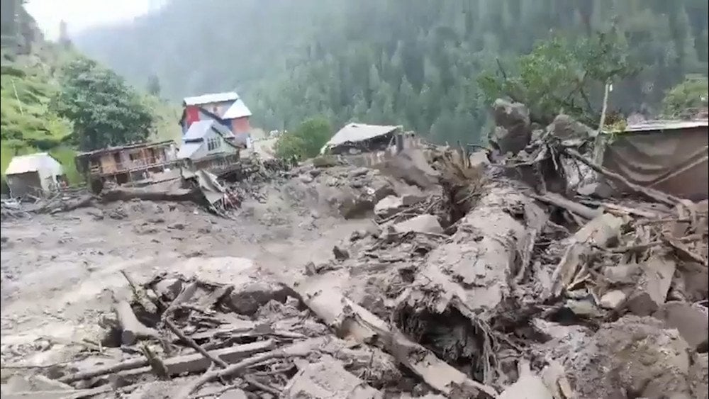
Aftermath of severe flooding in Jammu and Kashmir, under India’s administrative control
A sudden powerful torrent swept away a community kitchen with 200 pilgrims. At least 60 of them died, and about 80 are reported missing.
On August 16, sudden floods in two villages of Kathua District killed at least seven people, and another five were injured.
Indonesia
On August 17 at 6:30 LT in Central Sulawesi Province, a strong earthquake with a magnitude of 5.8 occurred. The epicenter was located in Tomini Bay, 13 km (8 mi) from the city of Poso. The hypocenter lay at a depth of 10 km (6.2 mi).
The shaking was felt in the city of Palu (the capital of Central Sulawesi Province) and in Poso and Morowali districts.
The tremors, lasting about 15 seconds, caused panic among residents — people hurriedly left their homes, fearing the collapse of buildings. Dozens of patients at the state hospital in Poso had to be evacuated and temporarily accommodated in tents on the hospital grounds.
In nine villages, at least 66 buildings collapsed: residential houses, schools, offices — electricity supply was disrupted. The Elim Masani community church in the village of Masani (Poso Pesisir District, Poso Regency) was especially hard hit: during a morning service, walls and beams collapsed onto the congregation — 12 people were injured and hospitalized, one woman later died in the hospital.

Destroyed building after the 5.8 magnitude earthquake in Central Sulawesi Province, Indonesia
In total, 41 people were injured, ten of them in serious condition.
Within 24 hours, 57 aftershocks with magnitudes up to 4.3 were recorded, so many residents did not dare to return home and remained outside.
Tropical Hurricane Erin
“Erin” entered Atlantic history as one of the fastest-intensifying and most powerful tropical hurricanes. On August 15, it was an ordinary storm, and just 25 hours later it turned into a Category 5 monster with wind speeds of nearly 260 km/h (162 mph). It was also unusual that it appeared in August, while such strong hurricanes usually form at the peak of the season in September.
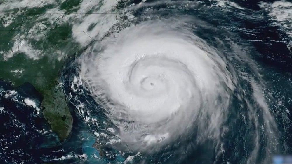
Powerful tropical hurricane “Erin” formed in the Atlantic
Although the islands of the Caribbean avoided a direct hit from the storm, on August 16 its periphery brought torrential rains and gusty winds to Puerto Rico and the British Virgin Islands. On Tortola Island, at least 220 mm (8.7 in) of rainfall was recorded.
In Puerto Rico, more than 150,000 people were left without electricity, and local authorities warned of dangerous floods and landslides.
The next day, the size of the hurricane began to increase rapidly, turning the system into a giant. By August 19, hurricane-force winds extended 130 km (81 mi) from the center, and storm-force winds up to 370 km (230 mi).
In the United States, a state of emergency with mandatory evacuation was declared in Dare County, North Carolina, where coastal resorts are located on the narrow island chain. Mandatory evacuation was announced on Hatteras Island.

Hurricane “Erin” destroys a building in North Carolina, USA
Powerful surf waves and deadly rip currents caused dozens of rescue operations.
Russia
In mid-August, in one of the northernmost settlements of Russia, in the village of Khatanga in Taimyr (Dolgano-Nenets District, Krasnoyarsk Krai), an abnormally high temperature was recorded, exceeding the daily average norm by 5–11 °C (9–20 °F).
On August 18, a daily record was set here — +26.8 °C (80.2 °F), which is almost 13 °C (23 °F) above the norm and 2 °C (3.6 °F) higher than the previous maximum of 1983.
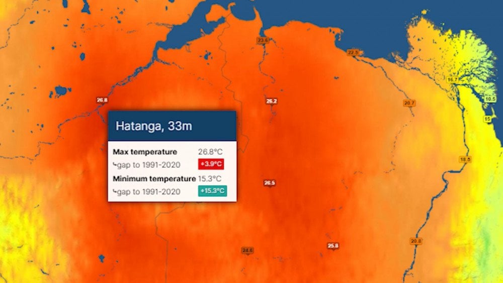
Record heat recorded in the village of Khatanga, Krasnoyarsk Krai, Russia
These were not the only temperature anomalies in Siberia.
Heat records in the city of Norilsk: August 8 Tmax = +26.5 °C (79.7 °F), August 9 Tmax = +27.2 °C (81.0 °F), August 10 Tmax = +27.1 °C (80.8 °F), August 15 Tmax = +24.5 °C (76.1 °F).
And in the Novaya Zemlya archipelago on August 9, thermometers rose to +25.4 °C (77.7 °F). At the polar station Malye Karmakuly, Arkhangelsk Region, daily heat records were broken for 6 consecutive days: August 8 Tmax = +21.9 °C (71.4 °F), August 9 Tmax = +25.4 °C (77.7 °F), August 10 Tmax = +23.6 °C (74.5 °F), August 11 Tmax = +22.6 °C (72.7 °F), August 12 Tmax = +21.5 °C (70.7 °F), August 13 Tmax = +19.3 °C (66.7 °F).
In southern Western Siberia, the picture was the opposite — temperatures remained below normal by almost 5 °C (9 °F). For example, in Kemerovo on the same day it was only +17.7 °C (63.9 °F).
Such “inverted” temperature contrasts are becoming increasingly frequent and anomalous.
Mexico
On the night of August 15, the south of Guadalajara, Jalisco State, became the epicenter of a natural disaster. First, a short but incredibly powerful hailstorm struck the municipality of Tlaquepaque, which in just 15 minutes paralyzed city life. The hail was so intense that in some places its layer reached one meter (3.3 ft), completely covering streets and parked cars.

A massive layer of hail covered the streets of Guadalajara, Jalisco State, Mexico
Major transportation routes instantly turned into impassable frozen rivers. Dozens of drivers were trapped, unable to move, and many were forced to abandon their damaged vehicles — windshields shattered, bodies dented.
The situation was catastrophically worsened by a downpour: in the municipality of Zapopan, the water level on the overpass across the Nogales Highway rose to 2 m (6.6 ft), collapsing structures and paralyzing traffic. And on the Tototlán — Zapotlanejo highway, a landslide occurred. In the residential areas of Lomas del Tapatío and Santa María Tequepexpan, water rushed into homes. Piles of hail blocked front doors, making it impossible to get outside.
Local businesses suffered massive losses from damaged goods and forced shutdowns. Meanwhile, children were outside building snowmen.
Australia
On August 16 at 9:49 LT in the settlement of Kilkivan, Queensland, the strongest inland earthquake in the region’s last 50 years occurred. It had a magnitude of 5.6. The hypocenter lay at a depth of 10 km (6.2 mi).
The tremors were felt hundreds of kilometers from the epicenter: from the city of Cairns, Queensland, to the city of Wollongong, New South Wales.
This event was shocking for the residents of Queensland, where strong earthquakes are so rare that many people did not immediately realize what was happening.
No serious destruction was recorded, but there were reports of small cracks in houses.
About 13,000 properties and three hospitals were left without electricity after sensors automatically shut down parts of the grid.
The railway company Queensland Rail reduced train speeds to check the condition of the tracks.
Typhoon Podul
On August 13, Typhoon Podul, named Yangliu by the Chinese Meteorological Observatory, made landfall on the coast of Taiwan Island in Taitung County with wind speeds exceeding 190 km/h (118 mph).
The strongest gusts of wind caused an aviation incident: a cargo Boeing flying from Hong Kong to Taipei struck the runway during landing and sustained fuselage damage.
The typhoon brought torrential rains to the island: within 24 hours in the south, Pingtung County received 440 mm (17.3 in) of rainfall, and in the mountains — up to 700 mm (27.6 in).
Water rose rapidly, flooding farmland and triggering floods and landslides. At least 7,000 people were evacuated, schools, offices, and enterprises closed. The power system could not withstand the impact: nearly 300,000 homes were left without electricity.
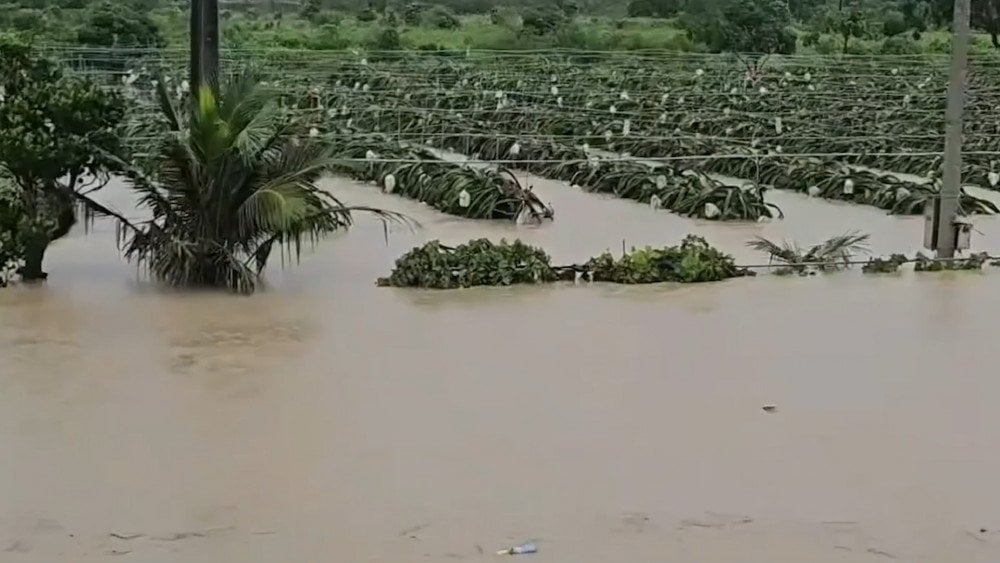
Torrential rains caused by Typhoon Podul flooded farmland on Taiwan Island
Taiwan Island was temporarily cut off from the outside world: 252 domestic and 129 international flights were canceled, and dozens of maritime routes were suspended.
As of August 15, one man swept away by waves while fishing was reported missing, and another 143 people were injured.
On the night of August 14, Podul, already downgraded to a severe tropical storm, struck the coast of Fujian Province in China and moved inland. Despite weakening, it brought powerful downpours to the southeast of the country. In Beihai County, Guangxi Province, nearly 300 mm (11.8 in) of rainfall was recorded. In Guangdong Province, more than 106,000 people were evacuated, tourist sites were closed, ferry lines suspended, and 150 trains rerouted.

Flooded city streets after Typhoon Podul, China
What set Typhoon Podul apart was the speed of its movement over land: it raced along at up to 45 km/h (about 28 mph), compared to an average of around 20 km/h (12 mph).
Spain
The forest fire in the municipality of Molesuelas de la Carballeda, Zamora Province, which began on August 10, became the largest in the country since the beginning of official records in 1968.
By August 15, 36,500 ha (90,208 acres) had burned.
The flames destroyed vehicles and homes, though the exact number has yet to be determined. About 7,800 people were forced to evacuate.
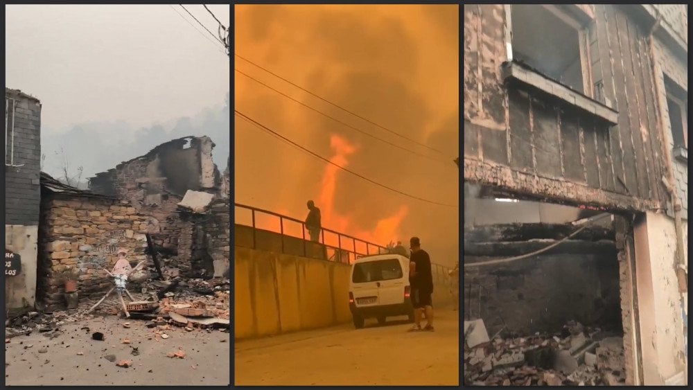
Catastrophic aftermath of forest fires in the municipality of Molesuelas de la Carballeda, Zamora Province, Spain
The fire disabled power lines, irrigation systems, and agricultural machinery. 11,000 ha (27,182 acres) of fields, olive groves, and vineyards turned into ashes.
In the affected region, the fire brought transportation to a standstill: 14 roads were closed, and high-speed train service between Madrid and Galicia was suspended.
Abejera in Zamora Province was literally turned into a “ghost town” by the fire.
More than 1,300 people and hundreds of vehicles were involved in fighting the disaster.
Unfortunately, the disaster claimed the lives of three people. At least six others sustained serious injuries, including burns and smoke poisoning.
The hot and dry summer in the country once again created the so-called rule of thirty — when the temperature exceeds 30 °C (86 °F), humidity is below 30%, and wind speed is above 30 km/h (19 mph). Under such conditions, even small ignition points instantly grow into uncontrollable fires.
As a result, the area burned by fire in Spain is already more than 4 times the average value.
According to the European Forest Fire Information System (EFFIS), in 2025, 348,238 ha (860,483 acres) have already burned, compared to the 2006–2024 average of 79,570.11 ha (196,584 acres).
Portugal
Over the past week, Portugal experienced one of the most critical moments of the current wildfire season.
As of August 19, 70 fires were raging in the country. More than 3,900 specialists and 1,300 units of equipment were involved in extinguishing them. Due to the scale and speed of fire spread, the army was also deployed.
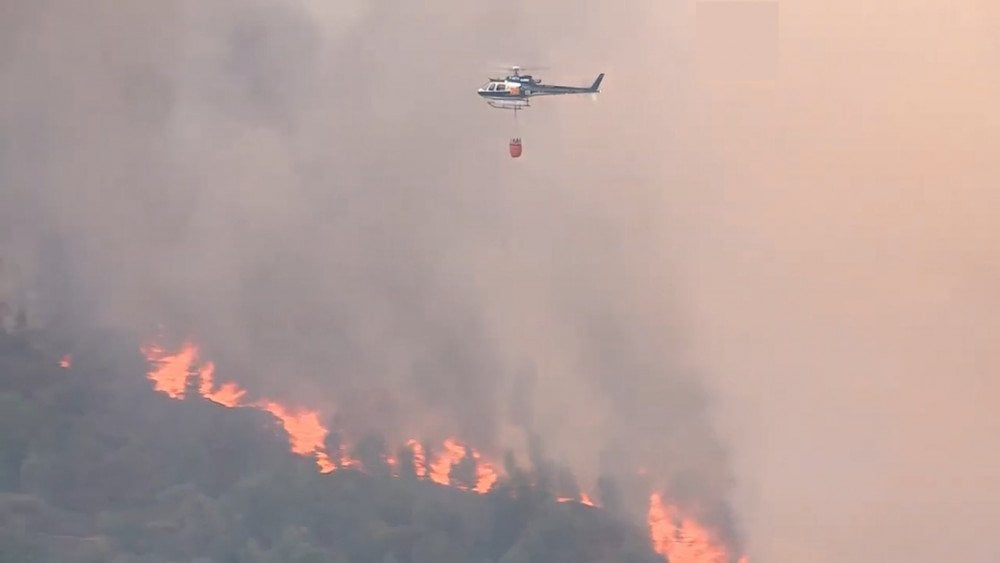
Extinguishing wildfire hotspots by helicopter in Portugal
As a result of the fires, three people have died.
Unless a person actively follows extreme weather and disaster reports, they often don’t even know what’s happening in a neighboring country. All they see is what’s outside their own window: “Well, maybe it’s a little worse than last year, or worse compared to two years ago.”
Meanwhile, various information sources insist that what we’re experiencing is “normal.” But the definition of “normal” shifts over time — which makes unusual events stop looking like anomalies. People start to see them as part of a natural cycle and feel reassured.
Take wildfires as an example. The average annual burned area and number of fires are usually compared against a “10–20 year average.” But here’s the catch: that’s not a fixed baseline that clearly shows how much worse the situation is getting.
Since this period is updated every year, the baseline includes abnormally high values of recent years — which in turn “raise the bar” of the average value, and the difference no longer looks as significant. This is how a simple mechanism of smoothing the picture of escalating cataclysms works.
Let’s look at an example. According to the European Forest Fire Information System (EFFIS), the average wildfire area in the EU for the ten-year period from 2006 to 2015 was 256,702 ha (634,235 acres). The territory burned by fire in the current year, from January 1 to August 19, is 1,015,024 ha (2,508,096 acres), which is almost 4 times larger.
But the current average value from 2006 to 2024, 354,628 ha (876,004 acres), already includes the extreme figures of recent years, when fires were rapidly increasing.
And with a similar comparison of this average value, 354,628 ha (876,004 acres), with the figure from January 1 to August 19, 2025, 1,015,024 ha (2,508,096 acres), we get a difference of 2.9 times.
Through simple math manipulations, the deviation from the norm has decreased by 100,000 ha (247,105 acres).
Formally, there is no direct falsification of data here: all the numbers are correct. But because very few people really look into this, everything appears to be “within the norm.”
And behind this are burned forests, dead animals, destroyed homes, and, most importantly, lost human lives.
The same can be observed with data on other natural events: floods, temperatures, tornadoes, earthquakes.
We wanted to show, through these examples, how the reality of climate change gets softened in public perception.
That is why it is so important to look into what is happening yourself. Once people start to see the true picture, they realize that disasters are spreading worldwide at an alarming pace — and they can share that truth with others. Honest, reliable information is not just valuable; it’s essential for keeping a clear mind in the face of the climate crisis.
You can watch the video version of this article here:
Leave a comment