Summary of Climate Disasters on the Planet, February 9–15, 2026
In the United States, a 130 km (80.8 miles) crack appeared in the ice of Lake Erie.
In Italy, a half-century storm repeated twice in three weeks.
In Argentina, snow suddenly fell in the middle of summer.
And in Germany, beneath the waters of a picturesque lake, magma is quietly but relentlessly making its way toward the surface.
Read more about these and other anomalous weather events from the past week, February 9–15, 2026, in the report below.
Storm Nils
On the night of February 12, Storm Nils struck France. According to data from Météo-France, a wind gust of 185 km/h (115 mph) was recorded in the commune of Cagnano, Corsica region — this speed became the highest for the region since 2009. Strong winds were also recorded in the Occitanie region: commune of Caixas — 180 km/h (112 mph), commune of Murat-sur-Vèbre — 168 km/h (104 mph).
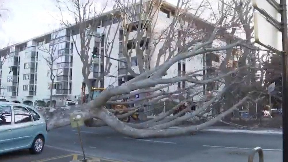
Trees toppled by strong winds during Storm Nils in France
Residents of the regions of Nouvelle-Aquitaine and Occitanie were affected the most. According to the electricity network operator Enedis, in the past 17 years there have been no natural phenomena of such magnitude here.
Floods, landslides, and fallen trees disrupted transport and supply systems. Up to 900,000 homes experienced power outages. In a number of cities, water supply was suspended.
In southern Corsica, the storm generated waves reaching about 8 m (26 ft) in height. At the airport, strong winds tore a 60 m² (646 sq ft) section of roofing from the terminal facade.
Across the affected regions, up to 150 mm (5.9 in) of precipitation fell in some areas within 72 hours. With soils already saturated, the additional rainfall caused many rivers—including the Garonne and its tributaries—to overflow their banks.
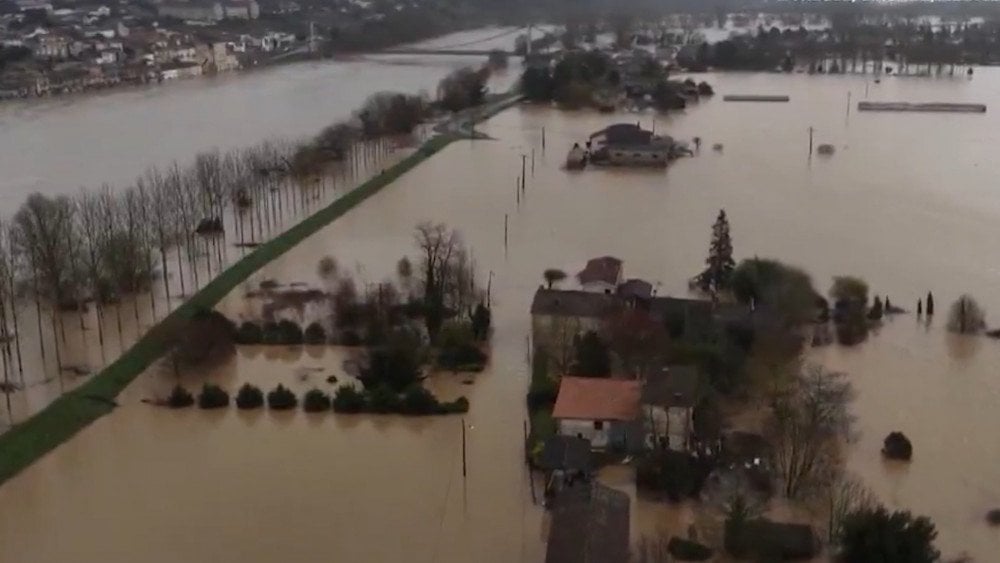
Heavy downpours during Storm Nils caused flooding in France
In the Charente department, Nouvelle-Aquitaine region, 66 residents of a nursing home located near the river were evacuated.
A section of the A9 motorway was temporarily closed after strong crosswinds overturned several trucks.
In the Alps, in the Haute Tarentaise and Mont Blanc regions, up to 100 cm (39 in) of snow fell within a short time. The snowfall accumulated on an unstable snowpack and triggered powerful avalanches.
Several ski resorts were closed.
It should be noted that in four departments of the country, a red danger level was activated for the first time for three parameters simultaneously: avalanche risk, strong wind gusts, and flooding.
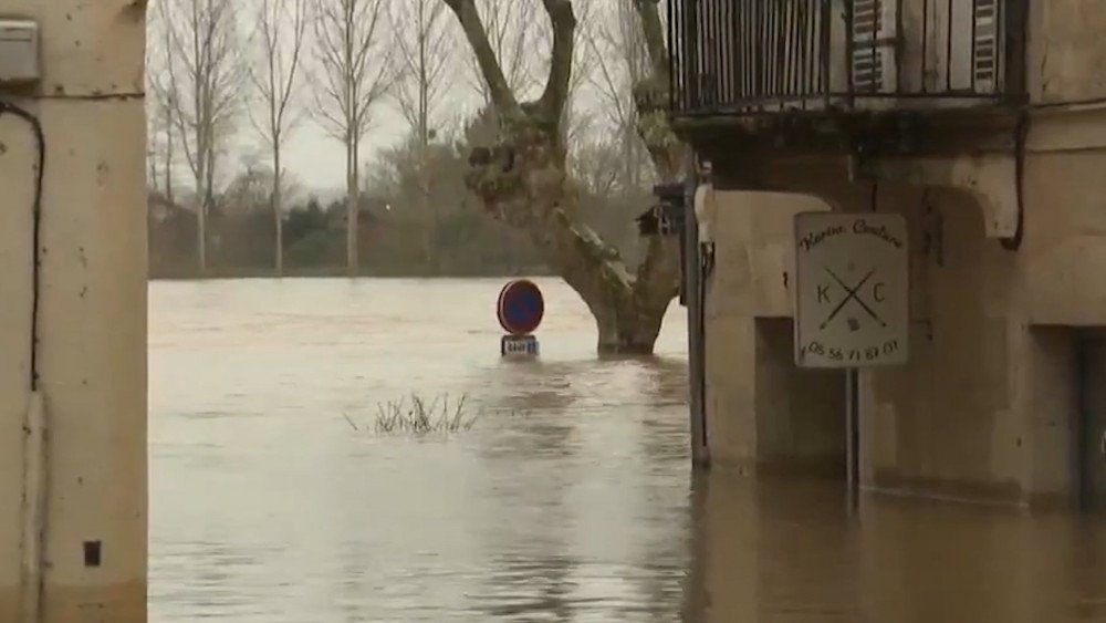
Storm Nils caused catastrophic flooding in France
In France, the storm claimed the lives of two people.
In Spain, Nils became the eighth storm since the beginning of the year. The highest alert level was declared in the autonomous communities of Galicia, Cantabria, and the Basque Country.
Catalonia was hit by the strongest winds in 20 years: transport connections were disrupted, businesses and institutions were closed, and all non-urgent medical appointments were postponed.

Wind gusts tore the roof off a building in the city of Barcelona, Catalonia autonomous community, Spain
In the city of Alicante, carnival events and Saturday markets were canceled. Football matches of the Valencian Federation were also called off.
At least 25 people were injured in the country as a result of the storm; five were hospitalized, one with severe injuries.
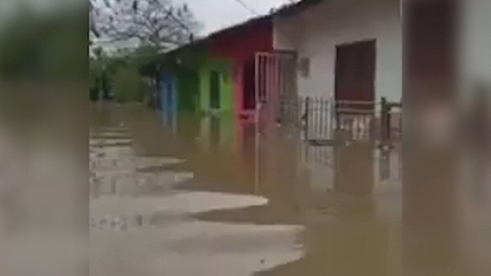
Colombia
On February 11, a powerful downpour with hail struck the country’s capital, Bogotá.
The northern districts of the city were hit the hardest: in the Usaquén district, 75 mm (3 in) of precipitation fell in 67 minutes — nearly 70% of the monthly norm, which is 50 mm (2 in).
As a result, basements and underground garages were flooded, and commercial properties were damaged — water penetrated inside the buildings. In one educational institution, the roof collapsed.
A powerful downpour flooded the streets of Bogotá, Colombia
The capital’s largest sports complex, El Campín, was also affected. To protect the stadium lawn from damage, it had to be covered with protective material.
A transport collapse occurred on major highways: cars became stuck in water and icy slush.
Such precipitation at this time of year is anomalous for Bogotá: January and February are usually dry months.
It should be noted that since January 26, torrential rains that triggered large-scale floods and landslides have already affected 16 departments of Colombia.
As of February 14, the disaster had claimed the lives of at least 17 people.
Large-scale floods and landslides caused serious destruction: more than 22,000 homes were damaged, of which 4,000 were completely destroyed.
A state of emergency was declared in the country.
Indonesia
On February 12, strong winds with heavy rain struck the city of Cibinong in Bogor Regency, West Java Province, Indonesia.
The storm raged for only about 15 minutes, but caused significant damage. The sports complex, the pride of the Bogor district residents, was particularly hard hit. People panicked and rushed to take cover from the flying debris of the stadium roof. One person was injured.
The sudden squall also tore roofs off more than 70 houses. Wind gusts knocked down trees, blew away market stalls, and overturned motorcycles.
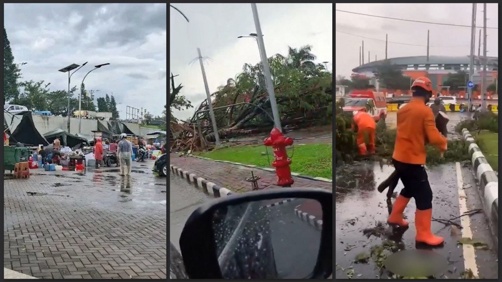
Squall winds knocked down trees and blew away market stalls in the city of Cibinong, Bogor Regency, West Java Province, Indonesia
The storm severely reduced visibility, forcing drivers to stop their vehicles to avoid collisions with trees and construction debris flying onto the road.
Argentina
On February 10, snow fell in the middle of summer in Argentine Patagonia. After several weeks of 30 °C (86 °F) heat, a cold front from the Pacific Ocean carrying polar air swept into the region.
The sharp drop in temperature led to heavy snowfall in the highlands.
Fresh snow covered the famous peak Cerro Catedral near the city of San Carlos de Bariloche, as well as Mounts Piltriquitrón and Perito Moreno in the vicinity of the city of El Bolsón.
At an altitude of over 1,600 meters, the temperature dropped to −4 °C (24.8 °F).
In addition to changing the landscape, the severe weather made National Route 40 between the cities of San Carlos de Bariloche and El Bolsón dangerous for travel.

A sharp cold snap after prolonged 30-degree heat led to heavy snowfall in Patagonia, Argentina
Despite the fact that snow and rain brought temporary relief to the region, which had previously suffered from severe drought and large-scale wildfires, this became yet another weather anomaly that indicates extreme instability and chaos in the atmosphere.
USA
Last week, North America experienced a powerful climate attack. The collapse of the polar vortex allowed Arctic air to advance into the northeastern United States, causing extreme frosts and unusual weather phenomena. The cold covered a vast region — from the Great Lakes to the Atlantic coast — affecting the states of New York, Pennsylvania, Massachusetts, Connecticut, and Rhode Island.
The Great Lakes almost completely froze over, which is a rare occurrence even during severe winters, when ice usually covers only certain areas. Lake Erie looked especially striking: its ice cover reached almost 96% of the surface, something not seen since 1996. Against the backdrop of severe frost and gusty winds, the ice could not withstand the stress, and on February 8 a giant crack about 130 km (80.8 miles) long formed in it, stretching from the Canadian shore to the city of Cleveland (Ohio, USA) and clearly visible in satellite images.
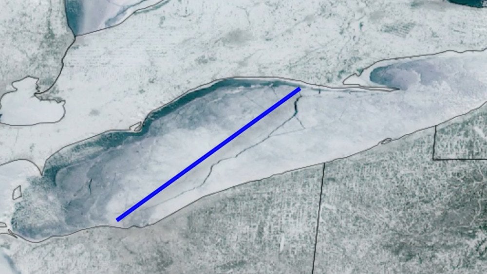
A crack about 130 km (80.8 miles) long formed on the frozen Lake Erie, Ohio, USA
The peak of the cold occurred on February 9–10.
In New York, the perceived temperature dropped to −26 °C (−14.8 °F), making being outdoors dangerous — frostbite could occur within minutes. Additional warming centers were opened in the city, and street patrols were intensified.
Sidewalks and roads became covered with ice, creating hazards for pedestrians and drivers. Public transportation operated with disruptions. Flight delays and cancellations occurred.
Utility services worked in an intensified mode to restore electricity supply and eliminate accidents caused by frost and icing.
In New York State, amid persistent cold, a record-high “ice volcano” formed in Letchworth State Park.

A giant ice “volcano” formed from the freezing water of a fountain in Letchworth State Park, New York, USA
Water from the fountain was thrown outward under pressure and instantly froze, forming an ice cone. On February 10, its height reached 9 m (29.5 ft).
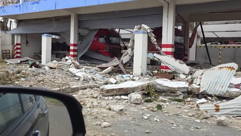
Tropical Cyclone Gezani
On February 10, the intense Tropical Cyclone Gezani made landfall near Toamasina, the second-largest city of Madagascar. Eyewitnesses described what was happening as “a noise similar to the continuous roar of a jet engine.”
Winds reaching up to 250 km/h (155 mph) tore off roofs, uprooted trees, and ripped apart power lines. In some districts of Toamasina, according to local authorities, up to 75% of buildings were destroyed.
A nationwide state of emergency was declared in the country.
The destruction proved catastrophic: communication lines, as well as power and water supply systems, were damaged. Roads were blocked by fallen trees and structural debris.
Tropical Cyclone Gezani left severe destruction in the city of Toamasina, Madagascar
According to the National Office for Risk and Disaster Management (BNGRC), as of February 13, at least 18,797 homes were completely destroyed, and another 37,430 were partially damaged.
Educational infrastructure was also severely affected: hundreds of classrooms were left without roofs.
In addition to hurricane-force winds, the cyclone brought powerful torrential rains. In low-lying areas, water quickly flooded 14,330 homes and schools.
In total, the disaster affected nearly 270,000 residents of the country, of whom more than 16,000 were forced to leave their homes. Some people were placed in temporary centers, while others found shelter with relatives.
Cyclone Gezani claimed the lives of 41 people across the country, and hundreds more were injured.
Aftermath of Tropical Cyclone Gezani in Madagascar: tens of thousands of homes destroyed
Continuing its movement, the cyclone struck the coastal province of Inhambane in Mozambique.
Winds with gusts up to 215 km/h (134 mph) knocked down trees and power line poles, leaving more than 13,000 people without electricity. In several districts of the city of Inhambane, water supply was disrupted.
At least four people died in Mozambique as a result of Cyclone Gezani.
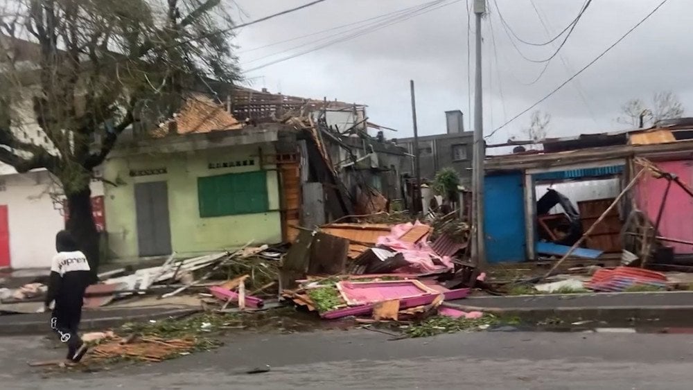
Italy
On February 12, a storm named “Harry Bis” struck Italy. Like the January storm Harry, it hit the regions of Sardinia, Sicily, and Calabria, bringing destructive winds and strong storm surges. Waves up to 9 m (29.5 ft) high were recorded in the open sea.
On the island of Sardinia, in the town of Villasimius, the wind tore the roof off a school building: debris struck the windows, which greatly frightened the students.
In the port of Porto Torres, wind gusts exceeding 100 km/h (62 mph) and rough seas caused the stern mooring line of a ferry to snap, after which it broke free from its anchor.
According to Lorenzo Tedici, meteorologist and media manager of the Italian weather forecast portal iLMeteo.it, an extreme storm like Harry occurs once every 50 years; however, a new cyclone of similar strength struck Italy just 21 days later.

Powerful wind tore the roof off a residential building in the city of Palermo, Sicily region, Italy
Seismic and Volcanic Activity
Last week, a series of strong earthquakes once again struck the planet. Casualties were avoided, but due to the anomalous frequency of underground tremors, residents of seismically active regions remain in constant anxiety.
On February 10 at 20:45 UTC, a deep-focus earthquake of M6.2 occurred near the Fiji Islands. The focus lay at a depth of 510.9 km (317.5 miles), so the tremors were not felt on the surface.
In the same region, on February 14 at 02:28 UTC, an earthquake of M6.4 occurred off the coast of Vanuatu, 53 km (33 miles) from the city of Port-Olry. The focus lay at a depth of 10 km (6.2 miles). Residents of the resort town of Port-Olry described the tremors as “very strong”: the shaking lasted about a minute. However, no destruction was reported.
On February 12 at 13:34 UTC, a seismic event of M6.1 was recorded in the Chilean region of Coquimbo, 32 km (20 miles) from the city of Ovalle. The focus lay at a depth of 54 km (33.5 miles). The epicenter was located in Bosques de Fray Jorge National Park. Tremors were felt from the Atacama region to Ñuble, as well as in neighboring Argentina.
The main consequences were landslides and rockfalls, in some places significant. In several communes, debris blocked local roads.
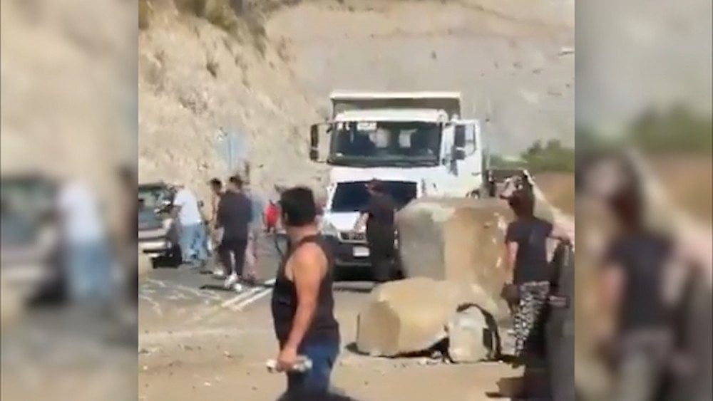
A rockfall triggered by the M6.1 earthquake blocked a road in Chile
On the night of February 10, at 23:21 UTC, in Russia, in the south of Krasnodar Krai, 13 km (8 miles) from the city of Anapa, an earthquake of M4.8 occurred. The focus lay at a depth of 10 km (6.2 miles). For this region, a seismic event of such strength is very rare.
Residents of the cities of Anapa and Novorossiysk woke up from the tremors. Videos quickly spread on social media: swinging chandeliers, shaking windows, and a growing rumble. The earthquake was also felt in neighboring regions.
Serious destruction was avoided; however, cracks appeared in some buildings in Anapa.
Two more seismic events of M6.0 were recorded in the Far Eastern Federal District: on February 11 at 06:29 UTC — in the Sea of Okhotsk, off the coast of Khabarovsk Krai, 229 km (142 miles) from the settlement of Okhotsk (the focus lay at a depth of 30 km / 18.6 miles); on February 15 at 15:59 UTC — 284 km (176 miles) from Severo-Kurilsk in Sakhalin Region, east of Matua Island (the focus lay at a depth of 73 km / 45.4 miles).
High seismic activity also continues in Kamchatka. Since July 30 last year, when the M8.8 mega-earthquake occurred, more than 35,000 tremors have already been registered. Even after nearly 7 months, the magnitudes of events remain extremely high, sometimes exceeding M6.0.
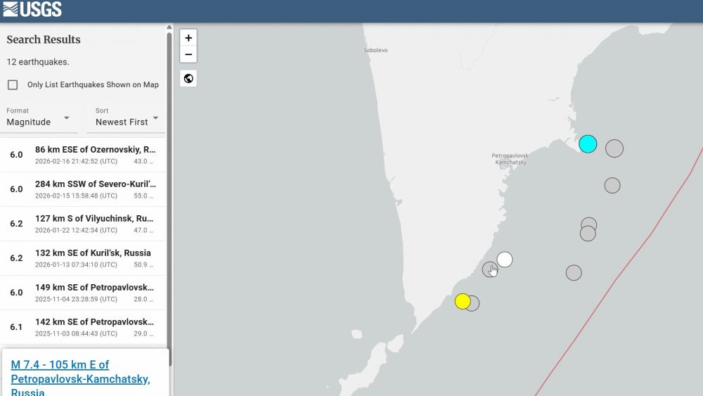
High seismic activity persists in Kamchatka after the M8.8 mega-earthquake, Russia
Kamchatka’s volcanoes are also active: at Shiveluch, regular ash emissions up to 11.6 km (7.2 miles) high have been recorded since February 5. Meanwhile, Krasheninnikov Volcano, which reactivated after nearly 500 years of silence, has been continuously emitting lava since August 2, 2025.
In recent years, a noticeable increase in seismic and volcanic activity has been observed — we have discussed the reasons for this repeatedly in previous reports. Erupting volcanoes cause many problems: they disrupt air travel, cover cities with ash, degrade air quality, and create a direct threat to people. But their behavior can usually be monitored and predicted. Much greater concern is caused by another category — hidden giants whose activity may remain unnoticed for a long time, yet a single powerful eruption can destroy life across vast territories. These are supervolcanoes.
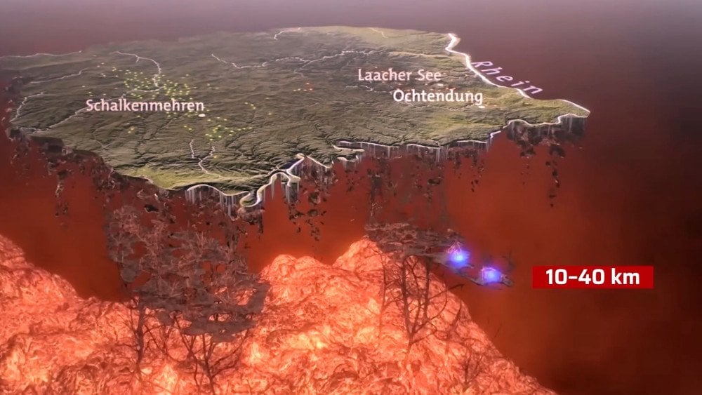
One of the most dangerous volcanoes in Europe lies hidden in western Germany — the Laacher See supervolcano. Its last eruption occurred about 13,000 years ago and had a VEI 6 index.
The Volcanic Explosivity Index (VEI) is a numerical scale that measures the relative explosive power of historical eruptions.
To determine the explosivity idex, scientists use the volume of erupted material, the height of the eruptive column, and qualitative observations (using terms from “gentle” to “mega-colossal”).
The largest volcanic eruptions in history (supereruptions) receive a value of 8. A value of 0 is assigned to non-explosive eruptions defined as ejecting less than 10,000 m³ (353,000 ft³) of tephra; a value of 8 corresponds to a mega-colossal explosive eruption capable of ejecting 1.0 × 10¹² m³ (3.53 × 10¹³ ft³) of tephra and forming an eruptive column more than 20 km (12.4 miles) high.
During the Laacher See eruption, about 6.5 km³ (1.56 cubic miles) of magma was expelled over several days.
Today the volcano appears completely calm, yet observations from recent years indicate continuing and increasing magmatic activity beneath it: elevated emissions of magmatic CO₂ are being recorded, and the Earth’s surface is gradually rising by several millimeters per year.

One of the most dangerous volcanoes in Europe — Laacher See — shows signs of activity, Germany
According to research, since 2013 episodic deep low-frequency earthquakes have begun occurring beneath the Laacher See supervolcano, associated with the movement of magmatic fluids in the upper mantle and lower crust.
Deep low-frequency earthquakes are being recorded beneath the Laacher See supervolcano, Germany
From September 2022 to August 2023, specialists from the German Helmholtz Centre for Geosciences (GFZ), together with universities and seismic services from Germany and Luxembourg, conducted the largest seismological experiment in Germany’s history — Large-N. Nearly 500 seismic stations and 64 km (39.8 miles) of fiber-optic cable were deployed to collect data.
The study area was concentrated around the Laacher See volcano. Seismic stations were placed up to 2 km (1.24 miles) apart, allowing even earthquakes with magnitudes below 1.0 to be detected.
During the Large-N experiment, 1,043 microearthquakes were recorded. Most of them were concentrated along the narrow vertical Ochtendung seismic zone, at depths of 10–16 km (6–10 miles). These events occurred episodically, in “clusters” of 4–11 earthquakes lasting up to two days.
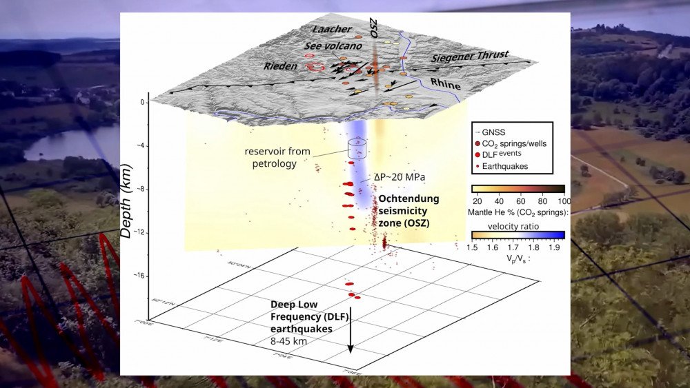
Large-N experiment data confirming magmatic activity beneath the Laacher See supervolcano, Germany
Using tomography, scientists identified a magmatic reservoir beneath Laacher See in the upper crust. It appears as a cylindrical anomaly extending to a depth of about 10 km (6.2 miles). Previous studies identified a channel transporting magma and fluids upward from the mantle; geochemical gas analyses also indicate that the reservoir beneath Laacher See is fed by mantle sources.
Since the beginning of 2023, a sharp increase in microseismic activity has been observed in the Eifel volcanic region, where the German supervolcano is located.
On October 10, 2025, an unusual earthquake sequence of 92 events was registered beneath the western slope of Laacher See. The strongest tremor, M0.9, occurred at a depth of 7 km (4.3 miles).
Although the earthquakes were too weak to be felt by residents, the event is considered exceptional. According to a volcano observer, this is the first case of its kind in his 25-year career.
Thus, the conducted studies and the latest anomalous seismic episodes indicate that the magmatic reservoir beneath the Laacher See supervolcano remains active and is likely under elevated pressure. Microearthquakes in the area suggest the ongoing accumulation of magma and fluids.
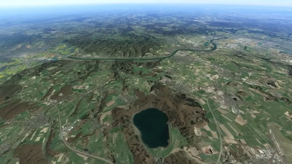
Aerial view of the Eifel volcanic region: Lake Laacher See, where signs of magmatic activity have been detected, Germany
In simple terms, even if you live on the shore of a beautiful calm lake — such as the Laacher See caldera — it does not mean that deep beneath it something serious and dangerous is not quietly preparing to awaken…
Watch the video version of this article here:
Leave a comment