Summary of climate disasters on the planet: April 30–May 6, 2025
The first days of May 2025 came as a shock to millions of people around the world. Natural disasters spared neither megacities nor rural areas. Hail, snow, tornadoes, sandstorms—all of this occurred within just one week, from April 30 to May 6, 2025.
What is happening with the weather, and what is humanity lacking to overcome the climate crisis?
France
On May 3, a hailstorm with heavy rain and strong winds hit France. In some areas, hailstones reached up to 4 cm (1.6 inches) in diameter. Although the storm lasted only a few minutes, it disrupted transportation in several parts of the Île-de-France region.

Large hail fell in France
In Paris's Montsouris Park, a wind gust of 90 km/h (56 mph) was recorded, along with a temperature drop from 27°C (80.6°F) to 15°C (59°F) in just a few minutes. Flooding left city streets strewn with debris, and several metro stations—Alma-Marceau, Voltaire, Porte de Champerret—were temporarily closed.
The storm led to numerous delays and cancellations at Paris Charles de Gaulle International Airport.
This powerful storm was triggered by abnormally hot weather observed in the days prior. On May 1, the maximum temperature reached +29.4°C (84.9°F), and on May 2— +28.7°C (83.7°F), significantly above the seasonal norm (average max = +20.2°C / 68.4°F).
Although meteorologists had issued warnings about adverse weather conditions, the actual scale of the storm came as a surprise. Parisians, accustomed to spring showers, were unprepared for such a powerful force of nature.
One local resident said: “If you think you're safe in the city, just fifteen minutes is enough to turn everything upside down.”
Russia
An abnormally intense May snowstorm struck Central Russia.
The regions affected by the weather disaster included Moscow, Yaroslavl, Tver, Nizhny Novgorod, Vladimir, and Ivanovo Oblasts.
The Moscow Region was hit particularly hard. On May 1, Moscow recorded 27.6 mm (1.09 inches) of precipitation, breaking a 116-year daily record. The previous record was 20.6 mm (0.81 inches) set in 1909.
By the night of May 2, up to 20 cm (7.9 inches) of snow had fallen.
Unable to withstand the weight of the wet snow, fully leafed-out trees began to fall en masse—more than 2,500 trees were toppled.
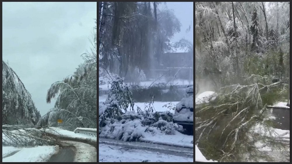
May snowfall in Russia: broken and fallen trees after winter’s unexpected return
Fallen trees blocked railway lines, causing multi-hour delays for 60 commuter trains and several long-distance trains. Nearly 200 cars were damaged, 237 power lines and 4,400 transformer substations were knocked out.
More than 800 towns and villages were left without electricity. Restoration efforts were complicated not only by the need to fix broken lines but also by the necessity to build new power lines.
In some areas, people spent more than 4 days without heat, water, or communication, cooking over open fires and warming themselves in their cars.
On May 6 in the Altai Republic, a tornado—rare for the region—occurred. Residents were shocked as a funnel began forming right above the rooftops of their homes in the village of Iogach, Turochaksky District.

The tornado left a trail of destruction in Iogach village, Turochaksky District, Altai Republic, Russia
The tornado then moved into the forest, mowing down hundreds of trees.
India
On the morning of May 2, the Delhi Capital Region was struck by a fierce and unexpected storm, accompanied by winds reaching up to 80 km/h (50 mph) and torrential rain. It brought chaos, destruction, and human casualties.
In the town of Najafgarh, an uprooted tree fell onto a house, claiming the lives of a woman and her three children. Another person was electrocuted while trying to take shelter from the rain.
The intensity of the downpour was unprecedented: on May 2 alone, Delhi received 77 mm (3.03 inches) of rain—more than triple the monthly average of 24.7 mm (0.97 inches) for May.
The storm’s rampage caused major disruptions to transportation. About 200 flights were delayed at Delhi Airport, and trees that fell onto railway tracks disrupted train operations. Many streets across the metropolis were flooded.
The scale and suddenness of the storm took both residents and the country’s meteorologists by surprise. According to them, while there was a forecast for possible rain, no one anticipated a storm of such intensity. Moreover, thunderstorms of this strength are extremely rare in northern India at this time of year.

During a severe storm in India, a tree fell on a car and damaged it
The warning about the approaching storm was issued at 2:30 AM, when most people were still asleep and didn’t see it.
India Meteorological Department explained the powerful and unexpected storm as the result of an extremely rare combination of meteorological factors for the region—simultaneous inflows of moisture from both the Arabian Sea and the Bay of Bengal.
Afghanistan
On May 2, torrential rains triggered flash floods and landslides in Afghanistan’s Badakhshan Province. The hardest-hit areas were Baharak and Jurm districts.
The disaster destroyed around 170 homes, damaged roads and the water supply system, leaving residents without access to drinking water. Powerful floodwaters swept away vehicles and wiped out more than 800 hectares (1,976 acres) of farmland and orchards. Approximately 300 livestock perished.

Aftermath of flash flooding in Badakhshan Province, Afghanistan
According to a local resident, “People were left with nothing but the clothes they had on them.”
The flood blocked the road connecting the provincial capital, Fayzabad, to Baharak District.
In Jurm District, at least two people were killed and three others injured.
USA
Throughout the week, the United States remained under the grip of destructive storms.
On April 30, powerful thunderstorms swept across a dozen states, from Texas to New York. In Oklahoma, the storm forced road closures. Torrential rains triggered flash floods.
In the town of Wewoka, river and creek levels rose to the height of bridges, and raging waters uprooted large oak trees. Flooding of this magnitude hadn't been seen there in many years.

Heavy rains caused flooding in the state of Missouri, USA
Evacuations were declared in several parts of the city of Lawton. In Pottawatomie County and Lincoln County, Oklahoma, floods claimed the lives of two people.
In the state capital, Oklahoma City, April became the wettest month on record—since the start of the month, over 300 mm (11.8 inches) of rain fell, compared to the usual 100 mm (3.9 inches).
The storm also disrupted air travel. At Dallas Fort Worth International Airport in Texas alone, hundreds of flights were canceled.
On May 2, winds exceeding 100 km/h (62 mph) and hail up to 6 cm (2.4 inches) in diameter caused damage in Mississippi, Alabama, Tennessee, and Kentucky. By the morning of May 2, more than 350 storm warnings had been issued, including 12 tornadoes and 38 flash flood alerts.
In Georgia, four people were injured when part of a building's roof collapsed. In Louisiana, near New Orleans, a tornado passed through residential areas.
On May 5, a tragedy occurred in Brenham, Texas: a 10-year-old girl was swept away by floodwaters while returning home from school. Unfortunately, she could not be saved. In the city of Colleyville, lightning struck a residential house, causing a fire that injured three people.
On May 6, large hail fell in parts of Texas and Louisiana, with some hailstones reaching up to 8 cm (3.1 inches).
In rural northern Texas, strong winds damaged wind turbines and a nearby airport.
Meteorologists explained the prolonged and destructive storm activity as the result of a rare atmospheric phenomenon—a high-pressure area trapped between two low-pressure systems. This type of atmospheric blocking is known as an Omega block because it resembles the Greek letter Ω on pressure maps. It prevents weather systems from moving, resulting in extended storms.

Flooded gas station after torrential rains, state of Tennessee, USA
Although such atmospheric traps are not uncommon in spring, events of this strength in early May are considered extremely rare and dangerous by meteorologists.
Mexico
The same wave of severe weather also affected neighboring Mexico. On the evening of May 1, the state of Nuevo León was hit by a destructive downpour accompanied by abnormally large hail.
The hardest-hit areas were the municipalities of Ciénega de Flores and Salinas Victoria.
In Ciénega de Flores, hailstones reached up to 7 cm (2.8 inches) in diameter. Dozens of cars were damaged, and house roofs were punctured.

Large hail in Mexico caused significant damage
Many residents were left with shattered windows and unexpected expenses—insurance companies do not always cover hail-related damage. Such an event is rare for the region, which typically sees less intense precipitation.
Middle East
A rare and large-scale meteorological event was recorded on April 30 — an extensive dust storm swept across nine Middle Eastern countries at once: Palestine, Jordan, Egypt, Syria, Lebanon, Iraq, Kuwait, Qatar, and Saudi Arabia.
Scorching air from the south raised temperatures by 8–12°C (14.4–21.6°F) above normal, and wind gusts reaching up to 70 km/h (43.5 mph) lifted massive clouds of dust. This led to transportation disruptions and posed serious health risks.
On May 4, the same storm system triggered hazardous weather in Jordan: rain, thunderstorms, and dust reduced visibility and caused flash floods in low-lying areas. In Petra—one of the country's main tourist attractions—heavy rains flooded parts of the archaeological complex, prompting authorities to evacuate more than 1,700 visitors. In the Shoubak area, a woman and her son—tourists from Belgium—died due to the flooding.

Heavy rains flooded the archaeological zone of Petra—a popular tourist destination in Jordan
That same day, Kuwait was hit by strong winds and a dense dust storm, temporarily halting operations at airports and seaports. Wind gusts exceeding 100 km/h (62 mph) reduced visibility in some areas to zero.
On May 5, a powerful sandstorm struck Baghdad and surrounding areas, blanketing the Iraqi capital in a thick layer of dust and debris. Visibility in the city plummeted—in some areas to just 1 km (0.62 miles).
In central Saudi Arabia, in the Ar Rass area of Al-Qassim Province, a rare natural phenomenon known as a “dust wall” was observed—a dense curtain of dust that completely obscures the horizon.
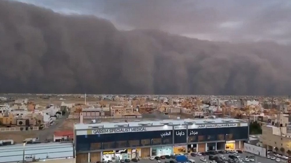
A massive ‘dust wall’ obscured the horizon in the Ar Rass area, Al-Qassim Province, Saudi Arabia
According to experts, it was formed by a microburst—a powerful downdraft hitting the ground and lifting large amounts of dust and sand into the air. In some cases, the height of the dust wall can exceed 2 km (1.24 miles).
China
During the May holidays, China was swept by a wave of extremely severe convective storms.
On May 3, a powerful sandstorm struck the tourist-packed city of Dunhuang in Gansu Province. In the Yadan National Geological Park, wind speeds exceeded 32 m/s (115 km/h or 71 mph), which corresponds to Force 12 on the extended Beaufort scale.

A powerful sandstorm caused a sharp drop in visibility and disrupted tourism in Dunhuang, Gansu Province, China
Visibility dropped below 500 m (1,640 ft). As a result, around 10,000 tourists were stranded in the scenic areas of Yangguan and Yumenguan.
It’s worth noting that Dunhuang is surrounded by numerous deserts, so sandstorms in the city are not uncommon. However, locals reported that this time, the event was far more intense than usual.
In Sichuan Province, the storm raged through the night of May 4 to 5. In the Yangtze River Basin alone, over 30,000 lightning strikes were recorded during the night. In Qionglai County, Chengdu City, wind speeds reached up to 28 m/s (101 km/h or 63 mph) in places.
Many eyewitnesses on social media described how “insane” the wind was. Canopies, billboards, and electric scooters were blown over, belongings were swept away, and outdoor AC units were torn from walls.

Powerful winds struck Sichuan Province, China
On May 4 in Qianxi County, Guizhou Province, a tragedy occurred on the Yachi River near the Dongfeng Reservoir. Just 5–6 minutes after several cruise boats departed the dock, a sudden thunderstorm erupted with thunder, lightning, torrential rain, and hail. Wind speeds exceeded 41.5 m/s (149.4 km/h or 92.8 mph), which corresponds to Force 14 on the extended Beaufort scale.
As a result of the disaster, 4 boats capsized with a total of 84 people onboard.
According to official reports, 70 passengers sustained injuries of varying severity, and 10 people lost their lives.
It’s particularly important to note that an orange hail warning—indicating a high probability of hazardous weather—had been issued at 2:40 AM on May 4. Nevertheless, cruise operations in the tourist area continued unchanged.

Streets flooded with water and hail after a powerful storm in Guizhou Province, China
Climate disasters are becoming more sudden, unpredictable, and destructive. None of us are safe anymore.
Some people don’t see reality because they haven’t been affected yet. But in a short time, everyone will feel the consequences.
The good news is that more and more people around the world are beginning to see the truth and call things by their names. A person who stops deceiving themselves begins to think more deeply and ask questions: “How did we get here? Why were we silent? Why didn’t we act earlier?”
Of course, awareness doesn’t come to everyone at once. We’re different: some people need more time to grasp a simple truth, others understand faster. But unfortunately, the climate will help us all understand. The question is—will we have time to realize the scale of the threat and respond appropriately? Our future depends directly on this.
Humanity has a will to live and a desire to live better. But we are missing the most important thing—a common goal. Without it, our existence loses meaning. We fight without knowing what for—each person on their own.
If humanity finally finds that common goal—to survive, to preserve the planet, to protect one another—then we will be able to overcome the climate crisis. This is what we are lacking right now the most—unity and a common goal.
You can watch the video version of this article here:
Leave a comment