Summary of climate disasters on the planet, November 5-11, 2025
The collapse of a giant bridge in China.
A historic drought in Iran.
Destructive tornadoes in Brazil.
Two deadly typhoons in the Philippines.
And this is only part of the natural disasters that shook the planet over the past week, from November 5 to 11, 2025.
But there is one truly astonishing piece of news that gives hope for finding a way out of this climate nightmare.
Brazil
On November 7, storm winds with downpours, hail, and even tornadoes struck several states of Brazil. The states of Rio Grande do Sul, Santa Catarina, and Paraná were affected the most.
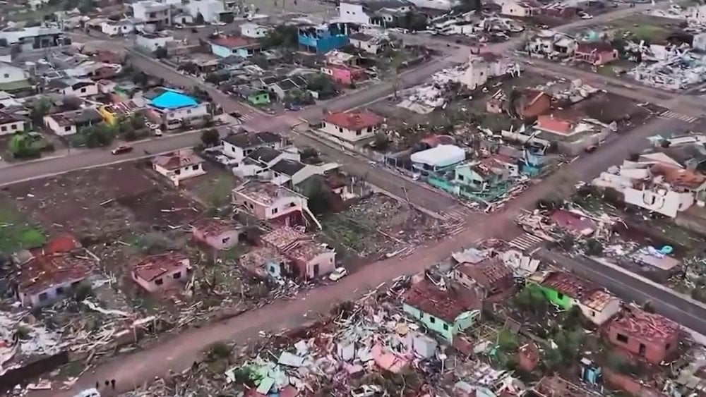
The most tragic event occurred in the state of Paraná, where 90% of the territory of the municipality of Rio Bonito do Iguaçu was destroyed by a powerful tornado. In just a few minutes, entire neighborhoods were reduced to ruins, and cars were scattered around like children’s toys.

Aftermath of the destructive tornado in the municipality of Rio Bonito do Iguaçu, Paraná State, Brazil
The town resembled a war zone. Rescue teams spent hours clearing the debris in search of survivors.
Tragically, the disaster claimed 6 lives: five people died in Rio Bonito do Iguaçu, and one person — in the municipality of Guarapuava.
750 people were injured, 30 of them severely. The injured were taken to hospitals in nearby towns. A field hospital was deployed to provide medical assistance to local residents.
At least 1,000 people were left homeless. Temporary shelters for evacuees were organized in neighboring settlements.
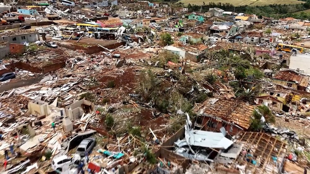
Catastrophic destruction after the EF-4 tornado in the municipality of Rio Bonito do Iguaçu, Paraná State, Brazil
The municipality was destroyed, but people did not lose hope: some helped their neighbors, others were simply grateful to be alive. Aid began arriving from nearby towns, and volunteers together with residents cleared streets and debris. One of the survivors said: “The wind took everything except the will to live.”
According to a study by MetSul Meteorologia, the destructive tornado that struck the city of Rio Bonito do Iguaçu became one of the most powerful on the planet this year and the most tragic in Brazil’s modern history.
A preliminary assessment by MetSul Meteorologia, based on the scale of destruction, indicates that the tornado in Rio Bonito do Iguaçu reached Category 4 on the Enhanced Fujita Scale (EF-4), which ranges from EF-0 to EF-5. This means that wind speeds reached 250–300 km/h (155–186 mph).
Brazil faced unprecedented destruction after the tornado
Field analysis and radar imagery confirmed that three more tornadoes formed in the neighboring state of Santa Catarina, where they caused significant damage to three municipalities: Dionísio Cerqueira, Xanxerê, and Faxinal dos Guedes.
The storm brought heavy rainfall to the central and northern parts of Rio Grande do Sul. In the municipality of Arvorezinha, 138 mm (5.43 inches) of rain fell, and in Anta Gorda the daily rainfall reached 152 mm (5.98 inches), exceeding the monthly norms.
In Porto Alegre, the state capital, wind gusts reaching 107 km/h (66 mph) toppled trees. One of them fell in the municipality of Rolante, killing a young man.

Powerful wind gusts toppled trees in Porto Alegre, Rio Grande do Sul State, Brazil
About 800,000 residents were left without electricity.
In the Serra Gaúcha region, numerous landslides caused road disruptions and damage to property. In the municipality of Caxias do Sul, a collapse damaged a residential building and four vehicles — fortunately, no one was injured.
In the state of Paraná, the destruction was so extensive that a state of emergency was declared in at least 14 cities.
New Zealand
On November 8, a large wildfire broke out in Tongariro National Park — a popular hiking destination whose landscapes were used in the filming of “The Lord of the Rings” trilogy.
Tongariro National Park — the country’s first national park, established in 1887 — covers an area of 80,000 ha (197,700 acres) and is a UNESCO natural and cultural heritage site.
Initially, the fire covered about 50 ha (124 acres), but it spread rapidly. According to eyewitnesses, the flames reached 30 m (98 ft) in height and stretched for nearly 4 km (2.5 miles), destroying subalpine vegetation in their path.
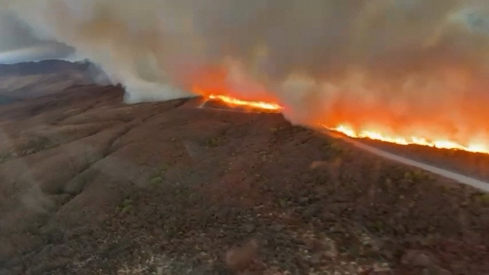
A large wildfire erupted in Tongariro National Park, New Zealand
Dozens of tourists had to be urgently evacuated by helicopter. According to visitors, shortly before rescuers arrived, the air was filled with smoke, and ash was falling from the sky.
Popular hiking trails, including the famous Tongariro Alpine Crossing, were completely closed, and some of the access roads leading to the park were blocked.
In addition to ground crews, five planes and 12 helicopters were deployed to extinguish the fire.
At night, operations had to be temporarily halted due to the difficult mountainous terrain and danger to firefighters. Two days later, thanks to the onset of torrential rains, the fire was finally contained.
The natural disaster destroyed about 2,800 ha (6,920 acres) of the park’s territory. Ecologists note that the recovery of the burned areas may take years, as the local alpine flora and fauna are extremely vulnerable to fire.
Canada
A rare early snowstorm struck southeastern Canada on November 9, covering the provinces of Quebec and Ontario.
In Quebec Province, up to 35 cm (13.8 inches) of snow fell overnight in some areas.
The Montérégie region and the city of Montreal were hit the hardest. Falling branches damaged power lines, leaving nearly 400,000 households without electricity. Roads became slippery, leading to serious accidents.
Public utility services had to clear about 10,000 km (6,214 miles) of streets and sidewalks.

A heavy snowfall struck Quebec Province, Canada
In the south of Ontario Province, the country’s largest city — Toronto — saw nearly 10 cm (3.9 inches) of snow, and Hamilton — up to 16 cm (6.3 inches) of snow. Such an early snowfall has not occurred here in more than 50 years. Usually, the first snow of this intensity falls only in December.
Ontario Provincial Police recorded hundreds of traffic accidents in 24 hours.
USA
A winter storm also struck the United States, bringing Arctic cold and heavy snowfall. In the Midwest and the Great Lakes region, up to 30 cm (11.8 inches) of snow fell on November 9–10. Around the city of Chicago, highways were buried in snow, completely halting traffic.

A snowstorm created dangerous road conditions and caused a truck to skid in Indiana, USA
Snowfalls swept across the states of Michigan, Indiana, Ohio, Pennsylvania, and New York — cold air from Canada collided with warm streams over the lakes, triggering powerful blizzards.
The cold wave rapidly moved south, and by the morning of November 11, more than 190 million Americans felt the chill.
Temperatures in Florida, Alabama, and Georgia dropped 10–14 °C (18–25 °F) below normal, reaching −3 °C (26.6 °F) in some places. In Jacksonville and Savannah, −2 °C (28.4 °F) was recorded — the coldest November morning in almost half a century.
Even in warm Miami, the air cooled to +9 °C (48 °F) — shocked residents watched frozen iguanas fall from trees.
Japan
In Japan, a sharp surge of seismic activity was observed in the Tōhoku region over the past week.
The main M6.9 earthquake occurred on November 9 at 17:03 LT off the Sanriku coast, in the Tōhoku region, 126 km (78 miles) east of Yamada. The hypocenter lay at a depth of 10 km (6.2 miles). Seismic tremors reaching 4 on the Richter scale were felt in the prefectures of Iwate and Miyagi. The disaster triggered a tsunami threat: in the ports of Kuji, Ōfunato, and Kamaishi, waves up to 20 cm (7.9 inches) were recorded.
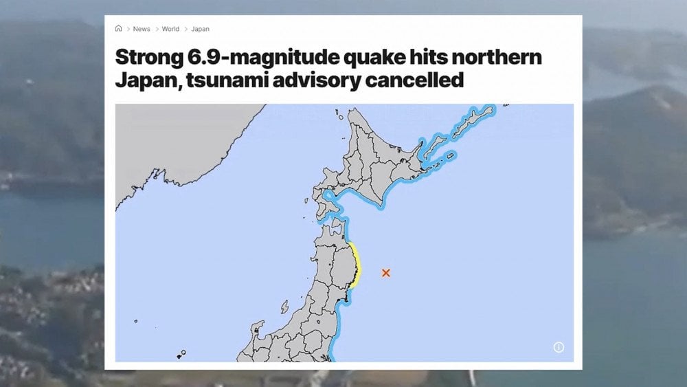
A powerful earthquake occurred in northern Japan, with an epicenter located in the ocean not far from the coast
Less than an hour later, at 17:54 LT, a second strong earthquake, M6.6, struck 121 km (75 miles) east of Yamada. The hypocenter was at a depth of 10 km (6.2 miles).
On November 10, the activity continued. In the second half of the day, at 16:23 LT, a new M6.4 tremor was recorded 120 km (75 miles) east of Yamada, felt by residents of five Tōhoku prefectures. The hypocenter lay at a depth of 11.2 km (6.96 miles).
In just a little over 24 hours, 37 earthquakes of M3.5 and above occurred in the Sanriku area, with 15 of them reaching M5.0 or higher.
Typhoon Kalmaegi
Residents of the Philippines had not yet recovered from the powerful M6.9 earthquake and a series of typhoons when nature struck again.
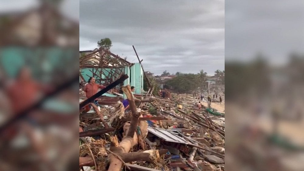
On November 4, Typhoon Kalmaegi struck Cebu Province, bringing torrential rains, landslides, and catastrophic flooding. In the Philippines, Typhoon Kalmaegi is known as Tino. The city of Toledo saw up to 428 mm (16.85 inches) of rain in 24 hours, which is 3 times above the monthly norm.
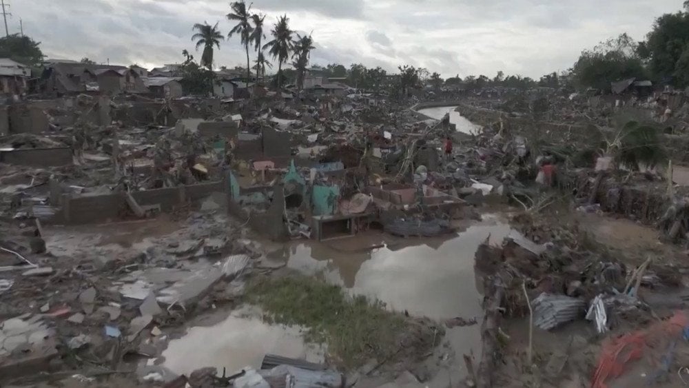
Aftermath of the catastrophic flooding caused by Typhoon Kalmaegi in the Philippines
According to the Philippine Atmospheric, Geophysical and Astronomical Services Administration (PAGASA), the Bagakay ARG station recorded 428 mm (16.85 inches) of rainfall in 24 hours, and the Ilihan ARG station — 300 mm (11.81 inches).
Most hydraulic structures in the region are designed for a maximum water level of 5 m (16.4 ft), and the strongest ones — up to 10 m (32.8 ft). But the typhoon brought 12 m (39.3 ft) — more than existing structures could withstand. As a result, water rushed from the mountains into residential areas. In some places, the water level rose above 3 m (9.8 ft), flooding entire neighborhoods. And some poor districts with fragile homes were completely washed away by the powerful flows.
Residents shared that they had lived through typhoons before, but Kalmaegi was different and too strong.

In the Philippines, people were forced to escape the flooding on the roofs of their homes
After the water receded, the scale of destruction became visible. People cleared away thick layers of mud and debris, trying to find at least something that could be salvaged.
A week after the disaster, many areas of Cebu still had no water supply: major pipelines and artesian wells were damaged, and reconstruction progressed slowly due to collapsed infrastructure.
Although Kalmaegi was not the strongest typhoon in terms of wind speeds, its slow movement and monstrous volume of water made it deadly.
According to authorities, most victims drowned. According to the Office of Civil Defense as of November 11, 232 people died in the Philippines, 112 were reported missing, and another 532 were injured.
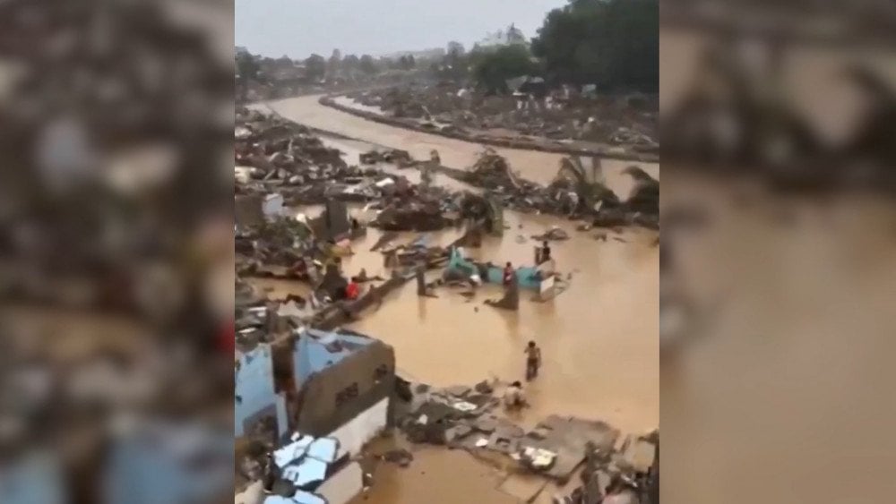
Torrential rains brought by Typhoon Kalmaegi flooded entire areas of Cebu Province in the Philippines
Typhoon Kalmaegi then continued toward Vietnam, which was also still recovering from destructive floods the previous week. On November 6, with wind speeds reaching 183 km/h (114 mph), the disaster struck Dak Lak and Gia Lai Provinces. In some areas, more than 350 mm (13.78 inches) of rain fell in just 6 hours. Strong winds toppled trees, destroyed walls of buildings, and millions of people experienced power outages.
The typhoon damaged almost 30,000 homes, 320 of which were completely destroyed.
Destruction after Typhoon Kalmaegi passed through Vietnam
In Gia Lai Province, more than 300,000 people were evacuated — the largest operation in the region’s history. According to authorities, such preventive measures helped avoid mass casualties; however, the disaster still claimed five lives, and three more people were reported missing.
Typhoon Fung-wong
On November 9, the Philippines once again came under the onslaught of nature. Super Typhoon Fung-wong struck Aurora Province on Luzon Island with wind speeds up to 185 km/h (115 mph) and gusts exceeding 230 km/h (143 mph).
Typhoon Fung-wong, known in the Philippines as Super Typhoon Uwan, left entire provinces without electricity.
More than 1,400,000 people from 12 regions were evacuated in advance. The aftermath of the disaster was devastating: the country’s agricultural sector alone suffered losses of about $2.4 million. Rice crops were the most severely affected.

The powerful strike of Super Typhoon Fung-wong caused large-scale destruction in Aurora Province, Luzon Island, Philippines
Over 130 villages were flooded, and residents caught by the sudden rise of rivers were forced to seek refuge on the roofs of their homes.
According to the situational report of the Disaster Risk Reduction and Management Service (DRRMS) of the Ministry of Education, 903 public schools were damaged.
Transportation was disrupted: more than 300 domestic and over 60 international flights were canceled, and thousands of passengers were stranded in seaports due to the suspension of ship traffic.
Unfortunately, floods and landslides claimed the lives of 25 people.
Iran
Iran is experiencing one of the most severe water crises in its history.
The reservoirs supplying Tehran, a city of 10 million people, are less than 10% full, and major water bodies, including Karaj, have almost completely dried up — one can walk across their exposed beds.
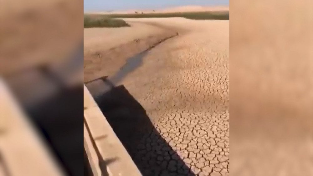
A prolonged drought has caused reservoirs to dry up and has further worsened the water crisis in Iran
From October to November, the country received only 2.3 mm (0.09 inches) of rainfall — 81% below normal. The crisis has become particularly acute over the past weeks, although Iran has been battling drought for six consecutive years.
The Ministry of Energy has already warned: if rains do not arrive in the coming weeks, water supply will have to be rationed and, if necessary, completely shut off at night across the entire country.
The president has even mentioned a possible partial evacuation of the capital.
According to the Iranian Meteorological Organization, the drought is primarily linked to the intensification of subtropical high pressure — an atmospheric system that is typically active in summer, but this year persisted into late autumn and blocked incoming rain-bearing fronts. Similar conditions are observed in Iraq, Syria, and Turkey.
China
On November 11, in Sichuan Province, the recently constructed Hongqi Bridge—known as the “bridge in the clouds” and opened to traffic in January 2025—partially collapsed.
The total length of the Hongqi Bridge is 758 m (2,487 ft), with a main span of 220 m (722 ft) and support pillars 172 m (564 ft) high; the bridge has a Y-shaped design and crosses the Dadu River.
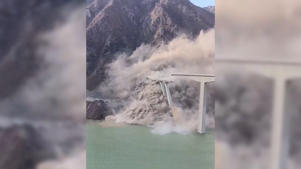
Partial collapse of the new Hongqi Bridge in Sichuan Province, China
The incident occurred on National Highway 317 near marker K381 in the city-county of Maerkang, Ngawa Tibetan and Qiang Autonomous Prefecture.
The day before, on November 10, inspectors discovered cracks about 10 cm (3.9 inches) wide in the bridge structure and the adjacent slope, posing a safety threat. A temporary traffic ban was introduced. The next day, deformation of the slope intensified, a section of the span partially collapsed, and concrete blocks fell into the gorge, raising a cloud of dust.
According to preliminary reports, there were no casualties. Traffic is being routed via detours.
A week earlier, on November 3, in Yunnan Province (Jingdong Yi Autonomous County of Pu’er Prefecture), after prolonged downpours, massive slope failures and subsidence of the roadway occurred on a section of the Nanjing Expressway, which had been opened only three years ago.
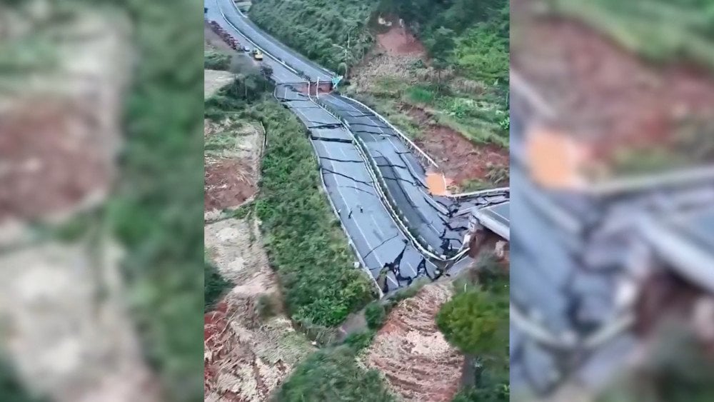
Slope failures and roadway damage on the Nanjing Expressway after heavy rains in Yunnan Province, China
On November 5, traffic on the affected sections was restricted, and detour routes were organized. According to local authorities, there were no casualties, and reconstruction works are underway.
Social media users are debating whether construction violations may have occurred, but final conclusions will be made by expert examination. What is perfectly clear, however, is that climate disasters are not only rapidly intensifying but also changing in character, and even the most advanced technologies and strict adherence to standards no longer guarantee the safety and resilience of structures.
It is evident that the intensification of natural disasters requires comprehensive interdisciplinary study. The world needs not just observational science, but fundamental and applied research that can help in practice to mitigate the aftermath of climate disasters and eliminate their causes.
And here is the truly important news — the ALLATRA Global Research Center is already operational. This is not a formal project “for reporting purposes,” but a live international scientific platform where researchers from different countries work together toward one goal — to save life and the future of the planet. There are no sponsors or political pressure here — only science and voluntary cooperation.
This approach makes it possible to conduct an honest analysis of what is truly happening with the climate. The key feature of the Center is complete openness: all research results are published in open access. This means that anyone — whether a scientist or simply a person who cares about the world — can see the truth. And it will no longer be possible to hide it behind “reassuring” statements such as “everything is under control.”
The ALLATRA Global Research Center is a step toward science that serves people, and a chance to find a real way out of the climate crisis.
Watch the video version of this article here:
Leave a comment