Summary of climate disasters on the planet from July 9 to 15, 2025
Every year, hail around the world is becoming larger and more dangerous. To grasp the scale of the threat, it’s enough to look at the events of the past week — from July 9 to 17, 2025.
Why are giant ice stones falling from the sky? And how is this connected to a fatal mistake made by humanity? Today, we’ll talk about that too.
Romania
On July 12, residents of the commune of Vânători-Neamț, Neamț County, experienced an anomalously intense event: a massive amount of hail covered the ground and rooftops, creating the illusion of a winter snowfall in the middle of summer.
Due to the severe weather, visibility dropped sharply, and the road was quickly coated in ice, becoming a major hazard for drivers.

After the anomalous hailstorm, the streets turned into an ice rink, posing a serious challenge for drivers, Vânători-Neamț commune, Neamț County, Romania
The temperature dropped from +30 °C (86 °F) to +12 °C (53.6 °F) in just 10 minutes.
Ukraine
For several consecutive days, powerful storms swept across Ukraine.
On July 10, the storm struck the western part of the country — the Lviv, Volyn, and Ternopil regions.
In Lviv, 110.2 mm (4.34 in) of rain fell in just 12 hours, which is 115% of the monthly norm, setting a new record for the city’s entire meteorological history. The previous record was set 59 years ago, when 86.3 mm (3.4 in) of precipitation fell in a day.
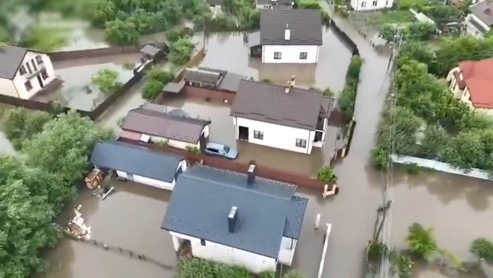
Aftermath of the record rainfall — flooded streets and houses, Lviv region, Ukraine
City streets were submerged, and people were trapped in their homes. They had to be evacuated by boat.
Nearby rivers overflowed their banks, flooding hundreds of houses and vehicles. More than 44,000 homes lost power.
A day earlier, on July 9, a tornado was recorded in the Lviv region near Zhydachiv. On July 10, in Cherkasy and Kyiv regions, squall winds brought down trees onto roads and buildings. Streets were flooded, and hundreds of settlements were left without power.
In several districts of the Kyiv region — Boryspil, Brovary, and Pereiaslav — anomalously large hail fell, with some stones the size of a chicken egg. It damaged cars and rooftops, and destroyed crops and gardens.
In the Poltava region, storms raged for two days straight, also bringing massive hail. The storm left destruction in dozens of villages.

A strong storm with hail damaged greenhouses and destroyed the future harvest, Poltava region, Ukraine
On the evening of July 12, a powerful downpour with wind gusts reaching 20 m/s (72 km/h or 44.7 mph) struck Ukraine’s Kharkiv region.
The storm brought down a tower crane, and a fallen tree hit a commuter train, prompting the evacuation of passengers. Dramatic footage of a ball lightning has gone viral online.
Tragically, one woman lost her life. Five others, including a 7-year-old girl, were injured.
Spain
Starting July 11, a powerful storm system known as DANA spread across a large part of northeastern Spain.
DANA is a type of upper-level cyclone that most often forms in early autumn over the Mediterranean Sea and brings extreme downpours, thunderstorms, and flooding.
The storm first struck the region of Aragón, Zaragoza province, where 72 mm (2.83 in) of rain fell in the municipality of Tarazona.

Aftermath of heavy rainfall — streets of Tarazona turned into rivers, Zaragoza province, Aragón, Spain
The rain was accompanied by hail and wind. Water surged through the streets, sweeping away everything in its path. Homes, businesses, and numerous retail and office buildings were flooded.
On July 12, a red-level weather alert was issued for the entire territory of Catalonia. From July 11 to 12, the municipality of Vilafranca del Penedès, Barcelona province, recorded 155 mm (6.1 in) of rainfall.
The intensity of the rain was also striking: in the city of Igualada, Anoia district, almost a full month’s worth of rain — 27 mm (1.06 in) — fell in just 10 minutes, and within one hour, three times the monthly norm — 87 mm (3.43 in) — was recorded (the average rainfall for July is about 30 mm or 1.18 in).
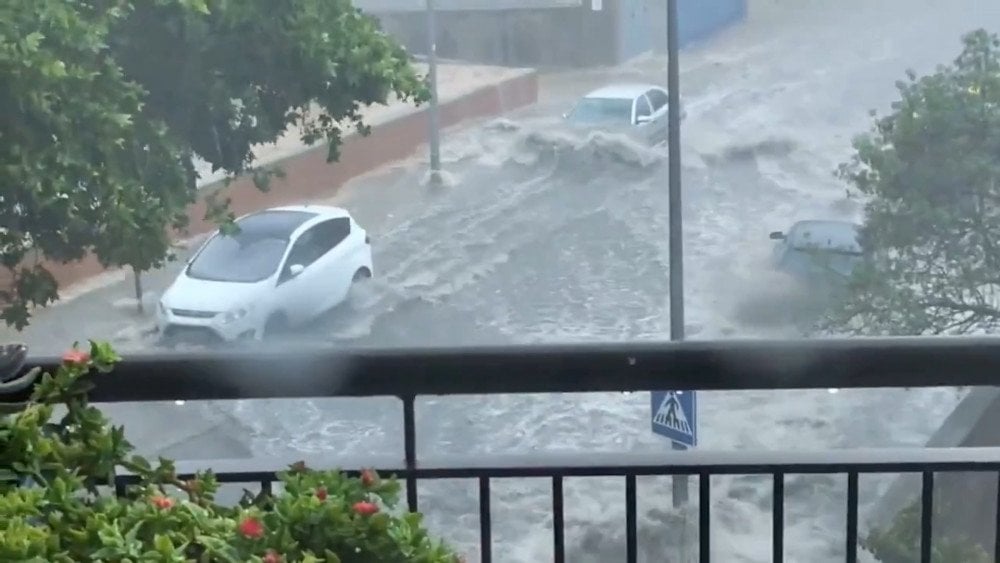
Raging torrents on the streets of Igualada after the intense downpour, Anoia district, Catalonia, Spain
Due to the flood threat, the national rail company Renfe completely halted suburban and regional train service across Catalonia — as a result, around 150 people spent the night at the Sants station in Barcelona.
At a hospital in Vilafranca del Penedès, part of the exterior wall collapsed under the force of the storm. Torrential water flooded the ground floor, reaching depths of up to 1.5 m (4.9 ft) in some areas. The damage was extensive, prompting authorities to shut down the facility, with reports indicating it may remain closed for two to three weeks.
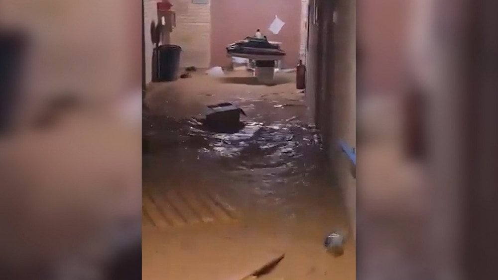
Aftermath of the severe storm: flooded hospital in Vilafranca del Penedès, Alt Penedès district, Barcelona province, Catalonia, Spain
At Barcelona airport, weather conditions forced multiple changes in takeoff and landing procedures — leading to schedule disruptions and flight delays. A plane bound for the United States was forced to return after hail completely destroyed the nose section of the aircraft.
During the storm, more than 26,000 lightning strikes were recorded. Due to various storm-related incidents in Catalonia, 75 people sought medical help.
Valencia was also affected by the heavy rain, especially Castellón province: in the municipality of Burriana, large hail fell; in Sagunto, streets were flooded, and strong winds made it nearly impossible to go outside.
DANA is not uncommon in Spain. Such phenomena usually occur in autumn, when the warm sea surface interacts with cold air masses, creating the conditions for intense rainstorms. But the appearance of a DANA system in July — and with such intensity — is a climate anomaly.
El Salvador
On July 10, a powerful hydrothermal explosion occurred near the Santa Teresa resort in the Ahuachapán department — at the site of the largest geyser in Central America.
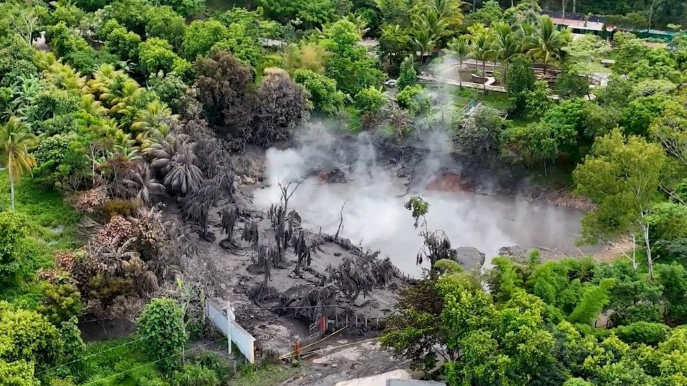
Steam, mud, and scorched trees — aftermath of the thermal explosion of Central America's largest geyser in El Salvador
This geyser is not just a tourist attraction — it is an active hydrothermal vent with a diameter of 70 m (230 ft) and a depth of 20 m (66 ft). The temperature of the water and steam inside it reaches 350 °C (662 °F) year-round.
The ejection of boiling water, steam, and fragments of volcanic rock damaged tourist infrastructure. Trees and roads were coated in scalding mud. Fortunately, no one was injured — all people managed to evacuate the danger zone in time.
A local resident recalled that during the last explosion of the same geyser in 1989, which claimed 32 lives, her relatives were burned alive. To this day, she said, people are not informed of the risks and receive no guidance in case of another eruption. Experts are urging a ban on construction within 200 m (656 ft) of the hazardous zone.
Some specialists link the geyser’s eruption to seismic activity in Guatemala, where more than 570 tremors were recorded over 5 days starting July 8. The strongest — with a magnitude of 5.7 — occurred on July 8 at 15:41 local time in the Escuintla department. The earthquake’s hypocenter was at a depth of 10 km (6.2 mi). As a result, 7 people were killed, dozens of homes and roads were destroyed, and hundreds were evacuated from high-risk areas.
Destroyed building after the earthquake in Escuintla department, Guatemala
India
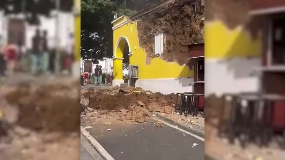
On July 9, in the Indian state of Gujarat, where heavy rains had been falling for several days, a section of the NH 64 national highway — a key transportation route connecting Central Gujarat and the Saurashtra region — suddenly collapsed.

In Gujarat state, India, a bridge slab between two supports collapsed — a ground tanker narrowly avoided falling into the void
Several vehicles crossing the bridge at that moment plunged into the Mahi River. A fuel tanker was left teetering at the edge, miraculously held in place by the remaining part of the structure.
As a result of the incident, 20 people were killed, one remains missing, and five were rescued.
Belarus
Starting July 9, Belarus also came under the grip of an extreme storm. Squall winds with gusts up to 24 m/s (86.4 km/h or 53.7 mph) and thunderstorms caused power outages in 170 settlements across the country.
The most severe damage to the energy infrastructure was recorded in the Hrodna, Mahilioŭ, and Minsk regions.
Hurricane-force winds felled or damaged over 1,900 hectares (4,695 acres) of forest — 90% of which was in Mahilioŭ region, the area that took the brunt of the storm.
In the city of Mahilioŭ, a woman was killed: she and her husband had taken shelter under a tree during the storm, but it collapsed under the force of the wind and fell directly on her. Four other people injured during the storm were hospitalized.
An EF2-category tornado swept through the village of Varkhi in the Viciebsk region. It not only uprooted trees but also tore off roofs and even entire walls of houses.
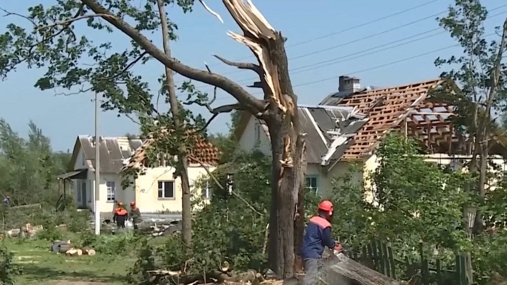
Aftermath of the tornado: trees broken and roofs torn off houses, Varkhi village, Haradok district, Viciebsk region, Belarus
Minsk saw an extremely dense rain severely reducing visibility. In some areas, large hail fell and damaged vehicles. Meteorologists had issued a warning about the approaching thunderstorm front, but few expected precipitation of such intensity.
Russia
Throughout the week of July 9–15, Russia was hit by a series of weather anomalies.
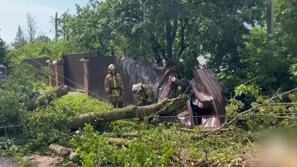
On July 9, the southern part of Pskov Region was struck by a storm moving from Belarus. The Velikoluksky District was the hardest hit.
Strong winds, heavy rain, and a tornado (estimated EF1–EF2) caused significant destruction: trees were toppled, power lines were damaged, and many homes suffered roof damage.
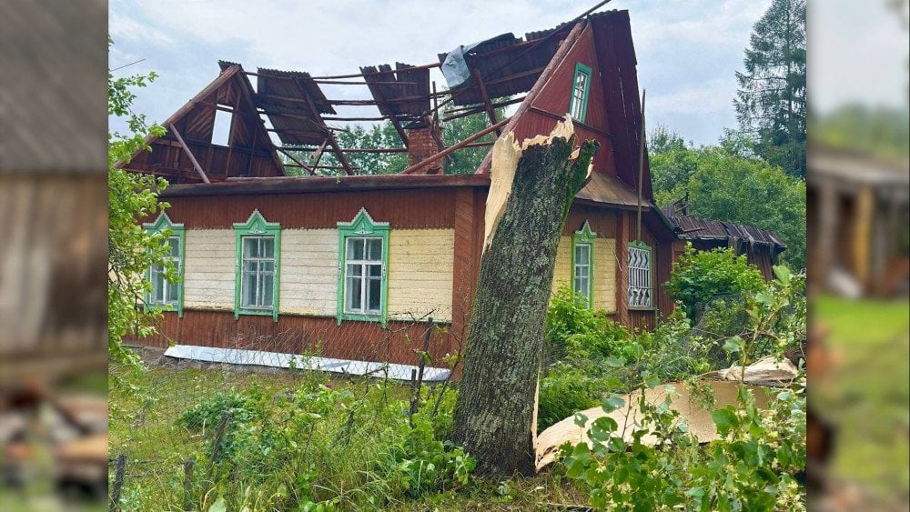
A tornado swept through Velikoluksky District in Pskov Region, leaving a trail of destruction, Russia
Hail the size of a chicken egg smashed greenhouses and destroyed crops.
Utility crews had to restore more than 1,900 km (1,180 mi) of power lines and reconnect 1,199 transformer substations.
A section of the federal A-122 highway (Velikiye Luki – Nevel) was blocked by fallen trees.
In Veliky Novgorod, 31 mm (1.22 in) of rain fell in 24 hours from July 9 to 10 — nearly half the monthly average (July norm is 67 mm or 2.64 in).
Lightning struck a substation, causing a fire and leaving part of the city without power.
After the storm, utility crews removed around 1,200 trees in the Pskov and Novgorod regions.
A severe storm in Novgorod Region knocked down trees and damaged power lines, Russia
Two days later, another — even stronger — storm hit Novgorod Region. The thunderstorm brought squall winds so intense that, according to local residents, they had never witnessed anything like it in their lifetime.
The storm left residents in 20 of the region’s 22 districts without power — affecting 485 settlements.
From July 9 to 15, Moscow and the Moscow Region were swept by a wave of natural disasters. Anomalous heat was replaced by hailstorms, record-breaking downpours, and hurricane-force winds. Cars, homes, and infrastructure were damaged, and lightning strikes sparked a series of fires.
On July 9, severe weather hit Solnechnogorsk, Zelenograd, Fryazino, Klin, Korolyov, and other towns in the Moscow Region.
In the city of Zelenograd and the village of Alabushevo, hail up to 7 cm (2.75 in) in diameter fell. At Sheremetyevo Airport, wind gusts reached hurricane strength — 33 m/s (119 km/h or 74 mph).

Large hail fell in the Moscow Region, Russia
On July 12, Moscow was hit by a tropical downpour after a 36 °C (96.8 °F) heatwave—at Balchug Station, +36.1 °C was recorded, breaking the 1903 record of +34.5 °C).
A quarter of the monthly rainfall fell in just a few hours. Electric trains at the “Three Stations Square” terminal came to a halt due to broken overhead lines.
On July 14, during a thunderstorm, heavy rain again flooded streets, building entrances, and parking lots. In some districts — Kuntsevo and Troitsky in Moscow, Istra and Odintsovo in the Moscow Region — lightning strikes caused residential homes to catch fire.

Fires from lightning strikes: homes burned down in the Moscow Region, Russia
On July 15, in less than two hours, an entire month’s worth of rainfall fell in some areas.
In northern and eastern Moscow, streets were submerged, underpasses and metro stations flooded, cars were stranded, and electric trains and Aeroexpress services stopped.
On July 12, powerful winds swept through Russia’s Samara Region, with gusts reaching up to 24 m/s (86.4 km/h or 53.7 mph). The storm ripped roofs off homes, uprooted trees, and caused extensive damage to vehicles.
The storm affected the settlements of Volzhsky, Grannyy, and the village of Tashla.
On the Volga River near Samara, a small boat capsized — a young woman died. Five other people were rescued.
In the Krasnoglinsky District, a tree fell on a tent with campers inside, killing two people.
On July 14, at the beach of the Shakhtyor park hotel in the village of Buneryovo, Tula Region, lightning struck wet sand during a thunderstorm. Tragically, three people — including a child — died instantly. Three more were injured.
Latvia
On July 11, a severe storm with downpours, gusty winds, and destructive hail struck several regions of Latvia.
In the settlement of Palsmane, Smiltene Municipality, the largest hailstones ever recorded in the country’s meteorological history were observed — reaching a size of 11.5 cm (4.53 in).
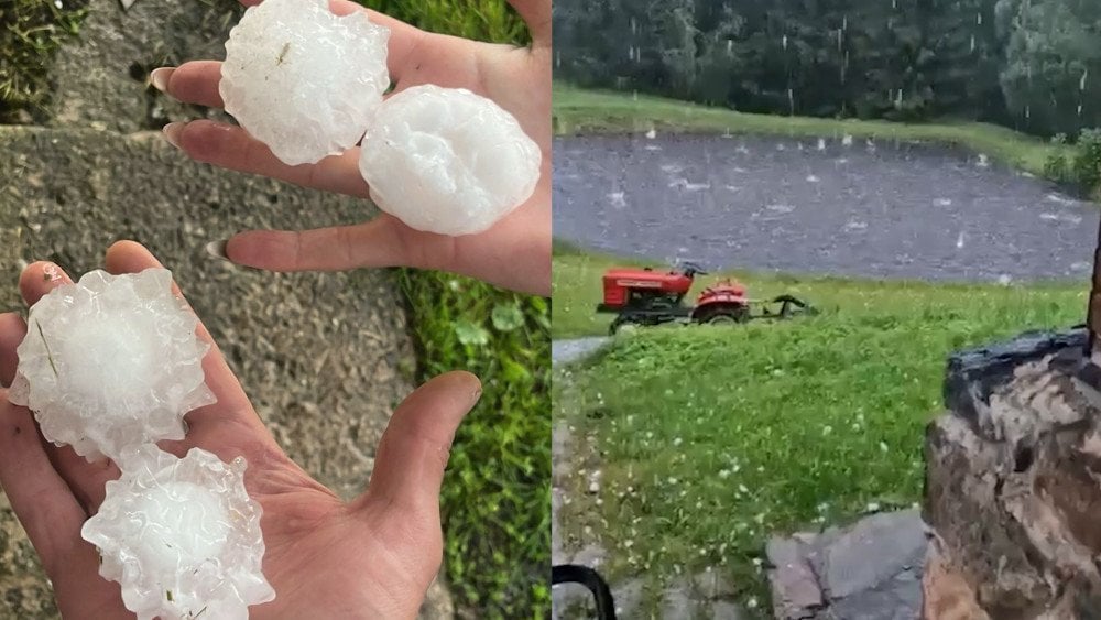
Giant hail fell in the settlement of Palsmane, Smiltene Municipality, Latvia
This is the first officially registered case of giant hail in Latvia, entered into the European Severe Weather Database (ESWD).
Hailstones measuring ≥ 10 cm (3.94 in) are classified as giant hail.
The storm damaged house roofs, vehicles, and destroyed solar panels.
Hail is turning into a real disaster around the world — it’s shocking how often it happens now, and how huge the hailstones have become—something that seemed impossible just yesterday. It smashes cars and rooftops, destroys crops, and injures people. And these are no longer isolated incidents — this is a new, deadly climate trend.
Take a look at the graph that shows the rapid increase in large hail events across Europe. The growth is exponential.
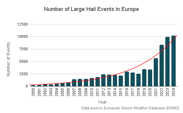
Rising trend in the number of large hail events in Europe
Alongside the rise in global temperature and atmospheric moisture — conditions that favor hail formation and size increase — there is another factor behind the sharp spike in hail incidents.
This factor was created by us, humans, with our own hands. We ourselves have created an invisible enemy that most people aren’t even aware of. And this has become humanity’s fatal mistake. We’re talking about plastic.
It’s no longer just trash in the oceans and soil. Under the influence of sunlight, salt, and mechanical friction, plastic breaks down into microscopic fragments—microplastics and nanoplastics. These particles are everywhere: in water, in soil, and in the air. They rise into the atmosphere with sea breezes, evaporation, and precipitation, spreading thousands of kilometers.
The danger of micro- and nanoplastics lies in their ability to accumulate electrostatic charge on their surface. This is what makes them active participants in atmospheric processes. In the air, charged nanoparticles act as condensation nuclei — the points around which water droplets and ice crystals form. This accelerates cloud formation and causes droplets to freeze at temperatures 4–10 °C (39.2–50 °F) higher than normal.
In simple terms, plastic has already become a climatically active substance. It affects weather patterns, participates in the formation of rain, snow, and hail, and may even pose a threat to aviation.
All these facts clearly show just how dangerous plastic is and how much it already affects our lives. But what scientists have discovered about its effects on the human body has truly shocked them. Find out what they uncovered in Dr. Egon Cholakian’s new video, as well as in the scientific report by the ALLATRA researchers.
You can watch the video version of this article here:
Leave a comment