Summary of climate disasters on the planet, August 20–26, 2025
Destroyed resorts in Italy, cities in Brazil buried under ice, a rare outbreak of waterspouts in Poland. Even the Arctic has updated its temperature records.
Behind these and other climate anomalies of the past week, from August 20 to 26, 2025, lies “something” greater. In this article, we will show how exactly this “something” may turn out to be the most dangerous process of our time.
Italy
On August 24, a powerful storm struck coastal settlements in the Italian region of Emilia-Romagna — the provinces of Ravenna, Forlì-Cesena, and Rimini were affected.
Wind gusts reached 122 km/h (76 mph). Fallen trees and billboards blocked roads and disrupted railway traffic. Twenty-three people were evacuated from a train stranded on the tracks.
In Milano Marittima, one of the most prestigious resorts of the Adriatic coast, beaches and bathing complexes were especially hard hit. The wind broke umbrellas, gazebos, tore canopies, and toppled 265 trees. In some areas, the drinking water supply was cut off.

Aftermath of a powerful storm at the resort of Milano Marittima in the Italian region of Emilia-Romagna
In the city of Rimini, 74 mm (2.9 in) of rainfall fell within 6 hours (against the August monthly average of 39.2 mm / 1.5 in), with 50 mm (2 in) of it in just 20 minutes. Roads and underpasses were flooded.
In just a few hours, the disaster destroyed up to 80% of the vegetable crop harvest.
Romania
On August 23, Romania faced the aftermath of a powerful Mediterranean cyclone.
Storms hit 18 counties of the country and the capital, Bucharest. In some areas, the temperature dropped by 10 °C (18 °F) compared to the previous day. Strong winds toppled hundreds of trees and power line poles, as well as damaging more than 70 cars. Heavy rains flooded basements and courtyards.

Strong wind in Romania toppled trees, blocking roads and damaging cars
In Ilfov County, Wallachia region, two people drowned on Lake Snagov, north of Bucharest, when a sudden storm overturned their boat.
And in Argeș County, Wallachia region, an 18-year-old boy was killed under the debris of a collapsed roof.
Guinea
On the evening of August 20, torrential rains triggered a powerful landslide in the district of Friguiadi Nord, Maneah commune, 50 km (31 mi) from Conakry, the capital of Guinea. A residential district at the foot of Mount Kakoulima was affected.
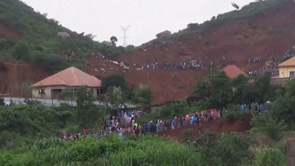
Heavy rains triggered a deadly landslide in the Friguiadi Nord district, Maneah commune, Guinea
According to eyewitnesses, everything happened suddenly: “It was raining, and suddenly the earth from the mountainside shifted, burying the houses.” Twenty-two buildings were buried under tons of soil, ten of them were residential.
Civil defense units and the military joined the rescue operations. Cynologists with dogs worked on-site, heavy machinery was used, and residents manually cleared the debris.
Several victims were pulled out alive and taken to hospitals. One of them was a teenager who managed to hide after hearing the sound of the landslide.
As of August 22, 12 people were injured, 16 lost their lives, and 10 more remain missing.
Among those killed in the landslide was a family: parents and four children. The only survivor — a young man who happened to be on duty several kilometers from the site of the disaster.
Russia
In the area of the Siberian magma plume, temperature anomalies are once again being recorded.
In the Arctic, unprecedented heat was registered: on August 20, on Vize Island in the Kara Sea, for the first time in history, the thermometer showed +11.6 °C (52.9 °F), immediately surpassing the previous monthly record of +9.1 °C (48.4 °F), set in 2024, by 2.5 °C (4.5 °F).
From August 8 to 25, 13 temperature records were broken: August 8 Tmax = +8.1 °C (46.6 °F); August 9 Tmax = +8.2 °C (46.8 °F); August 10 Tmax = +8.8 °C (47.8 °F); August 11 Tmax = +8.3 °C (46.9 °F); August 13 Tmax = +6.9 °C (44.4 °F); August 15 Tmax = +6.2 °C (43.2 °F); August 16 Tmax = +6.1 °C (43.0 °F); August 20 Tmax = +11.6 °C (52.9 °F); August 21 Tmax = +8.7 °C (47.7 °F); August 22 Tmax = +7.3 °C (45.1 °F); August 23 Tmax = +7.3 °C (45.1 °F); August 24 Tmax = +7.0 °C (44.6 °F); August 25 Tmax = +8.7 °C (47.7 °F).
The anomalously high temperatures were accompanied by a thunderstorm — an extremely rare phenomenon for these latitudes, recorded here only for the third time in the 21st century (the previous thunderstorms occurred in 2006 and 2016).
On August 20, in the village of Zhilinda, Yakutia, the air warmed to +27.7 °C (81.9 °F) (while the monthly average is +15.6 °C / 60.1 °F), setting a new daily record.
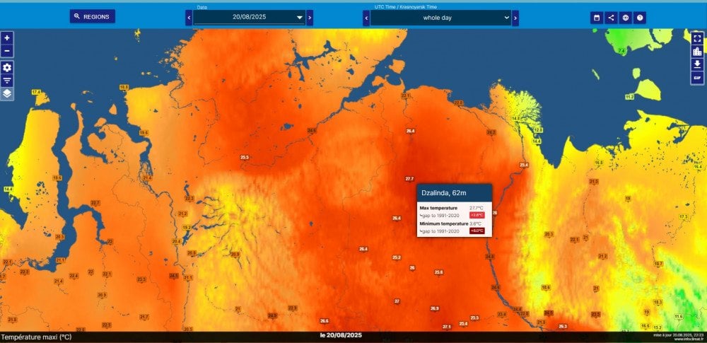
Anomalous warmth settled over Siberia, Russia
On the same day, in the north of the Taymyr Peninsula, at Cape Sterlegov, thermometers showed +23 °C (73.4 °F), while the monthly average maximum is +6.6 °C (43.9 °F).
On Dikson Island, new temperature records were recorded for 8 days in a row: August 19 Tmax = +22.5 °C (72.5 °F); August 20 Tmax = +20.3 °C (68.5 °F); August 21 Tmax = +20.1 °C (68.2 °F); August 22 Tmax = +18.8 °C (65.8 °F); August 23 Tmax = +19.0 °C (66.2 °F); August 24 Tmax = +22.6 °C (72.7 °F); August 25 Tmax = +21.3 °C (70.3 °F).
The peak came on August 24, when the air warmed to +22.6 °C (72.7 °F), exceeding the norm by more than 14 °C (25.2 °F) (the monthly average is +8.3 °C / 46.9 °F).
In the city of Norilsk, where, according to scientists, the center of the magma plume is located, anomalously high temperatures also persisted.
According to meteorologists, the average August temperature in Norilsk turned out to be higher than in cities located thousands of kilometers further south: August 23 Tmax = +23.4 °C (74.1 °F); August 24 Tmax = +25.0 °C (77.0 °F); August 25 Tmax = +25.3 °C (77.5 °F); August 26 Tmax = +24.7 °C (76.5 °F). Tavg max for August = +15.9 °C (60.6 °F).
Yemen
From August 22, large-scale floods engulfed many provinces of Yemen. The long-awaited rains turned into a catastrophe.
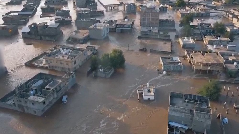
Catastrophic flooding in Yemen caused enormous damage to infrastructure and residential areas
In the country’s largest city, Aden, residential neighborhoods were affected, and the first floors of buildings were flooded. Some districts turned into lakes. Floodwaters mixed with sewage, creating the threat of epidemics. Roads were blocked with rocks and mud, paralyzing traffic. A damaged bridge cut off traffic on the international highway between Aden and Taiz. Residents said that such rainfall had not been seen here for more than 40 years.
In Abyan Province, in the Ahwar district, a family of ten miraculously survived after their car was swept away by a powerful stream of water. They managed to escape by climbing to higher ground.
In the village of Al-Hadra, Kaidna district of Hajjah Province, a house collapsed, leading to the deaths of three children and injuries to their parents.
As of August 26, the disaster claimed 14 lives, with dozens injured.
Across the country, damage was inflicted on infrastructure and agricultural lands, and numerous livestock were lost.
Brazil
From August 20, a series of storms struck Rio Grande do Sul State. First, a warm front brought strong winds exceeding 100 km/h (62 mph), heavy rain, hail, and more than 300,000 lightning strikes. In the municipality of Rolante, wind speeds reached 109.4 km/h (68 mph).
The cold front that followed intensified the rains. In just two days, some areas in the central and southern parts of the state received more than 200 mm (7.9 in) of rainfall.
In the basin of the San Lourenço River, up to 300 mm (11.8 in) was recorded, which exceeded two monthly norms: the average monthly rainfall here in August is 117 mm (4.6 in).
As a result, the river overflowed its banks, flooding more than 2,000 houses. The water advanced quickly — entire streets became impassable, cars were submerged, and some residents had to be rescued by boat. More than 500 people were forced to leave their homes.
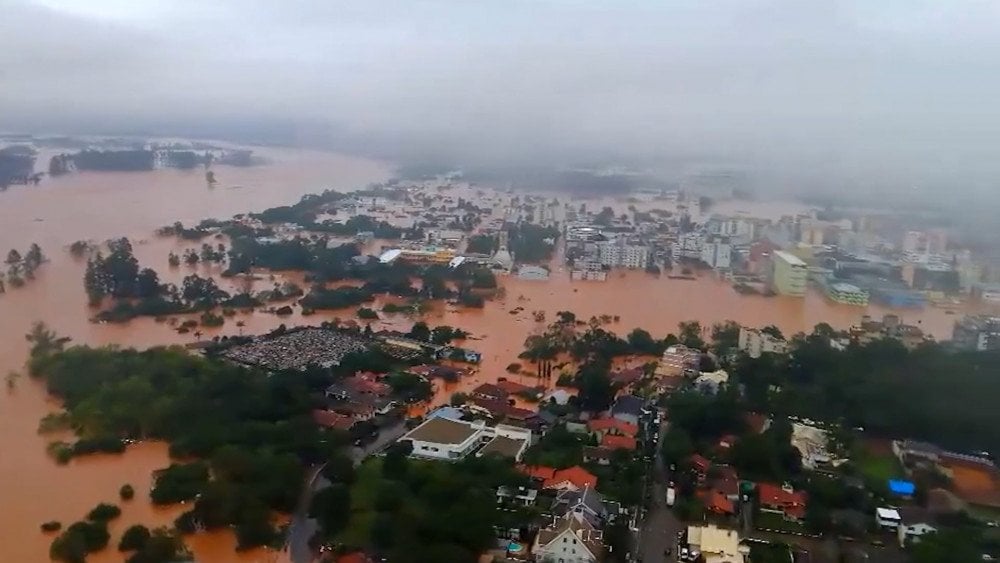
Large-scale flooding in Rio Grande do Sul state, Brazil, after record rainfall
In the state capital, Porto Alegre, 125 mm (4.9 in) of rain fell in two days, also exceeding the August monthly norm.
Across the region, reports came in of flooding, damaged roofs, fallen trees, and blocked roads.
A state of emergency was declared in Rio Grande do Sul.
On the morning of August 26, the municipality of Castro, Paraná State, was hit by a powerful hailstorm. In just 20 minutes, everything around was buried under ice.
The disaster spared no buildings: schools, medical and sports facilities were damaged, a construction store was completely destroyed, and a church lost its roof — at least 600 buildings were affected.
Federal Highway PR-151 was covered with ice, becoming hazardous for drivers. Hail also struck other cities, including the state capital, Curitiba.
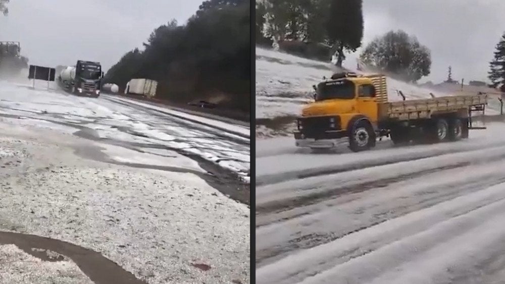
Heavy hail created dangerous road conditions in the municipality of Castro, Paraná state, Brazil
Seismic activity
A 7.5 M earthquake struck on Thursday, August 21, at 23:16 LT in the Drake Passage, about 710 km (441 mi) from the city of Ushuaia in Argentina. The hypocenter lay at a depth of 10.8 km (6.7 mi). Initially, the U.S. Geological Survey (USGS) assigned this quake a magnitude of 8.
It is important to note that the Drake Passage in 2025 is experiencing an anomalous surge in seismic activity. While over the past quarter century, from 2000 to 2024, according to the USGS, only 51 earthquakes of magnitude 4.5 and above occurred here, in less than 8 months of this year, 11 such shocks have already been recorded.
Moreover, two of them had magnitudes above 7, which is an extremely rare phenomenon for this region, where in the entire history of observations since 1890, only three such earthquakes had been registered.
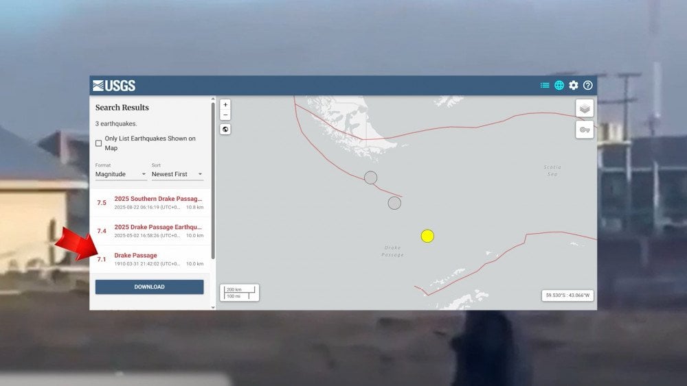
Rare phenomenon: two powerful earthquakes above magnitude 7.0 occurred in the drake passage in 2025
On August 26, at 23:33 LT, a strong M5.7 earthquake occurred in the Caspian Sea at a depth of 50 km (31 mi). The epicenter was located 39 km (24 mi) from the city of Izberbash, Dagestan, Russia. The hypocenter lay at a depth of 50 km (31 mi).
The shaking was also strongly felt in the cities of Makhachkala, Kaspiysk, Derbent, and Buynaksk. In high-rise buildings, chandeliers swayed, glass rattled, dishes fell. People ran out into the streets in panic, many remaining outside until morning, fearing new shocks. In stores, goods fell from shelves, and at a football match, one player was knocked down by the earthquake.
Seismic waves spread far beyond Dagestan — tremors were felt in several regions of Russia, including Astrakhan and Volgograd Oblasts, as well as in Azerbaijan, Armenia, Georgia, Kazakhstan, Iraq, Iran, Syria, Turkmenistan, Turkey, and Uzbekistan.
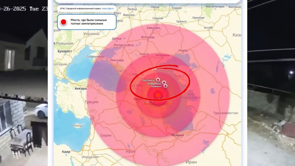
Powerful magnitude 5.7 earthquake in the Caspian sea
Fortunately, there were no casualties or major destruction.
Specialists are concerned about the absence of aftershocks following the earthquake — this is unusual for such events. According to their assessment, not all the accumulated energy may have been released, and the current tremor could foreshadow a stronger seismic event.
Meanwhile, in Kamchatka, Russia, aftershocks are not subsiding. Since the M8.8 mega-earthquake on July 30 at 11:24 LT in the Pacific Ocean, 149 km (93 mi) from the city of Petropavlovsk-Kamchatsky (hypocenter at a depth of 17 km / 10.5 mi), more than 12,000 seismic events have already been recorded. And their magnitude remains high.
From August 25, earthquakes above magnitude 6.0 were registered for three consecutive days in the Pacific Ocean:
- On August 25, an M6.6 earthquake occurred at 18:48 LT, 323 km (201 mi) from Severo-Kurilsk. Hypocenter depth: 40 km (25 mi).
- On August 26, an M6.1 earthquake occurred at 10:13 LT, 196 km (122 mi) from Severo-Kurilsk. Hypocenter depth: 31 km (19 mi).
- On August 27, an M6.2 earthquake occurred at 15:49 LT, 276 km (171 mi) south of Petropavlovsk-Kamchatsky. Hypocenter depth: 66 km (41 mi).
Residents of certain districts of Petropavlovsk-Kamchatsky felt light shaking.
One of the seismic events was very powerful — its magnitude reached 6.6.
Waterspouts
On August 21, an extraordinarily rare natural phenomenon was observed over the Baltic Sea — a major outbreak of waterspouts.
According to climatological standards, small outbreaks include 5–9 waterspouts per day, moderate ones 10–19, and major ones 20 or more.
According to observers, at least 20 funnels were recorded in total.
At least 12 vortices formed in the coastal waters of Poland. And near the Danish island of Bornholm, according to the International Centre for Waterspout Research (ICWR), a unique event was documented — 8 waterspouts aligned in a single line simultaneously.
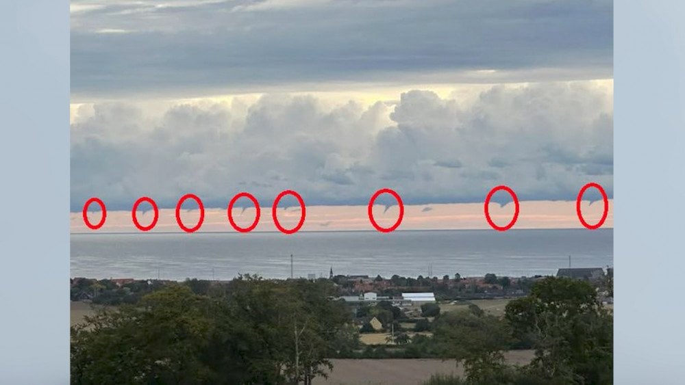
Rare waterspout outbreak: 8 spouts aligned in a row near the Danish Island of Bornholm
In Russia, waterspouts were also recorded for several days in the Baltic Sea area: in the Kaliningrad region and in the Gulf of Finland near Saint Petersburg.
Typhoon Kajiki
On August 24, Typhoon Kajiki brought chaos and destruction to the Chinese city of Sanya, Hainan Province.
It became the strongest typhoon ever recorded in this region, bringing wind gusts of more than 199 km/h (124 mph) and 389.2 mm (15.3 in) of rainfall (Qingtian village, Haitang District).
More than 20,000 trees were toppled, many cars ended up underwater, and the windows of some houses were shattered by strong winds.

Aftermath of typhoon Kajiki: in China’s Hainan province strong winds blew out windows in residential buildings
Over 7,000 households were left without water supply. As of August 25, a total of 102,500 people were affected in Hainan Province.
Weakening to a tropical storm, Kajiki did not lose its destructive force — on August 25 it struck the central and northern provinces of Vietnam with wind gusts up to 133 km/h (83 mph). The destruction was massive: more than 8,700 houses were damaged, 81,500 hectares (201,400 acres) of rice fields were flooded, and fruit orchards were destroyed.
At least 1.6 million people were left without electricity.

Vietnam after tropical storm Kajiki: streets turned into rivers, cars ended up underwater
Roads were flooded or blocked by landslides, 7 communes in Quang Tri Province were cut off from the outside world. More than 44,000 residents were evacuated to safe areas.
The disaster claimed 8 lives: seven in Vietnam and one in Thailand.
Conclusion
To wrap up today’s report, let’s return to the topic of “new norms” we touched on last time, and show how the edges of worsening climate extremes are being deliberately smoothed out.
Let’s take temperatures as an example.
The World Meteorological Organization (WMO) uses 30-year climate averages to measure how current weather deviates from the norm. These baselines are updated every 10 years to reflect a changing climate. On one hand, that makes sense: refreshed data help guide decision-making in energy, farming, health care, and other fields where climate matters. But here’s the catch: when those baselines include years filled with record-breaking extremes, the comparisons stop showing just how abnormal today’s conditions really are.
It’s like checking a patient’s fever but adjusting the thermometer each day to match yesterday’s reading. By the end of the week, a raging 104°F temperature looks like nothing more than a slight fever.
That’s why, for long-term monitoring, the WMO still recommends using the fixed period from 1961 to 1990. But in practice, that benchmark is rarely applied anymore. And you can probably guess why.
Even the process of averaging itself distorts the picture in this era of wild extremes. For instance, in February 2025, in the town of Ostrovnoy in Russia’s Chukotka region, the monthly average deviation from normal was just −1.7°C. But daily temperatures swung from 15 degrees below average to nearly 32 degrees above average — all within the same month! How do you like this “norm”?!
Here’s a fitting metaphor: drop a frog into boiling water and it jumps out immediately; put it in cool water and slowly heat it, and it won’t notice the danger until it’s too late.
That “boiling frog syndrome” in our society shows that due to the manipulation of climate data and the gradual shift in average values, even shocking anomalies are beginning to be considered normal, and the danger of what is happening is no longer taken seriously.
Draw your own conclusions.
You can watch the video version of this article here:
Leave a comment