Summary of Climate Disasters on the Planet from June 5 to June 11, 2024
Europe
Austria
On June 8, a powerful storm with torrential rain hit Austria. The city of Deutschfeistritz in the federal state of Styria was particularly affected. This region received over 100 mm (3.9″) of rainfall, turning streams into raging torrents. Residents of the city were asked to stay home due to life-threatening conditions.

Aftermath of a devastating flood, federal state of Styria, Austria
The Übelbach River overflowed. The flood damaged buildings and washed away cars. Helicopters were deployed to rescue people whose homes were cut off from the outside world.
In Neudau, federal state of Styria, a nursing home had to be evacuated due to severe flooding.
Five landslides occurred on the A9 motorway.
In some areas,
the layer of mud and debris reached 2 meters (6.6 ft),
due to which the road was temporarily closed.
A few small roads were also blocked by fallen trees.

Road services clearing mud and debris on the motorway after a landslide, Austria
Firefighters and transport company employees worked around the clock, using 20 trucks and 7 excavators to remove the piles of earth. The work was complicated by the enormous amount of floodwater and unstable ground, which continued to slide down the slopes.
On June 9, a passenger plane of Austrian Airlines, en route from Palma de Mallorca to Vienna, was seriously damaged during the flight.
An Airbus A320 on an approach to the Austrian capital was badly damaged by hail when the jet hit a “thunderstorm cell”.
The pilots were caught off guard as the storm was not visible on the weather radar.
Large hailstones pierced the outer shell of the cockpit windows and damaged the plane's nose.

Serious hail damage to an Austrian Airlines airplane
The pilots had to land at Vienna airport blind, using only instruments.
After landing, the passengers and the crew were shocked by the scale of the liner's damage.
According to an Austrian Airlines representative, the damage is estimated at several hundred thousand euros.
Türkiye
On June 6, a severe storm hit the Turkish capital Ankara. Squally winds ripped off the roof of a residential building, and the debris damaged nearby structures and vehicles. Bus stops were destroyed. Broken power lines caused widespread power outages.
A local resident described his experience during the storm, “It was beyond anything we've ever seen. Everything was destroyed within a minute. Our shop windows were shattered, and people ran away in panic.”
A large billboard fell from a strong gust of wind, killing one person and seriously injuring another.

Huge billboard collapsed from a powerful gust of wind, Ankara, Türkiye
Lightning struck a motorcycle, and the injured driver was taken to the hospital.
Over the next two days, from June 7 to 8, the city had 130% of the monthly rainfall average. The downpours led to severe flooding.
Road traffic was paralyzed, the metro stopped, and hundreds of cars with people were stranded by the water.

Flood paralyzed road traffic in Ankara, Türkiye
A sudden downpour, hail and thunderstorm hit Kayseri province on June 8. Winds toppled trees and blew off the roof of Nuh Naci Yazgan University.
Walnut-sized hail damaged dozens of cars. A local resident suffered a head injury from hail.

Aftermath of a hailstorm in Kayseri province, Türkiye
Spain
On June 10, sunny weather in eastern Spain suddenly changed to cold showers and gusty winds.
Large hail fell in the provinces of Alicante and Valencia. In the province of Murcia, roads turned into raging torrents carrying cars and garbage bins. Rivers overflowed their banks, rushing water onto desiccated fields and then crashing onto highways.
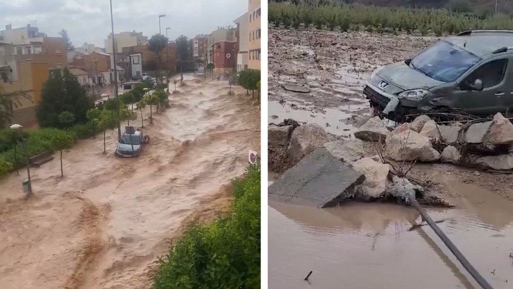
Powerful flood creates chaos on the streets of Spain
In the town of Calasparra, 67.8 mm (2.8") of rain fell in an hour, which is more than 5 monthly rainfall norms (the average monthly rainfall for June is 13.1 mm (0.5")). Trees, crops and infrastructure were severely damaged.
Downpours also caused flooding in many parts of the Spanish island of Mallorca.
The work of the capital's airport, which is the third largest in Spain, was paralyzed. The maximum amount of precipitation that fell within an hour reached 90 mm (3.5"). This was recorded by the weather station at the airport. The entrances to the terminal building and runways were flooded. Eyewitnesses said that there was chaos all around: passengers fled to escape the rain pouring through the roof and windows of the airport.
France
On the night from June 8 to 9, severe storms brought floods, mudflows and landslides to southern France. According to Météo-France, the department of Gers in the Occitania region saw more than 100 mm (3.9") of rainfall in just 5 hours, from 9:00 PM to 2:00 AM.
In some areas, roads were closed, and people had to be evacuated. The water level in the Gélise River reached 3.35 meters (11 ft), which is higher than during the last major flood in 1981.
Due to the storm, an animal shelter in the commune of Brax, Lot-et-Garonne department, was completely flooded. The dogs were rescued and moved to a safe place.

Animal shelter flooded during the storm, department of Lot-et-Garonne, France
South America
Brazil
Fires continue to devastate the Pantanal, the world's largest tropical wetland in Brazil. The region is shrouded in a thick layer of smoke.
The fire season in the Pantanal usually occurs from July to August.
This year,
it started abnormally early due to heat and a lack of rainfall.
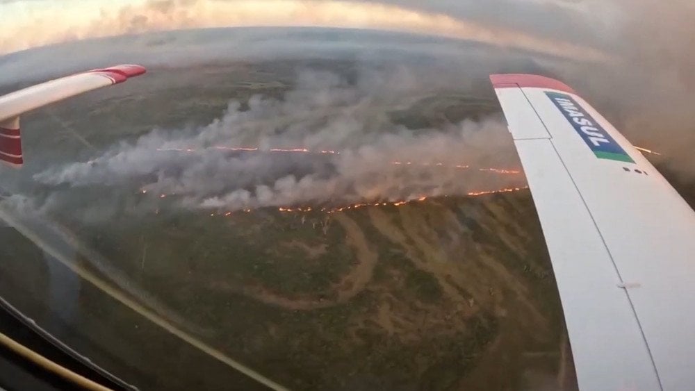
Natural fire in the Pantanal wetlands, Brazil
According to local meteorologists, the city of Corumba has had no rain for more than 50 days in a row.
The Paraguay River, the region's main water artery, is experiencing a historic drought. The water level near the town of Ladario dropped 2.47 meters (8.1 ft) below average. The situation in the Paraguay River basin is recognized as critical.
In the states of Mato Grosso do Sul and Mato Grosso, the number of fires in the first six months of 2024 increased by 1,025% compared to the same period last year.
- 106 fires from January 1 to June 7, 2023;
- 1,193 fires from January 1 to June 7, 2024.

Number of fires per year from 2010 to 2024, states of Mato Grosso do Sul and Mato Grosso, Brazil
The 2024 fires were the second largest in the last 15 years.
Asia
Vietnam
Heavy rains that started on June 8 caused floods and landslides in northern Vietnam, bringing terrible aftermath. Among the most affected regions are Quang Ninh, Ha Giang, Cao Bang provinces and Haiphong city.

Widespread flooding in Vietnam
As of June 11, 4 people died and 1 was missing, according to the Disaster Prevention Committee.
The Water Resources Department of Ha Giang Province reported that rainfall was incredibly intense from June 9 to 10. Within just 14 hours, 320 mm (12.6") of rain fell in various areas of the province, such as in Thuong Son commune.
Floods inundated over 2,000 homes. More than 2,400 hectares of rice fields and agricultural lands were flooded. Many livestock farms were damaged, resulting in the loss of hundreds of heads of cattle and poultry.

Torrential rains flooded homes and streets in various provinces of Vietnam
In Cao Bang province, rains and mudflows flooded houses, damaged irrigation facilities, and many educational institutions.
In Lao Cai province, a landslide blocked traffic on National Highway 4D. In Ha Giang province, around 400 foreign tourists were stranded for several hours in the mountainous area of Dong Van due to the disaster.
Russia
Residents of several regions in Russia were shocked to see tornadoes for the first time in their lives.
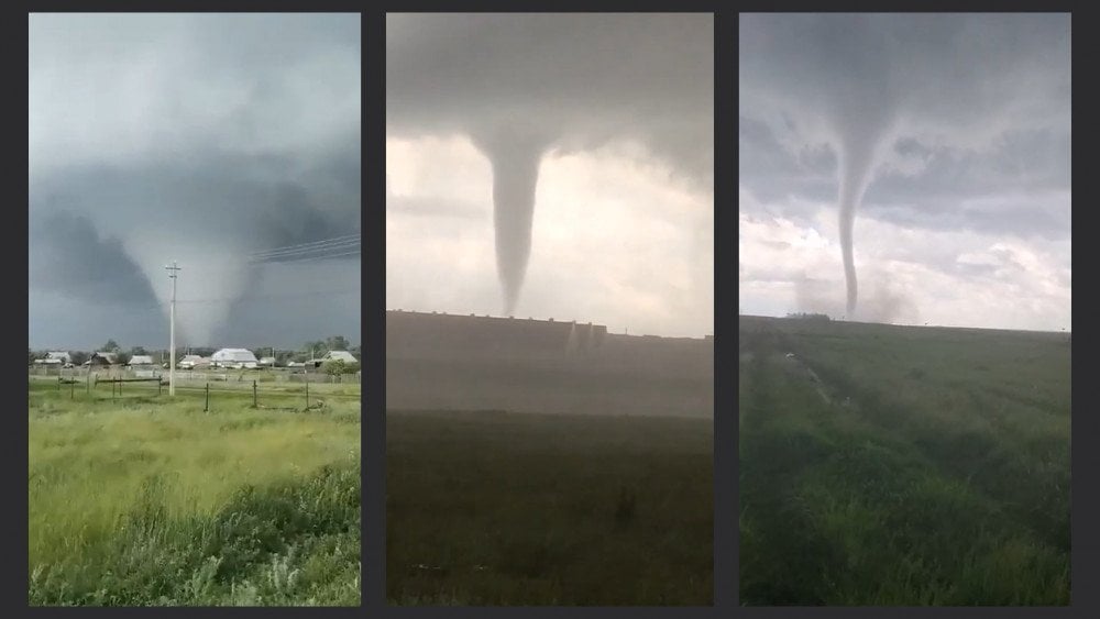
Unusual tornadoes in different regions of Russia
On June 6, two tornadoes swept through the Sverdlovsk region. Residents of Nizhny Tagil and Nizhnie Sergi witnessed this dangerous phenomenon.
On June 7, a tornado passed through the village of Berdyuzhye in the Tyumen region, ripping off roofs and uprooting fences. Metal roofs and poles were scattered across the streets, turning the village into a disaster zone.
It is worth noting that
the appearance of such a vortex in the Tyumen region is a unique event.

Aftermath of a tornado in Berdyuzhye village, Tyumen region
On June 8, a water tornado was seen over Lembolovskoye Lake in the Leningrad Region. This unusual for these latitudes natural phenomenon was clearly visible from the village of Vaskelovo.
On the same day, a large tornado swept through the Agapovsky district in the Chelyabinsk region, the Abzelilovsky district in Bashkiria and a village near Magnitogorsk, bringing destruction to the area.
A resident of the village of Chernigovsky, in the Agapovsky district, said: “It was eerie indeed, there was terrible wind, hail and sheeting rain. We thought the wind would shatter the windows and blow away the plastic walls of greenhouses; flower pots were flying around the yard.”
The whirlwind demolished everything in its path; roofs of residential houses, gas stations, cars, and power lines were damaged. Ten settlements were left without power. The tornado threw a truck off the road and overturned it several times, but the driver miraculously survived.
The Ural Hydrometeorological Center commented that this phenomenon is too rare for this region and has not been studied.
Central America
Costa Rica
On June 8, strong winds, lightning strikes, and hail caused chaos in the city of Cartago and surrounding areas in Costa Rica.
In the city center,
95 mm (3.7") of rain fell in less than 2 hours
(the average monthly norm for June is 149.1 mm (5.9")).

Flooded streets in Cartago, Costa Rica
The downpours caused widespread flooding. More than 50 homes were flooded. Hospital Max Peralta was also affected, as the water filled even inpatient wards. In some places, cars were submerged underwater. Several landslides occurred as well. Strong winds toppled trees, damaged power lines and tore off the roof of the Fello Meza stadium.
According to experts from the National Meteorological Institute (IMN), it was neither a whirlwind, nor a tornado, nor a hurricane. It was what they call a “downburst.”
This phenomenon can be explained by an associative example.
It is like pouring a huge bucket of water from the sky over a radius of about 5 km (3.2 miles). When this water hits the ground, it causes horizontal wind gusts
reaching speeds of up to 130 km/h (81 m/h ).
The phenomenon can last from 5 to 30 minutes and cover an area of 5-10 km (3-6 miles) in radius.
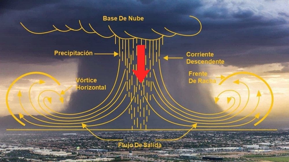
Scheme of violent wind gusts formation during a “downburst”
Until recently, “microbursts” were extremely rare. In recent years, they have begun to recur with alarming frequency, causing enormous damage. Moreover, these phenomena are impossible to forecast, which makes them even more dangerous.
With each passing year we see an increasing number of natural anomalies that were previously rare or never observed at all. Some of these phenomena are so unique that they are almost unstudied.
It is obvious that for urgent solutions to climate problems a comprehensive approach is required. It is necessary to create a unified scientific center with the participation of the world's best scientists.
This is why, before it is too late, it is necessary to tell all people about the climate problem and create a demand for uniting scientists from all over the world. You can find out more at the International Forum “Global Crisis. The Responsibility.”
Watch the video version of this article here.
Leave a comment