Summary of Climate Disasters on the planet from July 3 to July 9, 2024
Italy
Red alert was declared on the Italian island of Sicily due to the simultaneous eruption of two volcanoes, Etna and Stromboli.
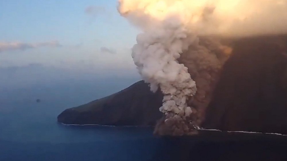
Mount Etna, the highest volcano in Europe, located on the eastern coast of the island, had been showing increasing activity over the three weeks until July 4, when a powerful eruption occurred, with lava fountains and a volcanic ash cloud reaching about 5 km (3 miles) high.

Mount Etna spews lava fountains and ash clouds, Sicily, Italy
In the province of Catania, ash covered roads, sidewalks, cars, as well as the runway of the local airport. As a result, from July 5 its operations were suspended, and at least 90 flights were canceled, affecting around 15,000 passengers.

Streets covered in ash in the province of Catania, Italy
Riding bicycles and motorcycles in the city was prohibited for two days, and the speed limit for all vehicles was restricted to 30 km/h (19 mph).
Simultaneously with Etna, Mount Stromboli became active and released a stream of lava that rapidly flowed into the sea down the slope of the mountain.
Eruption of Stromboli volcano, Italy
Volcanologist Piergiorgio Scarlato from the National Institute of Geophysics and Volcanology (INGV) commented: “...On July 4, there were numerous landslides and pyroclastic flows on Sciara del Fuoco, which significantly changed the morphology of the volcano. Undoubtedly, the situation is developing, we are checking whether there are other areas that may collapse due to instability and cause new landslides, and there is also a lava flow on Sciara del Fuoco, which may either subside or intensify. The interaction between lava and water caused additional explosions, far from populated areas.”
Summer in Sicily is becoming unbearable for many. Last year, severe wildfires forced tourists to evacuate or cancel their trips. This summer, in addition to the activation of volcanoes, the island is suffering from drought and water shortages.
South Korea
Since July 8, record-breaking rains have hit South Korea. They caused floods, triggered landslides, and led to the loss of life and destruction. The provinces of Chungcheongnam-do and Jeollabuk-do were severely affected.
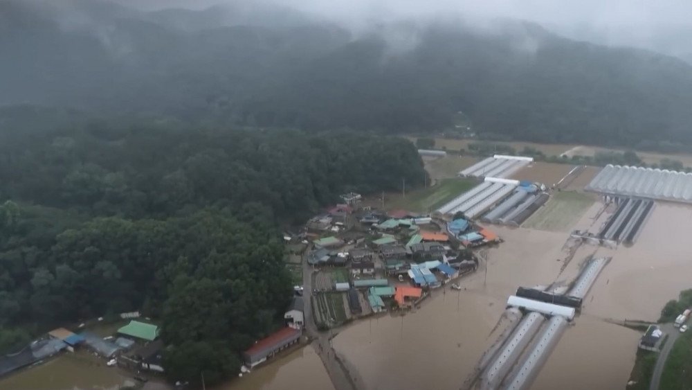
Vast areas flooded in South Korea
Due to the rampant disaster, more than 3,500 people were displaced and about 1,600 people evacuated.

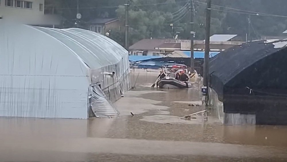
Helicopters deployed to rescue people from flooded areas, South Korea
According to the Central Disaster and Safety Countermeasures Headquarters, as of July 11, seven people died. The search for the missing continues.
About 1,600 people were evacuated during the flood in South Korea
In the city of Gunsan, Jeollabuk-do province, 131.7 mm (5.19”) of rain fell in one hour, exceeding 10% of the 1,246 mm (49.06”) average annual rainfall in the region. This was the largest amount of rain in one hour in the country's history.
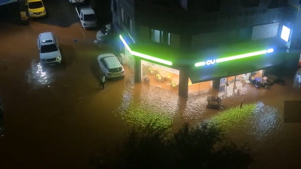
Streets flooded in Gunsan, Jeollabuk-do province, South Korea
In the city of Wanju, Jeollabuk-do province, rescuers evacuated villagers who were waiting for help on the roofs of houses. An elderly man was barely rescued—he had been hanging for a long time, grabbing onto a pole.
The torrential rain led to the cancellation of 21 flights at Gimhae International Airport in Busan and delays of 16 more flights.
All rail services on the Janghang Line in Chungcheongnam-do province and the Gyeongbuk Line in Gyeongsangbuk-do province were suspended.
China
According to the Shandong Provincial Climate Center, tornadoes are extremely rare in this Chinese province. The average annual rate for the period 1991–2020 is 1.5 tornadoes per year. But according to the Emergency Management Department of Shandong Province, just in the first two days of July, at least 3 destructive tornadoes hit the province.
On July 4, a tornado struck Yinan County in Linyi City, causing trees to fall; fortunately, no one was injured.
On July 5, a tornado appeared in Dongming County, Heze City. It traveled from west to east across the county, breaking trees, ripping roofs, and scattering cars. Powerful tornadoes also broke out in Juancheng County and other areas of Heze City.
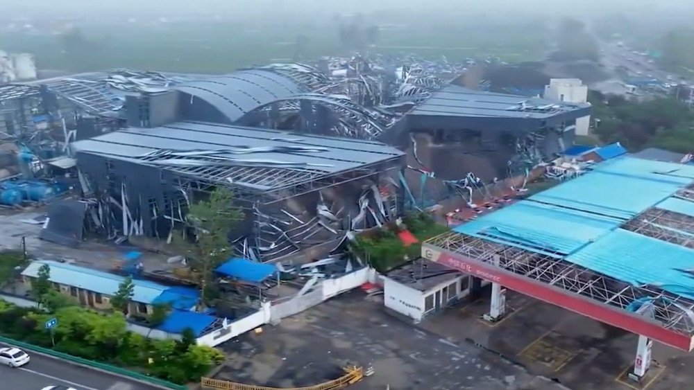
Tornado damage, Heze City, Shandong province, China
As of July 6, 83 people were injured and five died as a result of the tornadoes.
A total of 2,830 houses, 48 power lines, and 24,645 hectares (60,899 acres) of agricultural land were damaged.
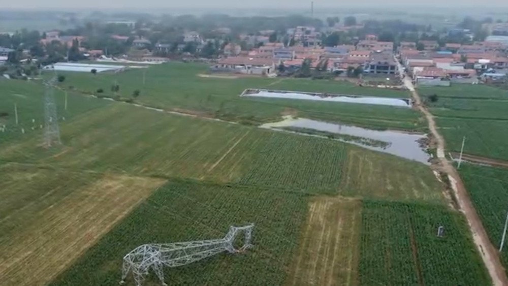
Damage to agricultural land and power lines from tornadoes, Shandong province, China
Not only in Shandong province but also in China in general, tornadoes were quite rare. For example, Jiangsu province has the highest number of tornadoes per year in China with an average of 4.8 per year, followed by Guangdong province with 4.3.
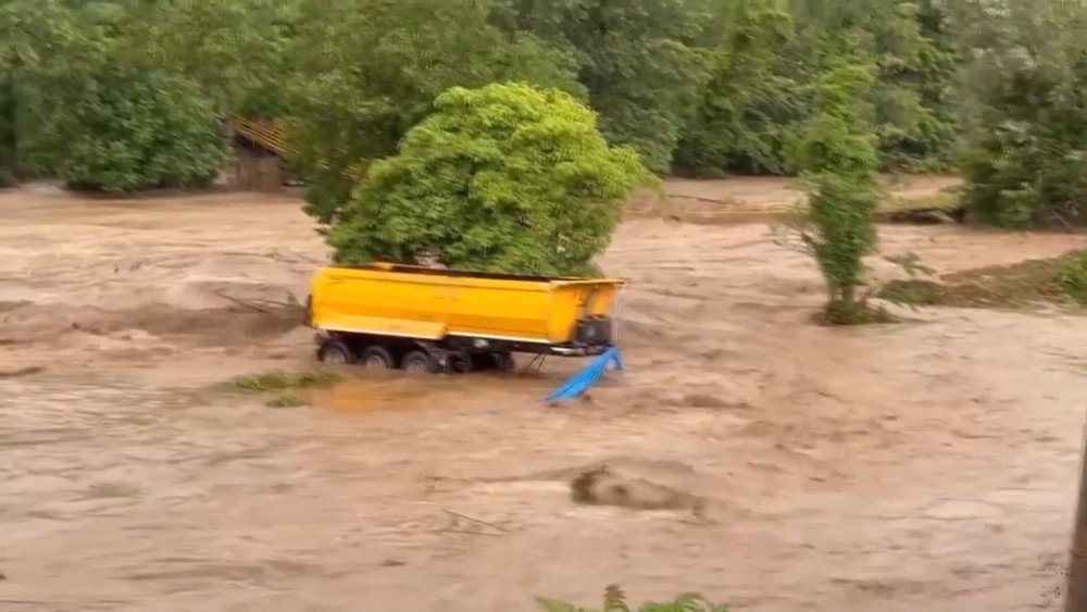
On July 5, a dam breach at Dongting Lake in Hunan province caused a massive flood.
This was
the first such incident since 1996.
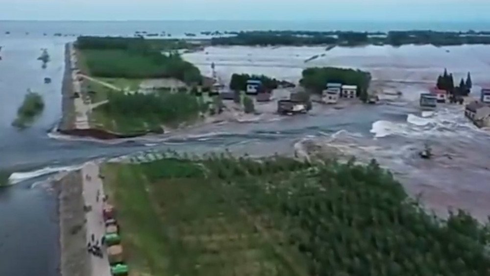
Dam breach at Dongting Lake, Hunan province, China
A breach
226 meters (741.5 ft) long
formed in the dam, and water poured through it onto fields and villages, flooding houses up to the roofs. Nearly 6,000 people were forced to evacuate.

Houses flooded up to the roofs due to the dam breach at Dongting Lake, Hunan province, China
Japan
Japan is experiencing dangerous heat. The Japan Meteorological Agency issued a heatstroke warning for 26 of the country's 47 prefectures. On July 7, the temperature in Shizuoka Prefecture reached +40°C (104°F), which is record high since the beginning of meteorological statistics. It's worth noting that the previous record for July's maximum temperature was set on July 13, 2004, at +37.9°C (100°F).
According to the Japan Meteorological Agency,
the temperature reached +35°C (95°F) and higher in 244 other locations across the country.
Abnormally high temperatures were recorded in Shingu, Wakayama Prefecture, at +39.6°C (103°F) and in Fuchu, Tokyo, at +39.2°C (102°F).
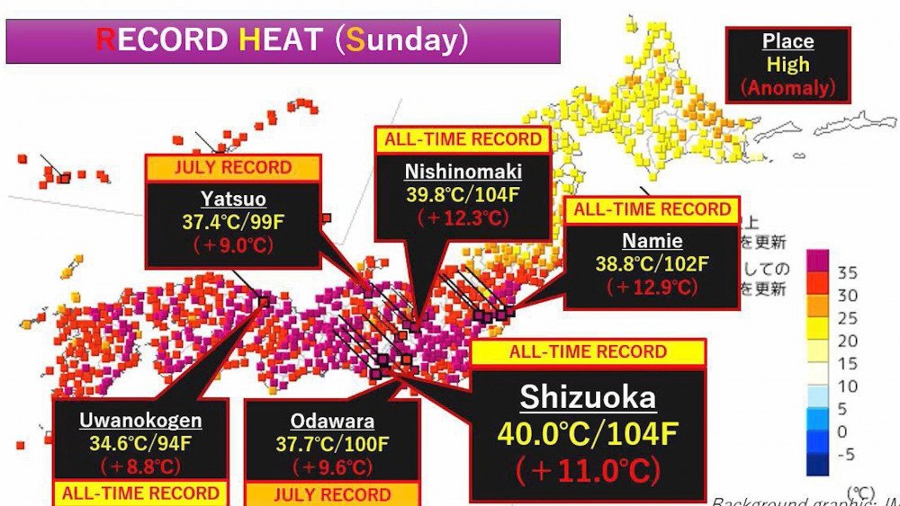
Record temperature of +40°C (104°F) recorded in Shizuoka Prefecture, with temperatures reaching +35°C (95°F) and higher in hundreds of other locations, Japan
In recent years, heat-related mortality in Japan has increased sixfold.
Average number of deaths related to heatstroke:
1995–1999 — 201 people per year;
2018–2022 — 1,295 people per year.
On July 8, at least 435 people aged 2 to 102 were taken to hospitals with suspected heatstroke.
In total, during the first week of the month, from July 1 to July 7,
6,829 people were hospitalized with this diagnosis.

Residents of Japan suffer from the heat across the entire country
Turkey
Due to torrential rains this week, the Turkish Meteorological Service issued one warning after another. Water flooded buildings and roads, causing damage to the infrastructure of cities as well as agricultural lands. Ordu Province was particularly affected.
On July 7, in the İkizce district,
186.7 mm (7.35”) of rainfall was recorded in one day
(the average monthly norm for July is 79 mm (3.11”) of rain).
Flooding caused severe damage to farmland in Ordu Province, Turkey
Water overflowed riverbanks and flooded streets, sweeping away cars and bridges. At least two people died due to the disaster.
After heavy rains, landslides occurred in many areas. One of the landslides blocked the Ünye-İkizce highway.

Water overflowed riverbanks, flooded streets, damaged roads, and swept away bridges, Ordu Province, Turkey
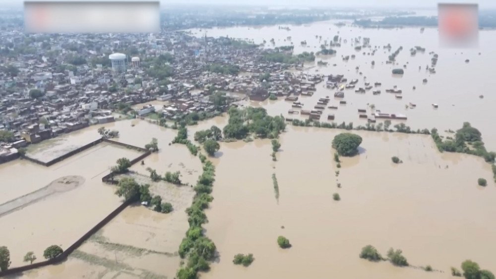
India
Many states in India, such as Assam, Maharashtra, Bihar, Uttarakhand, and Uttar Pradesh, continue to struggle with floods amid extreme rains.
On July 9, the India Meteorological Department issued
a red alert due to high tide and heavy rains
in the cities of Mumbai and Pune, Maharashtra state.

Heavy rains caused flooding in several states of India
On July 8, before the morning rush hour, Mumbai, a city of 12 million people, was hit by 300 mm (11.81”) of rain in just 6 hours which is more than half of the monthly norm (the average monthly rainfall for July is 593 mm (23.35”)).
Mumbai, the financial center of India, was paralyzed by flooding, as commuter trains, critical for the movement of millions of people, were stopped due to flooded railway lines.

Due to flooding, railway services were suspended in the suburbs of Mumbai, India
According to the Flightradar24 service website, due to poor visibility at the city's airport,
36 flights were canceled, and over 300 flights were delayed.

The raging disaster paralyzed air traffic, Mumbai, India
In Assam state, 92 people have already died from storms, floods, and landslides.
Nearly 2.3 million residents were forced to leave their homes in 3,446 villages.
The total
number of affected people in 30 districts of the state reached 24.5 million.

The number of people affected by the flood reached 24.5 million, Assam state, India
Huge damage was inflicted on agriculture: more than 68,000 hectares (168,032 acres) of arable land were flooded.
The disaster not only destroyed roads, bridges, and houses in thousands of villages across the state but also severely damaged Kaziranga National Park. This park is home to two-thirds of the world's population of one-horned rhinos, which are listed in the Red Book, and many other wildlife species.
114 wild animals died from the flood, which is
one of the highest mortality rates in the park's history.

Record animal deaths, including Red Book animals, in Kaziranga National Park, Assam, India
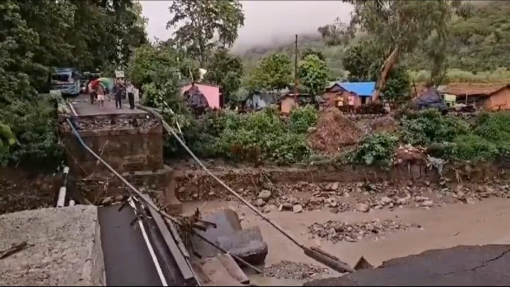
In Uttarakhand state, a landslide occurred on the national highway between Joshimath and Badrinath.
Thousands of passengers were stranded on both sides of the road.

A landslide in Uttarakhand state blocked the road between Joshimath and Badrinath, India
In Almora city, Uttarakhand state, a bridge on the Ramnagar-Ranikhet road was destroyed by a powerful water flow, forcing residents to cross the strong river current, risking their lives, to get to work or school.
Bridge destruction in Almora forced residents to wade through the river, risking their lives, India
In Pilibhit city, Uttar Pradesh state, heavy rain did not stop for a whole day, turning many villages into islands. Rivers and streams overflowed to such an extent that culverts under the railroad tracks were washed away by the heavy water flow and rails were swaying in the air. All train traffic on this route was halted.
Due to the disaster, seven people died in the state.
The flood in the Pilibhit area turned many villages into islands, Uttar Pradesh state, India
USA
Record-breaking Hurricane Beryl devastated Caribbean countries, then crossed the Gulf of Mexico, weakened to Category 1, and hit the coast of Texas in the USA.
Beryl caused the deaths of at least 12 people in the states of Texas and Louisiana.
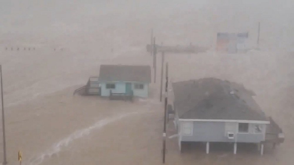
Hurricane Beryl brought massive destruction to the coast of Texas, USA
The hurricane brought heavy rains and strong winds. Roads turned into raging rivers. Power lines were severed, and most hotels and buildings on the coast suffered roof damage. There were cases when huge trees fell and broke houses in half.

Most buildings on the coast of Texas were damaged by Hurricane Beryl, USA
In Brazoria County, peak wind gusts reached 156 km/h (97 mph). In the Houston area, wind gusts up to 128.7 km/h (80 mph) damaged the retractable roof of NRG Stadium, home of the Texans football team, and overturned several trucks.
Storm surge and heavy rains caused flooding.
In some parts of Houston,
213 mm (8.39”) of rain fell, which is comparable to the average rainfall for the entire summer
(the average rainfall in Houston from June to August is 245 mm (9.65”)).

Hurricane Beryl caused severe damage to Houston's infrastructure, USA
Hurricane Beryl left more than 2.7 million homes without power.
Restoring power might take several days or weeks. The situation is exacerbated by unbearable heat and humidity prevailing in the state these days. The heat index in Houston reached 37.8°C (100°F).
On July 8, it was so hot in New York City that the Third Ave Bridge over the Harlem River got stuck in the open position due to overheating and expansion of its steel structures. Fireboats sprayed water on the bridge to cool it down.
The nonfunctioning bridge caused massive traffic jams during the evening rush hour.
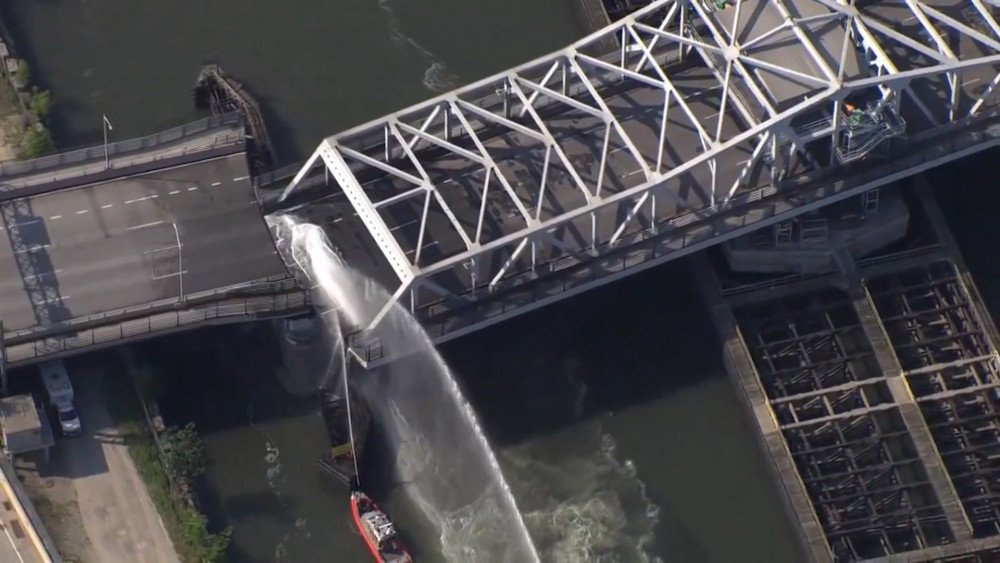
Record heat caused critical overheating of the steel structures of the Harlem River bridge in New York, USA
Record heat continues to scorch the western USA. 14 weather stations set new historical temperature records.
In California, abnormally high temperatures were recorded: Palm Springs — +51°C (124°F), Redding — +48°C (118°F), Fresno — +45°C (113°F), Bishop — +44°C (111°F).
On July 6, a group of motorcyclists suffered severe heatstroke after riding through Death Valley National Park. That day, the air temperature reached 53.3°C (128°F). Due to extreme heat, emergency medical helicopters could not fly to the victims, as flying at temperatures above +48.8°C (120°F) is unsafe. Unfortunately, one person died.
It's inconceivable, but despite the deadly heatwave in the USA,
tourists continue to flock to Death Valley…

Tourists continue to flock to Death Valley despite meteorologists' warnings of life-threatening heat, California, USA
It is important for all of us to understand that the climate situation is more than serious.
However, many continue to take risks for entertainment and profit. Tourists visit regions where weather hazard warnings have already been issued, and business owners are willing to exploit these places for financial gain, regardless of the threat to people's lives.
The world is facing growing climate challenges, and it is time for each of us to take responsibility. It's time to leave our favorite sandbox and grow up. By sharing information about the increasing danger, we will not only help those around us to acknowledge the reality and stop being careless about their lives, but together we can find a solution to eliminate the cause of climate disasters by taking timely and comprehensive measures.
We are responsible for the planet and life on it!
You can view the video version of this article here.
Leave a comment