Summary of Climate Disasters on the Planet: February 5-11, 2025
The climate continues to bring new and unpleasant surprises. We often fail to realize what consequences a particular climate anomaly might have for us. And the events of the past week, from February 5 to February 11, 2025, illustratively demonstrated this.
Middle East
A low-pressure system carrying cold polar air masses covered the Middle Eastern countries from February 5 to 7. This led to a sharp drop in temperatures, especially in mountainous regions, where in some areas, temperatures fell below 0°C (32°F).
In Lebanon’s Beqaa Valley, heavy snowfall resulted in road closures.
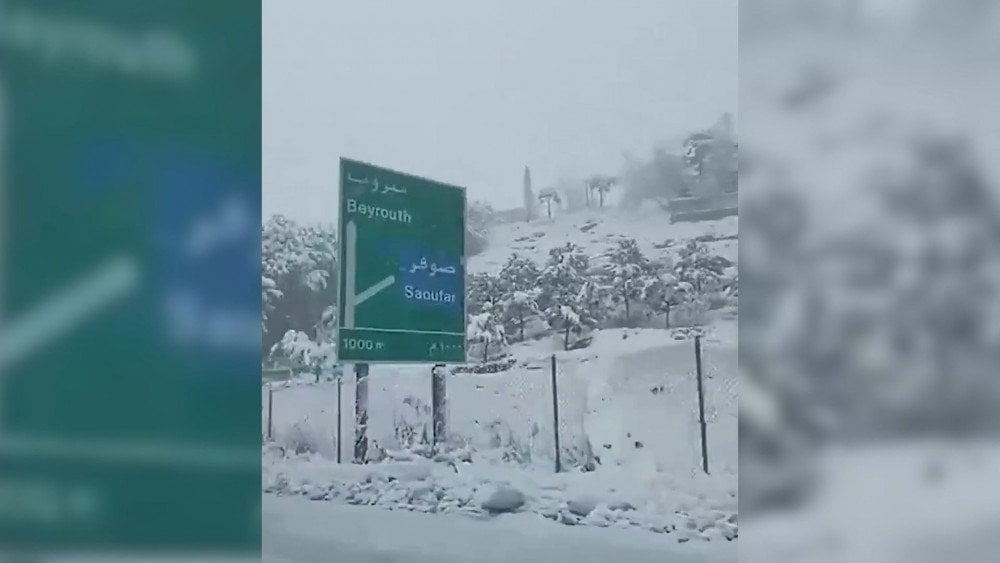
Unprecedented snowstorm in Lebanon
In Jordan, heavy precipitation affected the northern and central regions of the country. At the Rās Munīf weather station in the Ajloun region, 86.8 mm (3.42 in) of precipitation was recorded, which is 1.5 times the monthly average. At the same time, snowfall occurred in the mountains.
In the southeast of the country, rain was accompanied by thunder, hail, and strong westerly winds with gusts sometimes exceeding 100 km/h (62 mph).
On February 6, a severe sandstorm hit the Ma'an governorates, leading to road closures due to poor, and at times zero, visibility.

Near-zero visibility due to sandstorm in Ma’an, Jordan
In the center of Ma’an, hurricane-force winds knocked down trees onto power lines, ripped water tanks and panels from rooftops, and shattered car windows.
In Israel, the storm brought a sharp temperature drop. One person died from hypothermia, and another was hospitalized in critical condition. In Jerusalem, the temperature dropped to +8°C (46°F).
Fallen trees and downed power lines due to strong winds blocked traffic on the Begin Expressway.

Downed power line blocks traffic on expressway, Jerusalem, Israel
Iran
In early February, a wave of cold, floods, and snowstorms swept across many regions of Iran. In the city of Ilam, snowfall was accompanied by thunderstorms and lightning. Snowdrifts in some areas reached heights of 80 cm (31 in).
A total of 2,500 people were rescued from snow traps on the roads.

Car buried under a massive amount of snow, Iran
In Kurdistan Province, temperatures dropped to an extreme −21°C (−6°F). Schools, banks, and government institutions were closed in 20 provinces of Iran.
In Gilan Province, unprecedented rainfall caused rivers to overflow and triggered large-scale flooding. In Rasht, on February 8, a record-breaking 107 mm (4.2 in) of precipitation fell in just 24 hours. At least 2,000 households were affected.

Record rainfall in Gilan province floods streets, Iran
Caribbean Region
On February 8, a powerful M7.6 earthquake struck the Caribbean Sea near the Cayman Islands. According to the United States Geological Survey (USGS), the earthquake's hypocenter was located at a depth of approximately 10 km (6.2 mi).
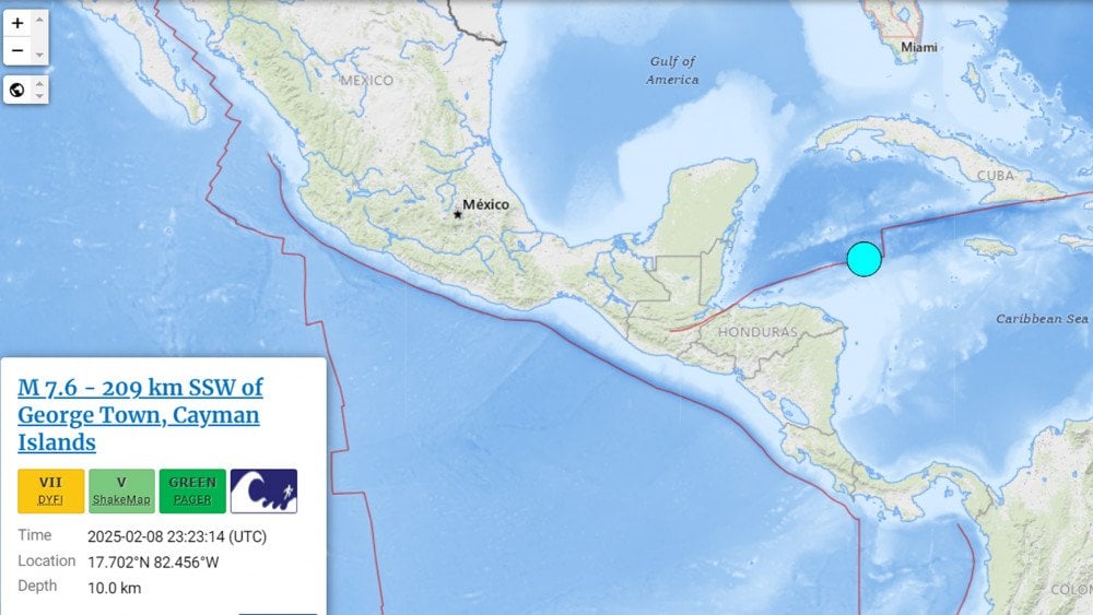
Powerful M7.6 Earthquake in the Caribbean Sea
The tremors were felt in multiple regions, including Puerto Rico, Honduras, Cuba, and the Virgin Islands. Initially, a tsunami threat was issued for 20 countries and islands, including Belize, Cuba, Haiti, Jamaica, the Bahamas, and the Cayman Islands. However, the warning was later lifted.
United States
Starting on February 6, a powerful winter storm swept across vast areas of the U.S., from Tennessee to New England. It brought heavy precipitation, freezing rain, snowfall, and even tornadoes.
In the Mid-Atlantic region, an ice storm left surfaces covered in ice up to 11 mm (0.43 in) thick.
The storm impacted the Blue Ridge area and the Piedmont region of Virginia.

Ice accumulation on vaious objects due to freezing rain, U.S.
More than 90,000 homes lost power due to ice-laden trees falling onto power lines. Power outages were reported in Ohio, West Virginia, Virginia, Maryland, Pennsylvania, and New Jersey.
Icy roads caused numerous traffic accidents. Hundreds of flights were canceled or delayed, particularly at airports in Philadelphia, Washington, Boston, and New York City.
A rare meteorological phenomenon—“thunder ice”—was observed in parts of Indiana, southern Michigan, Ohio, and Pennsylvania, where freezing rain was accompanied by flashes of lightning and thunder.
West Virginia was hit by torrential rains, causing rivers to overflow. Emergency services carried out dozens of rescues in flooded areas.
Several tornadoes struck Kentucky, while in Tennessee, a powerful EF-2 tornado tore through Morgan County, killing two people and injuring three others. Maximum wind speeds reached 217 km/h (135 mph).

Building completely destroyed by a powerful tornado in Morgan County, Tennessee, U.S.
Between February 8 and 9, another strong winter storm hit the Northeastern U.S., affecting Minnesota, Wisconsin, Michigan, Vermont, New Hampshire, western Maine, Connecticut, and New York.
Up to 30 cm (12 in) of snow fell in some areas. In Minneapolis, heavy snowfall prompted the declaration of a state of emergency.
Then, on February 11, yet another storm arrived, bringing heavy snow to Washington, D.C., Baltimore, and surrounding regions. In Washington, D.C., an astonishing 10 cm (4 in) of snow fell in just four hours, paralyzing traffic and delaying hundreds of flights at Reagan National Airport.
The snowstorm wreaked havoc on the roads—over 850 accidents were reported in Virginia and Maryland within 24 hours.
China
On February 8, a landslide struck Jinping Village, Yibin County, Sichuan Province, China. The landslide buried 10 homes and one industrial building. Two people were injured, and more than 200 residents were evacuated.

Massive landslide hits Jinping village, Sichuan Province, China
The hazardous geological conditions at the disaster site severely complicated search operations. Rescue teams had to work on unstable ground, with rocks periodically falling from the mountainside.
According to official reports, one person was killed, and 28 remain missing.
Japan
According to the Japan Meteorological Agency, a low-pressure system triggered record-breaking snowfall across vast areas of Japan, starting on February 4.
The hardest-hit regions were along the Sea of Japan coast, where 129 cm (50.8 in) of snow fell within 48 hours—the highest amount recorded since meteorological observations began in 1983.
In Obihiro, Hokkaido Prefecture, an unprecedented 120 cm (47.2 in) of snow fell in just 12 hours, setting a national record for the most intense snowfall in Japan’s history.
Experts warned that if such heavy snowfall continues for more than three days, many building roofs may collapse under the accumulated weight.

Snowfall in Obihiro, Hokkaido prefecture—the most intense ever recorded in Japan
After several days of intense snowfall, snowdrifts in Sukaya, Aomori Prefecture, reached a height of 4.37 meters (14.3 ft).
Highways and national roads were closed due to the extreme weather.
In the Oku-Noto region, over 90% of roads equipped with snow-melting systems had been damaged more than a year ago by the M7.6 earthquake on January 1, 2024. As a result, the snow-melting equipment could not be used, further complicating road conditions.
Iceland
Between February 5 and 6, Iceland was hit by one of the strongest storms in recent years to arrive from the south. A red weather alert was issued across almost the entire country.
The strongest wind gust—66.3 m/s (238.7 km/h or 148.4 mph)—was recorded on February 5 at the Gagnheiði mountain weather station in Eastern Iceland. This was the strongest wind speed recorded in the past 24 years.
Additionally, wind gusts exceeded 40 m/s (144 km/h or 89 mph) at 77 stations across the country.
As a result, over 40 flights were canceled at Keflavík International Airport.
The storm severely damaged infrastructure, with fiber optic and power cables sustaining damage.
Many homes suffered significant damage—windows were shattered, roofing sheets were torn off, and heavy rain flooded city streets and basements.
The storm was accompanied by thunder and lightning, which could be seen across Iceland—an extremely rare phenomenon for the subarctic climate of the country, especially in winter.
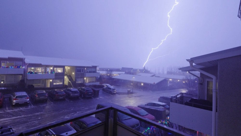
Lightning during a winter storm in Iceland
Brazil
In the Brazilian state of Pernambuco, two days of torrential rains from February 5 to 6 triggered flooding and numerous landslides.
On February 5, 92 mm (3.62 in) of rain fell in just three hours in Recife, surpassing the city's February monthly average of 91.4 mm (3.6 in).
Over two days, 200 mm (7.87 in) of rain fell—an all-time record for February in the city's history of observations.
Due to the storm, schools suspended classes, and government offices and shopping centers closed.
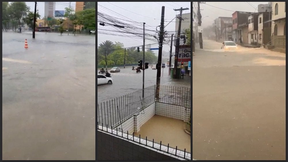
Record-breaking rain triggers severe flooding in Recife, Pernambuco state, Brazil
Recife’s central metro line, which serves 150,000 passengers daily, was shut down.
In the Greater Recife metropolitan area, 18 municipalities were completely or partially left without water supply.
Tragically, seven people lost their lives.
Meanwhile, an enormous anticyclone that formed over Siberia extended more than 8,000 km (4,970 mi) from the British Isles to the Russian Far East.
Russia
Dubbed a “barometric monster” by some experts, an anticyclone brought multiple atmospheric pressure records to European Russia!
In St. Petersburg, on February 8, atmospheric pressure exceeded 1,055 hPa—the highest February reading in the city's recorded history.
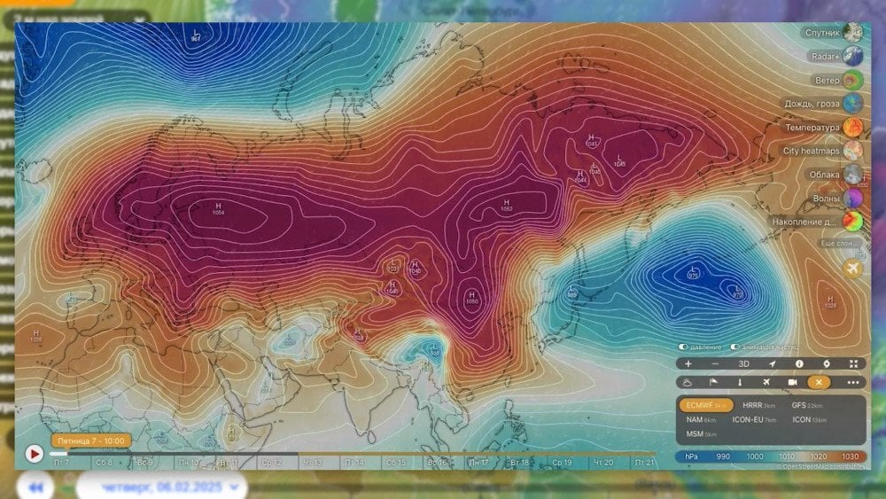
A massive anticyclone has covered almost all of Eurasia
This weather anomaly affected not only weather-sensitive individuals but also technology. In some cars, “check engine” indicators were triggered. According to specialists, this could have been caused by overloading of the turbo pressure sensor, due to the exceptionally high atmospheric pressure.
At Pulkovo Airport, all Sukhoi Superjet 100 flights were canceled, as the critical devices of these aircraft are not designed to operate above 1,050 hPa. In the area around the airport, atmospheric pressure reached 1,054 hPa.
In Moscow, a February barometric record for the 21st century was also set. At the VDNKh meteorological station, the daily high-pressure record was broken two days in a row: February 7 – 1,033.5 hPa, February 8 – 1,034.8 hPa. For comparison, the February norm for the region is 996 hPa.
It is well known that anticyclones bring clear, frosty weather in winter. However, despite atmospheric pressure exceeding the norm by 30 units, and contrary to modern forecasting models, the sky over Moscow Region remained covered in thick clouds, and in Dmitrov District, it even snowed.
This anomaly left specialists puzzled. Once again, these events have shown that humanity knows far too little about what is happening to the climate and remains unprepared for new natural anomalies. Who could have predicted that an anticyclone would cause unexpected issues for car owners? And yet, this is far from the worst we might face. In our modern world, everything—including critical infrastructure—depends on electronics, which can fail under the impact of extreme natural events.
Right now, we only see a small fraction of the hidden risks, but as climate disasters intensify, these risks will multiply. We must be prepared for the challenges ahead, and to do that, we must unite the planet’s scientific potential—to deepen our understanding of the climate crisis, uncover its hidden dangers, and most importantly, find the path to a final solution.
You can watch the video version of this article here:
Leave a comment